Method and device for drawing electronic map

An electronic map and frame image technology, applied in image analysis, image enhancement, image data processing, etc., can solve problems such as high cost and inaccurate positioning results

Active Publication Date: 2021-11-19
BEIJING SANKUAI ONLINE TECH CO LTD
View PDF3 Cites 4 Cited by
  • Summary
  • Abstract
  • Description
  • Claims
  • Application Information

AI Technical Summary

Problems solved by technology

But this way is more costly
For another example, it is also possible to locate traffic elements through a binocular camera, thereby drawing traffic elements in a high-precision map. However, the method of positioning through a binocular camera requires pre-calibrating the external parameters between the binocular cameras. Then the positioning Loosening of any one of the binocular cameras during the process can easily lead to inaccurate positioning results

Method used


Image

  • Method and device for drawing electronic map
  • Method and device for drawing electronic map
  • Method and device for drawing electronic map

Examples


Embodiment Construction

[0054] In order to make the purpose, technical solution and advantages of this specification clearer, the technical solution of this specification will be clearly and completely described below in conjunction with specific embodiments of this specification and corresponding drawings. Apparently, the described embodiments are only some of the embodiments in this specification, not all of them. Based on the embodiments in this specification, all other embodiments obtained by persons of ordinary skill in the art without creative efforts fall within the protection scope of this specification.

[0055] The technical solutions provided by each embodiment of this specification will be described in detail below in conjunction with the accompanying drawings.

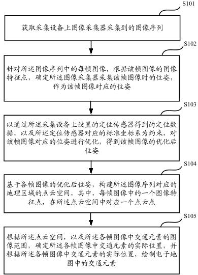
[0056] figure 1 It is a schematic flowchart of a method for drawing an electronic map in this specification, including the following steps:

[0057] S101: Obtain an image sequence collected by an image collector on a collection...


PUM


Abstract

The invention discloses a method and a device for drawing an electronic map. The method comprises the steps: obtaining an image sequence collected by an image collector on collection equipment; determining the pose when the image collector collects a frame of image for each frame of image in the image sequence, and enabling the pose to serve as the pose corresponding to the frame of image; taking positioning data obtained by a positioning sensor arranged on the collection equipment and a standard coordinate system corresponding to the positioning sensor as constraints, and optimizing the pose corresponding to the frame of image to obtain an optimized pose of the frame of image; constructing a point cloud space of a geographic area corresponding to the image sequence based on the optimized pose of each frame of image; according to the point cloud space and the image range of traffic elements in each frame of image, determining actual positions of the traffic elements in each frame of image, and drawing the traffic elements in an electronic map according to the actual positions of the traffic elements in each frame of image. In this way, the cost can be saved, and the accuracy of positioning the traffic elements is ensured.

Description

technical field [0001] This specification relates to the field of unmanned driving, in particular to a method and device for drawing an electronic map. Background technique [0002] In the field of unmanned driving, high-precision maps are an extremely important part. In high-precision maps, the positions of various traffic elements (such as traffic lights, prohibition signs, warning signs, and instruction signs, etc.) need to be recorded, so that Ensure that the unmanned driving equipment can notice the traffic elements in time when it arrives at the location where there are traffic elements, and determine the corresponding control strategy in time. [0003] In the prior art, there are many ways to locate traffic elements in drawing high-precision maps. For example, traffic elements can be positioned by a map collection vehicle equipped with a laser radar and a camera, so that according to the positioning results in the high-precision map The traffic elements are drawn in ...

Claims


Application Information

Patent Timeline
Patent Type & Authority Applications(China)
IPC IPC(8): G06T17/20G06T17/05G06T7/73
CPCG06T17/20G06T17/05G06T7/73G06T2207/30244
Inventor 陆亚任海兵胡琦舒畅申浩夏华夏
Owner BEIJING SANKUAI ONLINE TECH CO LTD
Why Eureka
Try Eureka