Visual planning auxiliary system based on three-dimensional GIS

An auxiliary system and planning technology, applied in the field of engineering management, can solve problems such as communication barriers, human-computer interaction content, and project management cannot be carried out, and achieve the effect of reducing communication time

Pending Publication Date: 2021-11-30
寰球孪生空间设计(云南)有限公司
View PDF0 Cites 0 Cited by
  • Summary
  • Abstract
  • Description
  • Claims
  • Application Information

AI Technical Summary

Problems solved by technology

[0003] First, traditional planning and design intentions are mainly expressed through line drawings and effect diagrams, accompanied by text descriptions. However, reading and understanding design intentions requires a certain basis for understanding drawings, and requires a high level of basic knowledge for those who understand drawings; although some projects will Build a model to express the design intention and effect, but the BIM model based on the virtual scene is generally established, the design intention and effect display is poor, the expression is not intuitive, the relevant personnel or stakeholders cannot understand, the understanding is not in place, and there is communication Obstacles; part of the large-scale 3D scenes that will be used in the planning and design display, but most of them use lower-precision geographic information data as shoddy. Under the premise that the 3D GIS data cannot be guaranteed with higher precision, it can only The management function is fully placed on the refined BIM model; however, many small-scale projects do not build BIM models, and more complex projects with long construction periods generally follow the BIM workflow after design; after using BIM to display, it is completely It fails to achieve the overall management purpose of coordination and communication in the early stage of the project and the project construction process;
[0004] Second, when GIS is used in a large-scale scene, high- and low-precision geographic information data cannot be integrated, and three-dimensional display can only be displayed separately, and cannot be f

Method used


Image

  • Visual planning auxiliary system based on three-dimensional GIS
  • Visual planning auxiliary system based on three-dimensional GIS
  • Visual planning auxiliary system based on three-dimensional GIS

Examples


Embodiment 1

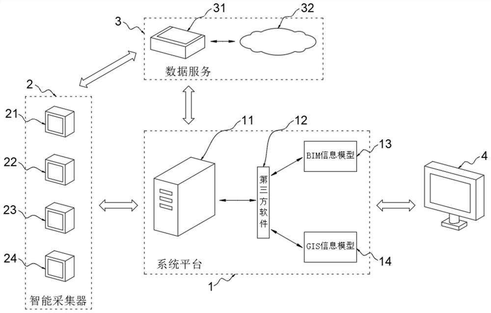
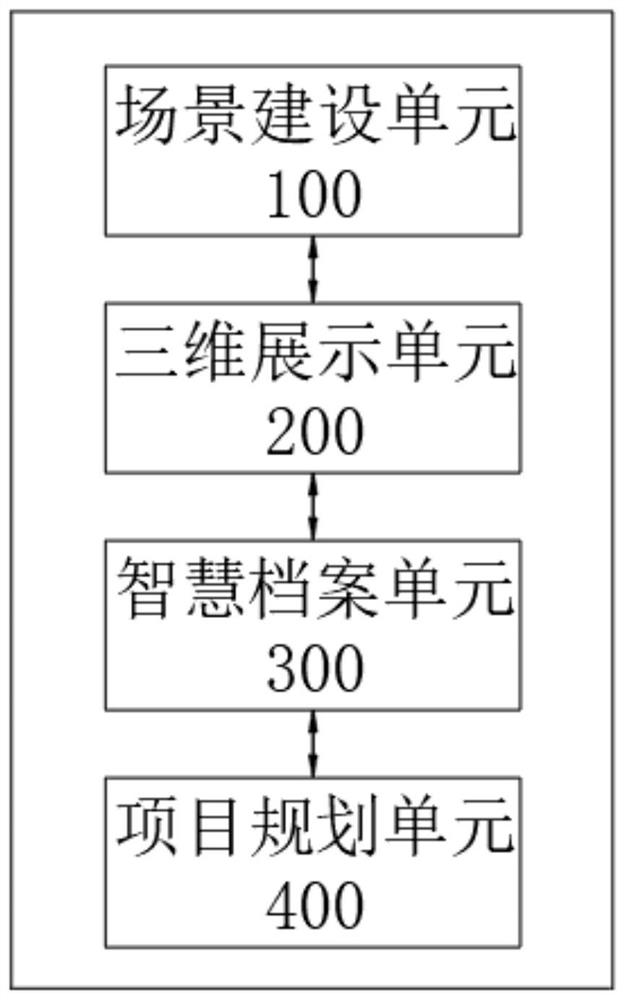
[0083] Such as Figure 1-Figure 10 As shown, this embodiment provides a visual planning assistance system based on 3D GIS, including

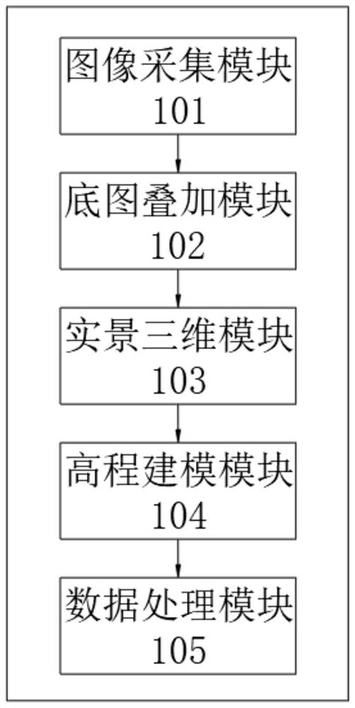
[0084] The scene construction unit 100, the three-dimensional display unit 200, the smart archive unit 300 and the project planning unit 400; the scene construction unit 100, the three-dimensional display unit 200, the smart archive unit 300 and the project planning unit 400 are sequentially connected through network communication; the scene construction unit 100 uses To collect images, pictures and other relevant data of the construction environment and build a real 3D model of the scene through software to form a real 3D environment; the 3D display unit 200 is used to three-dimensionalize the planning and design results and select the most suitable model for display; smart files The unit 300 is used to realize the three-dimensional visualization management of the archives by using the archives management database superimposed on the geographi...


PUM


Abstract

The invention relates to the technical field of engineering management, in particular to a visual planning auxiliary system based on a three-dimensional GIS (Geographic Information System). The system comprises a scene construction unit, a three-dimensional display unit, a intelligent file unit and a project planning unit. The scene construction unit is used for constructing a live-action three-dimensional model; the three-dimensional display unit is used for three-dimensionally displaying the planning and design result; and the intelligent archive unit is used for realizing three-dimensional visual management of archives. According to the design, high-precision and low-precision data are fused in the same scene, and browsing at any position and from any view angle, real-time data measurement and basic data analysis can be achieved; a design result can be quickly modeled, and the communication time can be intuitively presented and compressed; on-line three-dimensional visual management can be realized on all the archives; planning and design results can be improved and optimized in the project management process, and project engineering construction is assisted; The database service can be carried out in two modes of a standalone version and a network version.

Description

technical field [0001] The invention relates to the technical field of engineering management, in particular to a visual planning auxiliary system based on a three-dimensional GIS. Background technique [0002] During the planning, design, and pre-construction process of the project, it is necessary to accurately manage the detailed information of the project's environmental terrain, engineering structure and other entities, which usually includes a large number of design drawings, measurement data, and electronic file data. However, there are still many deficiencies in the current commonly used engineering management methods, such as: [0003] First, traditional planning and design intentions are mainly expressed through line drawings and effect diagrams, accompanied by text descriptions. However, reading and understanding design intentions requires a certain basis for understanding drawings, and requires a high level of basic knowledge for those who understand drawings; al...

Claims


Application Information

Patent Timeline
IPC IPC(8): G06Q10/06G06Q10/10G06F30/13G06T17/05G06Q50/08
CPCG06Q10/0631G06Q10/103G06F30/13G06T17/05G06Q50/08
Inventor 杨颜江陈龙戚丽敏鲁宣智贺州龙
Owner 寰球孪生空间设计(云南)有限公司
Why Eureka
Try Eureka