
Source sink-ArcGIS system-based palaeodrainage pattern quantitative recovery and pickup method

A water system and system technology, applied in image data processing, special data processing applications, 3D modeling, etc., can solve problems such as inability to obtain DEM digital elevation models, and achieve the effect of overcoming subjectivity and uncertainty

Active Publication Date: 2022-01-14
CHINA UNIV OF GEOSCIENCES (WUHAN)
View PDF3 Cites 0 Cited by
  • Summary
  • Abstract
  • Description
  • Claims
  • Application Information

AI Technical Summary

Problems solved by technology

[0005] The main purpose of the present invention is to solve the technical problem in the prior art that the DEM digital elevation model of the ancient landform unit cannot be obtained directly through satellite data

Method used


Image

  • Source sink-ArcGIS system-based palaeodrainage pattern quantitative recovery and pickup method
  • Source sink-ArcGIS system-based palaeodrainage pattern quantitative recovery and pickup method
  • Source sink-ArcGIS system-based palaeodrainage pattern quantitative recovery and pickup method

Examples


Embodiment Construction

[0049] It should be understood that the specific embodiments described here are only used to explain the present invention, not to limit the present invention.

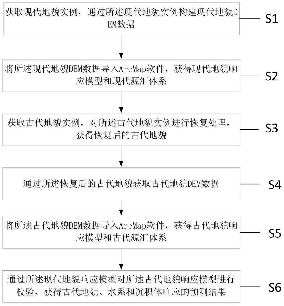
[0050] refer to figure 1 , the present invention provides a method for quantitative restoration and picking of paleowater systems based on source-sink-ArcGIS system, including:

[0051] S1: Acquire a modern landform instance, and construct a modern landform DEM data through the modern landform instance;

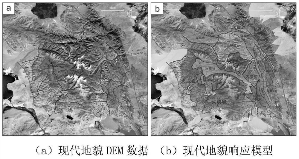
[0052] S2: importing the modern landform DEM data into ArcMap software to obtain the modern landform response model and the modern source-sink system;

[0053] S3: Obtain an instance of ancient landform, perform restoration processing on the instance of ancient landform, and obtain the restored ancient landform;

[0054] S4: Obtain ancient landform DEM data through the restored ancient landform;

[0055] The specific operation is: export the restored ancient landform results generated by the petrel software as CPS...


PUM


Abstract

The invention relates to the field of geological analysis, and provides a source sink-ArcGIS system-based palaeodrainage pattern quantitative recovery and pickup method, which comprises the steps of obtaining a modern landform instance, and constructing modern landform DEM data; importing the modern landform DEM data into ArcMap software to obtain a modern landform response model and a modern source-sink system; recovering on an ancient landform instance to obtain a recovered ancient landform; obtaining ancient landform DEM data through the recovered ancient landform; importing the ancient landform DEM data into ArcMap software to obtain an ancient landform response model and an ancient source-sink system; and verifying the ancient landform response model through the modern landform response model to obtain prediction results of ancient landform, water system and sedimentary body response. According to the method, water system picking can be carried out on ancient landform instances, so that ancient palaeodrainage system analysis is carried out; the difference of related parameters and combination styles of the palaeodrainage system can effectively reveal the difference of sedimentary bodies or reservoirs, and the subjectivity and uncertainty of traditional artificial water system picking are overcome.

Description

technical field [0001] The invention relates to the field of geological analysis, in particular to a method for quantitative restoration and picking of paleowater systems based on the source-sink-ArcGIS system. Background technique [0002] The development of the water system is affected by tectonic movement, landform and surface lithology, among which 1) tectonic movement is the internal driving force for the development of the water system, and fault structures have a great influence on the trend and dispersion characteristics of the water system; In terms of shape and boundary conditions, the near-circular and strip-shaped source regions have varying degrees of changes in the drainage unit and drainage pattern of steep and gentle slopes; 3) The difference in surface lithology will lead to the difference in the combination pattern of the drainage system and control the total amount of material transported. quantity. As a medium for transporting sediments, the water system...

Claims


Application Information

Patent Timeline
Patent Type & Authority Applications(China)
IPC IPC(8): G06F30/20G06T17/05
CPCG06F30/20G06T17/05
Inventor 刘强虎朱红涛鲍怡晨杨瑞袁帅李志垚
Owner CHINA UNIV OF GEOSCIENCES (WUHAN)
Learn More