Surveying and mapping instrument for engineering surveying and mapping

A surveying and mapping instrument and engineering technology, applied in the field of engineering surveying and mapping, can solve the problems of inability of data error, aging of lens, increase of surveying and mapping cost, etc., to achieve the effect of speeding up sliding speed and reducing hard friction

Active Publication Date: 2022-02-15
山东标至信土地房地产资产评估测绘有限公司
View PDF6 Cites 6 Cited by
  • Summary
  • Abstract
  • Description
  • Claims
  • Application Information

AI Technical Summary

Problems solved by technology

[0004]Aiming at the deficiencies of the prior art, the present invention provides a surveying and mapping instrument for engineering surveying and mapping, which has the advantages of automatic calibration and balance of levers and prolonging the service life of the lens, and solves the problem of The uneven ground proposed in the background technology will cause the surveying instrument to be tilted as a whole, and the data measured by the inclined surveying instrument will have errors, and artificially cannot effectively calibrate and adjust the surveying instrument in the inclined state. The limitations are large and the surveying instrument passes through the lens. When observing the observation point, the strong sunlight will reflect the lens and affect the effect of surveying and mapping, and the ultraviolet rays produced by sunlight will accelerate the aging of the lens and increase the cost of surveying and mapping 39 problems

Method used


Image

  • Surveying and mapping instrument for engineering surveying and mapping
  • Surveying and mapping instrument for engineering surveying and mapping
  • Surveying and mapping instrument for engineering surveying and mapping

Examples


Embodiment Construction

[0025] The following will clearly and completely describe the technical solutions in the embodiments of the present invention with reference to the accompanying drawings in the embodiments of the present invention. Obviously, the described embodiments are only some, not all, embodiments of the present invention. Based on the embodiments of the present invention, all other embodiments obtained by persons of ordinary skill in the art without making creative efforts belong to the protection scope of the present invention.

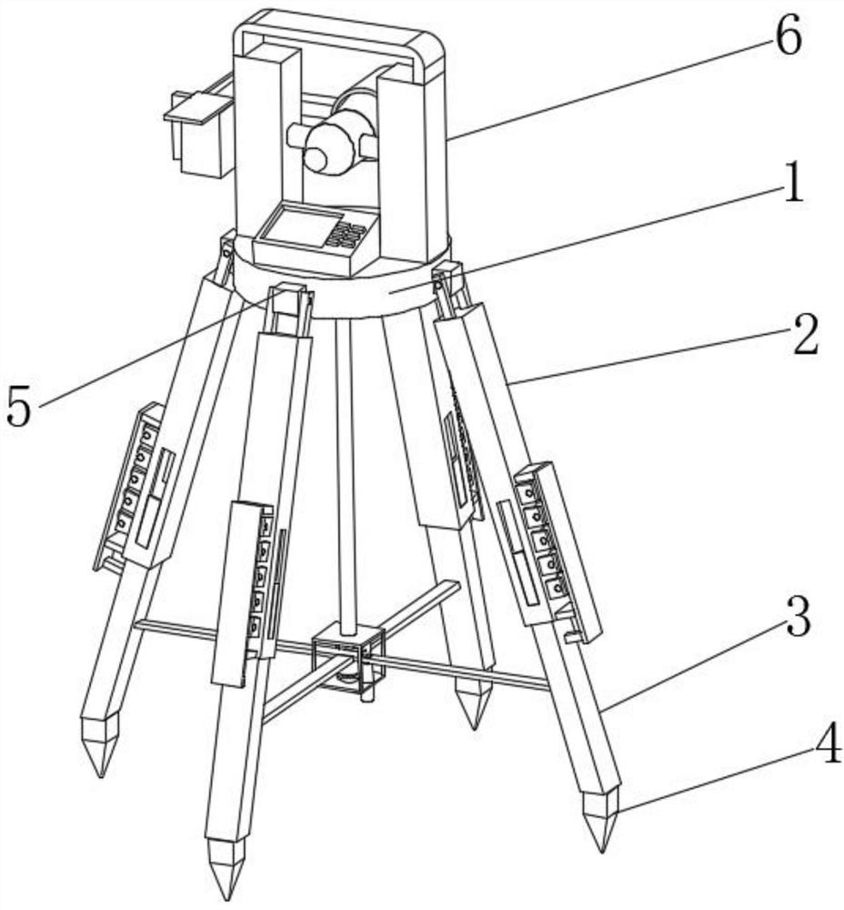
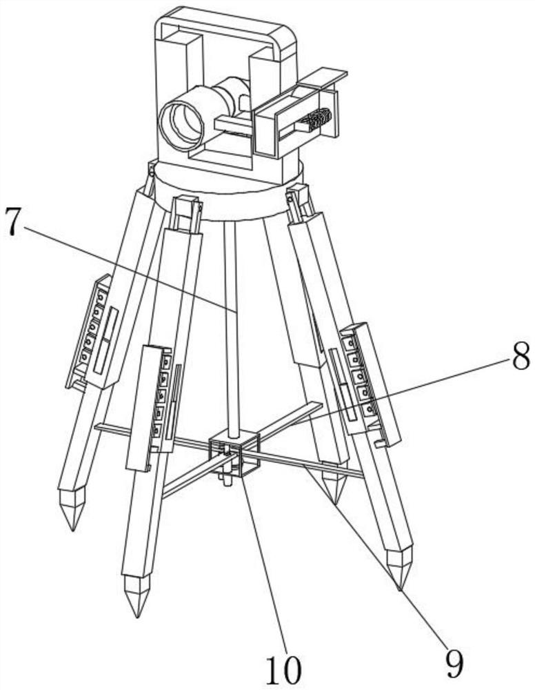
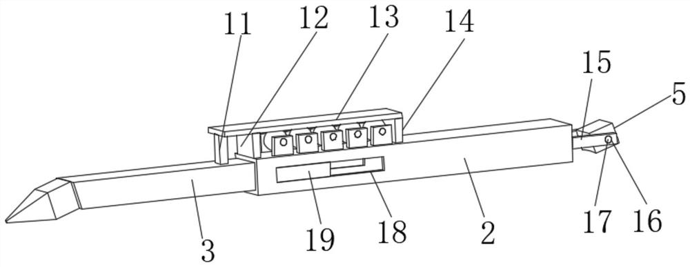
[0026] see Figure 1-8, a surveying and mapping instrument for engineering surveying and mapping, comprising a load-bearing plate 1, a connecting column 7 is fixedly installed on the bottom of the load-bearing plate 1, a connecting frame 10 is fixedly installed on the bottom of the connecting column 7, and a four-corner balancing device is arranged on the bottom end of the connecting frame 10. 32. The four-corner balancing device 32 includes a connecting hemis...


PUM


Abstract

The invention relates to the technical field of engineering surveying and mapping, and discloses an surveying and mapping instrument for engineering surveying and mapping. The instrument comprises a bearing plate, and a connecting column is fixedly mounted at the bottom of the bearing plate. According to the surveying and mapping instrument for engineering surveying and mapping, a lever is formed through the connection relation of the first connecting rod, the second connecting rod and the four-corner balance ball, the supporting rods in the inclined state are subjected to contraction adjustment under the action of the auxiliary balls according to the lever principle, and when the independent supporting rod on one side is subjected to telescopic change, the other three supporting rods can automatically adapt to the change of the inclined supporting rods under the lever action formed by the first connecting rod, the second connecting rod and the four-corner balance ball to keep the overall balance degree of the surveying and mapping instrument; an internal threaded pipe is inserted from a connecting groove formed in the bottom end of the interior of the connecting frame; and the top of the internal threaded pipe is attached to the bottoms of the first connecting rod and the second connecting rod which keep balance, and the device can automatically calibrate balance and is higher in practicability.

Description

technical field [0001] The invention relates to the technical field of engineering surveying and mapping, in particular to a surveying and mapping instrument for engineering surveying and mapping. Background technique [0002] A surveying and mapping instrument is an instrument designed and manufactured for data collection, processing, and output for surveying and mapping operations. Instruments for height, mapping and photogrammetry are installed on a retractable tripod and placed between two observation points, and then the values ​​are obtained through lens observation. [0003] Due to the complex construction environment, the existing surveying and mapping instruments are prone to uneven ground during the use of field surveying and mapping. The uneven ground will cause the surveying and mapping instrument to be tilted as a whole, and the data measured by the inclined surveying and mapping instrument will have errors. And it is artificially unable to effectively calibrat...

Claims


Application Information

Patent Timeline
Patent Type & Authority Applications(China)
IPC IPC(8): G01C15/00
CPCG01C15/00
Inventor 赵子龙刘孝东吴丛丛
Owner 山东标至信土地房地产资产评估测绘有限公司
Why Eureka
Try Eureka