Air-ground integrated accurate range marking method based on GIS (Geographic Information System)

An accurate range, integrated technology, applied in the field of emergency rescue, can solve the problem of inability to obtain precise location, insufficient accuracy, approximate, slow labeling, etc.

Pending Publication Date: 2022-02-15
青岛瑞源工程集团有限公司
View PDF0 Cites 0 Cited by
  • Summary
  • Abstract
  • Description
  • Claims
  • Application Information

AI Technical Summary

Problems solved by technology

However, manually clicking on the map position manually, the labeling is slow and not accurate enough, it is an approximate position, and the precise position cannot be obtained

Method used


Image

  • Air-ground integrated accurate range marking method based on GIS (Geographic Information System)
  • Air-ground integrated accurate range marking method based on GIS (Geographic Information System)
  • Air-ground integrated accurate range marking method based on GIS (Geographic Information System)

Examples


Embodiment Construction

[0024] The following will clearly and completely describe the technical solutions in the embodiments of the present invention with reference to the accompanying drawings in the embodiments of the present invention. Obviously, the described embodiments are only some, not all, embodiments of the present invention. Based on the embodiments of the present invention, all other embodiments obtained by persons of ordinary skill in the art without making creative efforts belong to the protection scope of the present invention.

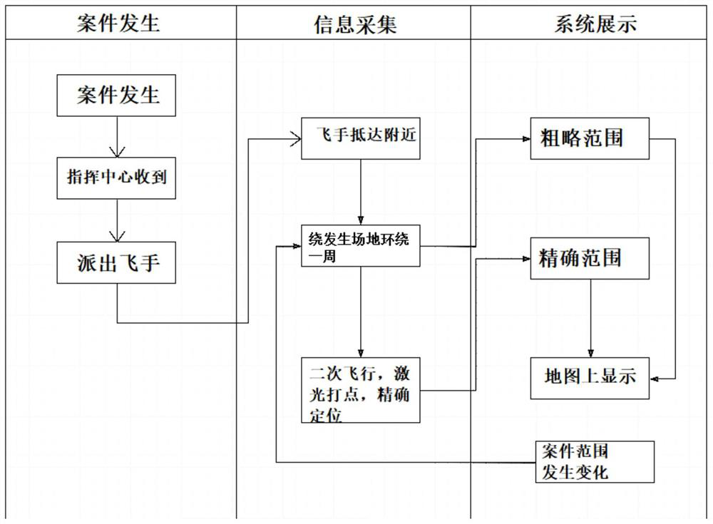
[0025] see Figure 1-3 , a method for GIS-based integrated accurate range labeling of space and ground, comprising the following steps:

[0026] Step 1: When a case occurs, the command center receives the information and assigns the case to the drone pilot;

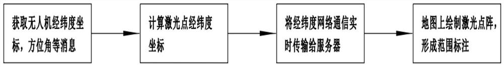
[0027] Step 2: The UAV pilots drive to the vicinity of the scene, take off the UAV, and fly the UAV around the site of the emergency event. The flight trajectory drawn, that is, the rough range, can be u...


PUM


Abstract

The invention discloses an air-ground integrated accurate range marking method based on GIS (Geographic Information System), which comprises the following steps that: 1, when a case occurs, a command center receives information and sends the case to a flying finger of an unmanned aerial vehicle; 2, the unmanned aerial vehicle drives the vehicle to reach the position near the site, the unmanned aerial vehicle takes off, the unmanned aerial vehicle flies around the site where the emergency event occurs, a flight path is drawn, namely a rough range, and at the moment, part of emergency solutions can be designed; 3, the unmanned aerial vehicle pilot continues to control the unmanned aerial vehicle to fly for a second circle, laser ranging is started, and during flying, laser is aligned with the case occurrence range; and 4, atmosphere monitoring micro stations are uniformly deployed in the monitoring range, wherein atmosphere monitoring photosensitive devices and 4G communication modules are arranged in the atmosphere monitoring micro stations. According to the method provided by the invention, the fire behavior range can be quickly marked in the shortest time, so that solution design and command can be quickly carried out; an accurate range is obtained, accurate positioning is achieved, and the fire-fighting unmanned aerial vehicle can be conveniently and accurately taken out.

Description

technical field [0001] The invention relates to the field of emergency rescue, in particular to a GIS-based method for marking the precise range of space and ground integration. Background technique [0002] Fire refers to the disaster caused by burning out of control in time or space. In the new standard, fire is defined as burning out of control in time or space. Among various disasters, fire is one of the main disasters that most frequently and commonly threaten public safety and social development. [0003] When a fire occurs, the leaders and team members of the emergency command center want to obtain the scope of the fire in time and quickly mark it on the map to facilitate the formulation of fire fighting plans, the transfer of personnel and materials, the evacuation of the masses, and emergency rescue. The current implementation plan: the drone flies around the fire, when drawing the range, the drone hovers, and the drawer checks the position of the drone on the map...

Claims


Application Information

Patent Timeline
Patent Type & Authority Applications(China)
IPC IPC(8): G06F16/29
CPCG06F16/29
Inventor 王炳新张明远刘庆彬刘建勋孔锁财张伟
Owner 青岛瑞源工程集团有限公司
Why Eureka
Try Eureka