Terrain data conversion method and device, electronic equipment and storage medium

A terrain data and conversion method technology, applied in the field of surveying and mapping, can solve the problems of high data storage cost, low transmission efficiency, and large volume of terrain data files, and achieve the effects of reducing storage costs, improving transmission efficiency, and reducing file size

Pending Publication Date: 2022-03-25
GUANGZHOU XAIRCRAFT TECH CO LTD
View PDF0 Cites 0 Cited by
  • Summary
  • Abstract
  • Description
  • Claims
  • Application Information

AI Technical Summary

Problems solved by technology

[0005] In view of this, the object of the present invention is to provide a terrain data conversion method, device, electronic equipment and storage medium

Method used


Image

  • Terrain data conversion method and device, electronic equipment and storage medium
  • Terrain data conversion method and device, electronic equipment and storage medium
  • Terrain data conversion method and device, electronic equipment and storage medium

Examples


Example Embodiment

[0045] The technical solutions in the embodiments of the present invention will be clearly and completely described below with reference to the accompanying drawings in the embodiments of the present invention. Obviously, the described embodiments are only a part of the embodiments of the present invention, rather than all the embodiments. The components of the embodiments of the invention generally described and illustrated in the drawings herein may be arranged and designed in a variety of different configurations.

[0046] Thus, the following detailed description of the embodiments of the invention provided in the accompanying drawings are not intended to limit the scope of the invention as claimed, but are merely representative of selected embodiments of the invention. Based on the embodiments of the present invention, all other embodiments obtained by those skilled in the art without creative work fall within the protection scope of the present invention.

[0047]It shoul...


PUM


Abstract

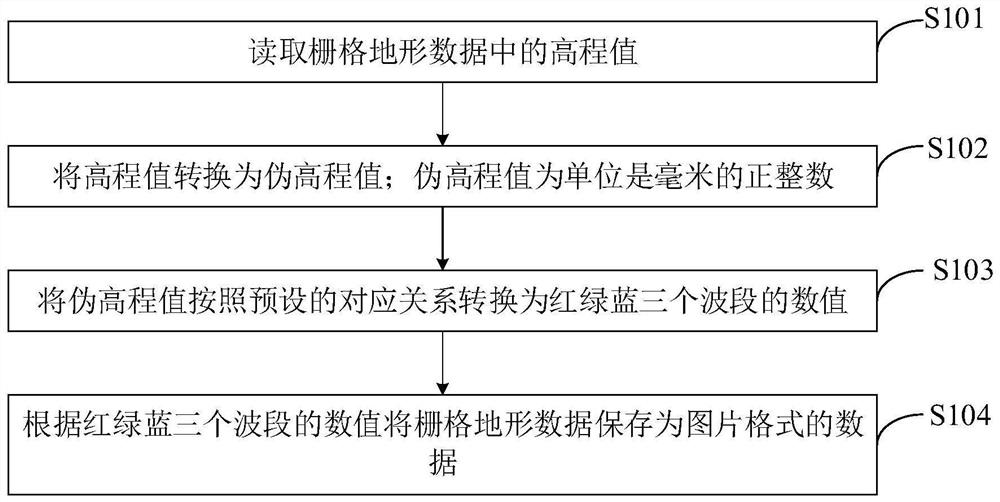
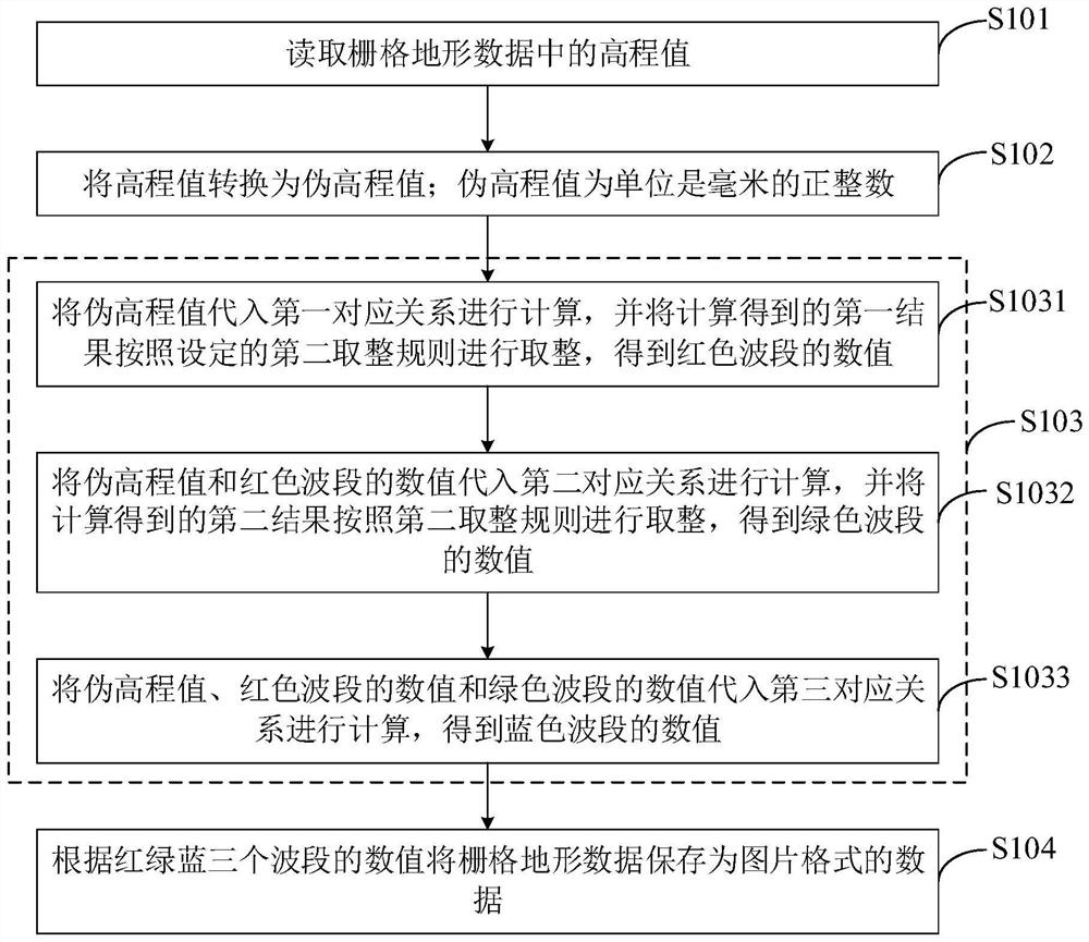
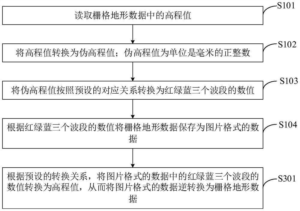
The embodiment of the invention provides a topographic data conversion method and device, electronic equipment and a storage medium, and relates to the field of surveying and mapping. The method comprises the following steps: reading an elevation value in grid topographic data, converting the elevation value into a pseudo-elevation value of which the unit is millimeter and is a positive integer, converting the pseudo-elevation value into numerical values of red, green and blue wavebands according to a preset corresponding relation, and then storing the grid topographic data as data in a picture format according to the numerical values of the red, green and blue wavebands. Therefore, the raster topographic data is converted into the data in the picture format at the millimeter-level precision, and lossless compression can be performed on the raster topographic data by using the lossless compression technology of the picture format, so that the file size of the raster topographic data is effectively reduced, the storage cost of the data is reduced, and the transmission efficiency of the data is improved.

Description

technical field [0001] The present invention relates to the field of surveying and mapping, in particular to a terrain data conversion method, device, electronic equipment and storage medium. Background technique [0002] In the surveying and mapping industry, aerial photogrammetry results usually record the terrain fluctuations in the surveying area with single-band raster images. The most common raster digital terrain models are DSM (Digital Surface Model, Digital Surface Model) and DEM (Digital Elevation Model, digital elevation model), usually stores data in GeoTiff file format. [0003] DSM refers to the ground elevation model that includes the height of surface buildings, bridges and trees. DEM is a digital simulation of ground terrain through limited terrain elevation data (that is, the digital expression of terrain surface morphology). It is a solid ground model that uses a set of ordered numerical arrays to represent ground elevation. TerrainModel, a branch of dig...

Claims


Application Information

Patent Timeline
IPC IPC(8): G06F16/25G06F16/22G06F16/29
CPCG06F16/258G06F16/2291G06F16/29
Inventor 冯肇勇
Owner GUANGZHOU XAIRCRAFT TECH CO LTD
Why Eureka
Try Eureka