Navigation enhancement display method based on high-precision map and automobile

A technology that enhances display and maps, and is applied in navigation, surveying and navigation, road network navigators, etc., and can solve problems such as underutilization of high-precision map devices and visual sensors

Pending Publication Date: 2022-04-15
CHONGQING CHANGAN AUTOMOBILE CO LTD
View PDF0 Cites 0 Cited by
  • Summary
  • Abstract
  • Description
  • Claims
  • Application Information

AI Technical Summary

Problems solved by technology

When the driver is not using the driving assistance function, the hi

Method used


Image

  • Navigation enhancement display method based on high-precision map and automobile
  • Navigation enhancement display method based on high-precision map and automobile
  • Navigation enhancement display method based on high-precision map and automobile

Examples


Embodiment Construction

[0024] Below in conjunction with accompanying drawing, the present invention is further described:

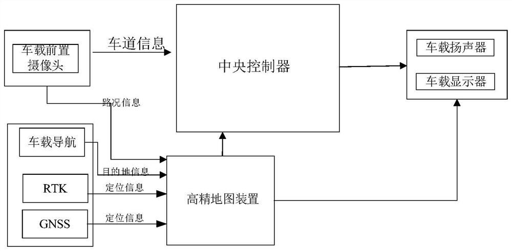
[0025] The present invention provides a high-precision map-based navigation enhanced display device, which includes:

[0026] Central controller; steering wheel buttons, vehicle front camera, vehicle navigation, high-precision map device, vehicle positioning instrument, vehicle display and vehicle speaker respectively connected with the central controller. The front camera on the vehicle outputs the front road condition information within the first predetermined distance in front of the vehicle to the central controller, and provides the front road condition information within the first predetermined distance in front of the vehicle to the high-precision map device. The vehicle navigation is used for the driver to set the destination, and the vehicle positioning instrument (RTK and GNSS) is used to provide real-time vehicle positioning information to the high-precision map devi...


PUM


Abstract

The invention provides a navigation enhancement display method based on a high-precision map device, which is applied to a navigation enhancement display system, and the navigation enhancement display system comprises a central controller; the steering wheel key, the vehicle-mounted front camera, the vehicle-mounted navigator, the high-precision map device, the vehicle-mounted positioning instrument, the vehicle-mounted display and the vehicle-mounted loudspeaker are respectively connected with the central controller; and the vehicle-mounted front camera, the vehicle-mounted navigator and the vehicle-mounted positioning instrument are respectively connected with the high-precision map device.

Description

technical field [0001] The invention belongs to the field of automobile safety driving, and in particular relates to a high-precision map-based navigation augmented reality method and an automobile. Background technique [0002] At present, driver assistance systems mainly rely on millimeter-wave radar and cameras to identify lane lines and vehicle information to achieve acceleration and deceleration and lateral control in a single lane. The car navigation mainly gives the route and prompt information of the standard working condition. Some driving assistance vehicles are equipped with ADAS maps, which can provide information such as road types, curves, ramps, etc., and assist the driving assistance system in speed control, but lane-level positioning cannot be performed due to accuracy reasons. [0003] With the emergence of high-precision maps, the horizontal accuracy reaches centimeter level, which can realize lane-level positioning and more accurate scene reconstruction....

Claims


Application Information

Patent Timeline
IPC IPC(8): G05D1/02G01C21/30G01C21/36
CPCG05D1/0223G05D1/0246G01C21/30G01C21/3658G05D2201/0212
Inventor 凌洪清卢斌
Owner CHONGQING CHANGAN AUTOMOBILE CO LTD
Why Eureka
Try Eureka