Path planning method, device, controller and storage medium for unmanned aerial vehicle swarm

A technology for path planning and drones, applied in the field of drones, to improve coverage accuracy, reduce power consumption, and achieve accurate identification and positioning.

Active Publication Date: 2022-07-08
北京卓翼智能科技有限公司
View PDF7 Cites 0 Cited by
  • Summary
  • Abstract
  • Description
  • Claims
  • Application Information

AI Technical Summary

Problems solved by technology

Field of view is an important factor to consider when solving UAV coverage optimization problems, and existing monitoring methods do not adequately respond to this factor

Method used


Image

  • Path planning method, device, controller and storage medium for unmanned aerial vehicle swarm
  • Path planning method, device, controller and storage medium for unmanned aerial vehicle swarm
  • Path planning method, device, controller and storage medium for unmanned aerial vehicle swarm

Examples


Embodiment Construction

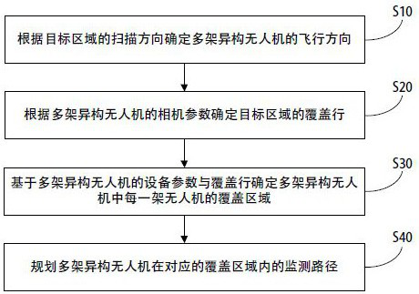
[0103] In order to further illustrate the technical means and effects adopted by the present invention to achieve the predetermined purpose of the invention, the following describes a path planning method for an unmanned aerial vehicle swarm and an unmanned aerial vehicle swarm according to the present invention with reference to the accompanying drawings and preferred embodiments. The specific implementations of the path planning device, the controller and the computer-readable storage medium and their effects are described in detail as follows.

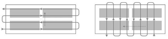
[0104]In order to make a group of UAVs with different camera field of view, flight speed and remaining battery power, that is, a heterogeneous UAV swarm, can cover the specified target area in the shortest time, the present invention combines the traditional vehicle routing problem (vehicle routing problem). routing problem, VRP) into a mixed integer linear program (MILP), and the performance of the proposed VRP solution is verified ...


PUM


Abstract

The invention discloses a path planning method, device, controller and storage medium for an unmanned aerial vehicle swarm, wherein the method comprises: determining the flying direction of multiple heterogeneous unmanned aerial vehicles according to the scanning direction of a target area; Determine the coverage line of the target area based on the camera parameters of the UAV; determine the coverage area of ​​each UAV in the multiple heterogeneous UAVs based on the equipment parameters and coverage lines of multiple heterogeneous UAVs; plan multiple UAVs Monitoring paths of heterogeneous UAVs in the corresponding coverage area. The invention realizes that the heterogeneous unmanned aerial vehicle group can complete the complete coverage of the designated area in the shortest time, and realizes the accurate identification and positioning of the monitoring of the target area.

Description

technical field [0001] The present invention relates to the technical field of unmanned aerial vehicles, in particular to a path planning method for an unmanned aerial vehicle swarm, a path planning device for an unmanned aerial vehicle swarm, a controller and a computer-readable storage medium. Background technique [0002] The traditional census monitoring of pests and diseases mainly adopts the monitoring methods of manual inspection or remote sensing image or manned aircraft survey. The manual inspection method is labor-intensive, time-consuming, and inefficient, and there is also the problem that the technical level of the inspectors is high or low, which leads to inaccurate information acquisition of forestry resources. In addition, with the increase of labor costs, the cost also increases. In addition, the terrain and landforms of forest areas are steep and the epidemic of pine wood nematodes spreads rapidly. The high-altitude remote sensing image monitoring method i...

Claims


Application Information

Patent Timeline
Patent Type & Authority Patents(China)
IPC IPC(8): G05D1/10
Inventor 罗巍任雪峰
Owner 北京卓翼智能科技有限公司
Why Eureka
Try Eureka