
Special landform distribution range identification method, device and equipment

A technology of distribution range and recognition method, which is applied in the directions of character and pattern recognition, image analysis, image data processing, etc., can solve problems such as unrealizable, irregular geometric shape, and complex spatial distribution, and achieve good recognition effect

Pending Publication Date: 2022-04-15
BEIJING SATELLITE INFORMATION ENG RES INST
View PDF0 Cites 4 Cited by
  • Summary
  • Abstract
  • Description
  • Claims
  • Application Information

AI Technical Summary

Problems solved by technology

[0004] The space-to-earth observation technology with satellite remote sensing as the core is a technical means that can comprehensively and accurately extract various geomorphic features. However, according to the above, due to the geometric irregularity and spatial distribution The complexity of the karst landform, coupled with the dense vegetation coverage in the southern karst region, has brought great challenges to the use of satellite remote sensing images to extract the morphological characteristics and spatial distribution information of large-scale karst landforms with high precision and high efficiency.
In addition, a complete karst landform system should include ground cones and karst plains (or karst depressions, funnels, etc.) Therefore, it is not possible to achieve the desired effect by simply relying on the spectral information contained in remote sensing images for classification.

Method used


Image

  • Special landform distribution range identification method, device and equipment
  • Special landform distribution range identification method, device and equipment
  • Special landform distribution range identification method, device and equipment

Examples


Embodiment Construction

[0039] In order to more clearly describe the embodiments of the present invention or the technical solutions in the prior art, the following will briefly introduce the drawings that are used in the embodiments. Apparently, the drawings in the following description are only some embodiments of the present invention, and those skilled in the art can also obtain other drawings according to these drawings without creative efforts.

[0040] The present invention will be described in detail below in conjunction with the accompanying drawings and specific embodiments, and the embodiments cannot be repeated here one by one, but the embodiments of the present invention are not therefore limited to the following embodiments.

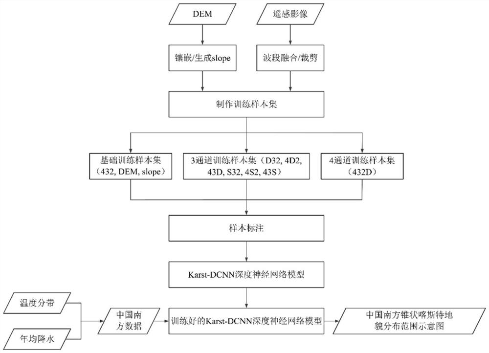
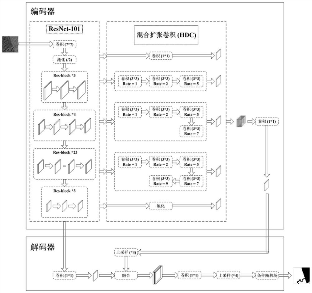
[0041] see figure 1 , the special landform distribution range identification method of the present invention belongs to the space earth observation technology with satellite remote sensing as the core, specifically an automatic information extraction method for re...


PUM


Abstract

The invention relates to a special landform distribution range identification method, device and equipment, and the method comprises the following steps: a, obtaining an optical remote sensing image and elevation data of a region with a special landform, and carrying out the preprocessing; b, generating gradient data based on the elevation data, and fusing the optical remote sensing image, the elevation data and the gradient data to obtain a training sample; c, labeling the training sample to obtain a label file, and training the recognition model by using the training sample and the label file; d, acquiring an optical remote sensing image and elevation data of a to-be-identified area, and performing fusion cutting to obtain to-be-identified data; and e, identifying the to-be-identified data by using the identification model to obtain the special landform distribution range of the to-be-identified area. According to the method, automatic identification and accurate extraction of the spatial distribution range of special landscapes such as the conical karst landform can be realized.

Description

technical field [0001] The invention relates to a method, device and equipment for identifying the distribution range of special landforms. Background technique [0002] Karst landscape is a relatively prominent geological landscape on the earth, and there are different types and forms of karst landforms distributed all over the world. The formation of karst landforms is closely related to geological tectonic movements. Most of the karst areas are exposed to soluble carbonate rocks. There are many remarkable karst landscapes such as karst, tiankeng karst, tower karst and canyon karst, so it has extremely high scientific research value. Among them, the cone-shaped karst landform has typical two-slope symmetry, cone peaks with rounded cones, and rich positive and negative landform combinations, including peak-cong depressions and peak-cong valleys. Some typical cone-shaped karst landforms (Libo, Guizhou) include two independent areas with a huge buffer area, and some areas h...

Claims


Application Information

Patent Timeline
IPC IPC(8): G06V20/10G06T7/90G06K9/62G06T7/11G06V10/774G06N3/04
Inventor 符晗常江贺广均冯鹏铭刘世烁金世超石慧峰杨志才
Owner BEIJING SATELLITE INFORMATION ENG RES INST
Learn More