Crop drawing method using Sentinel-2 time sequence image data

A technology of image data and time series, which is applied in the field of agricultural remote sensing, can solve the problems of limiting the practical application of satellite images, short revisit period, crop targets cannot be recorded by satellite, etc., and achieve accurate corn stalk reserve estimation and detailed spatial details Effect

Pending Publication Date: 2022-05-20
国能生物发电集团有限公司 +1
View PDF0 Cites 5 Cited by
  • Summary
  • Abstract
  • Description
  • Claims
  • Application Information

AI Technical Summary

Problems solved by technology

[0004] In fact, no matter which data source is used, the existence of clouds and fog will seriously affect the imaging quality of remote sensing images, resulting in the failure of crop targets to be recorded by satellites, which seriously limits the practical application of satellite imagery for crop mapping
On the other hand, due to the higher resolution of Sentinel-2 remote sensing data and the shorter revisit period, in order to make full use of the information of each pixel, it is bound to bring a huge amount of data, which has a great impact on data storage, call and calculation. come to great challenge

Method used


Image

  • Crop drawing method using Sentinel-2 time sequence image data
  • Crop drawing method using Sentinel-2 time sequence image data
  • Crop drawing method using Sentinel-2 time sequence image data

Examples


Embodiment Construction

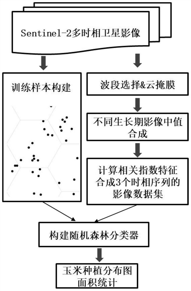
[0035] The present invention provides a crop mapping method using Sentinel-2 time series image data. The technical solution of the present invention will be further described below in conjunction with the accompanying drawings and embodiments.

[0036] Such as figure 1 As shown, the process of the embodiment of the present invention includes the following steps:

[0037] Step 1. Determine the study area and the time range of Sentinel-2 satellite images to be acquired.

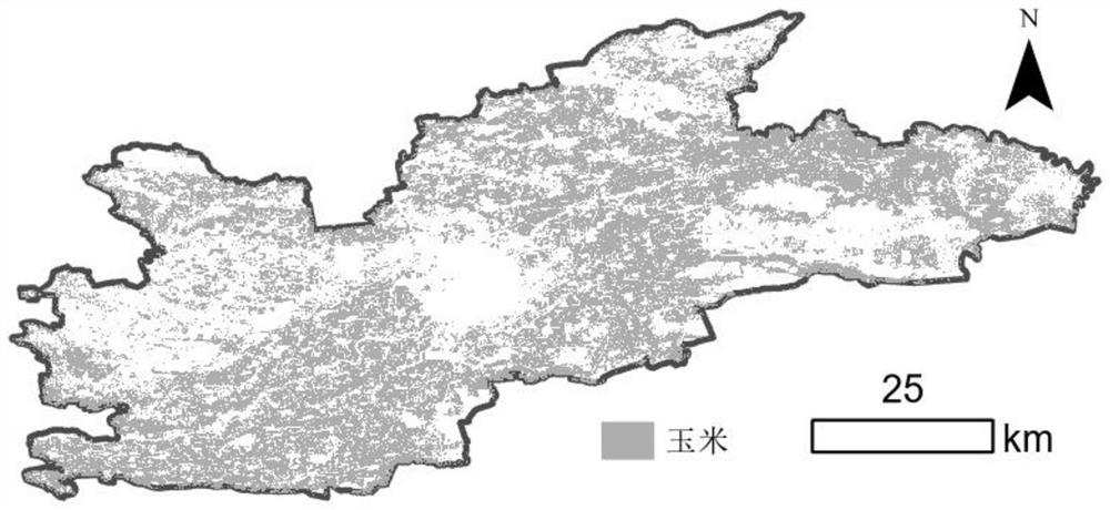
[0038]In this example, Horqin District, Tongliao City, Inner Mongolia Autonomous Region, my country is the main research area, and the time range is selected from March 1, 2021 to September 10, 2021, covering the main phenological periods of corn growth in Tongliao. The remote sensing images are All available Sentinel-2 satellite imagery data covering the study area.

[0039] Step 2, preprocessing the Sentinel-2 satellite images screened in step 1.

[0040] Select the L2A level reflectance data of Sentinel-2 ...


PUM


Abstract

The invention relates to a crop drawing method using Sentinel-2 time sequence image data. The method comprises the following steps: firstly, carrying out wave band selection and cloud mask pretreatment on an image in a research area, then generating an image data set synthesized according to corn growth stages according to a corn growth phenology law, calculating a normalized vegetation index and a normalized moisture index, adding the normalized vegetation index and the normalized moisture index into wave bands of the image, and then creating sample points of the research area; and forming a sample pair with the image data set at the corresponding position, training the classification model by using a random forest algorithm, finally obtaining a distribution diagram of the corn in the research area by using the trained classification model, and performing pixel-by-pixel summary statistics to obtain the corn planting area in the research area. According to the method, a GoogleEarthEngine cloud platform is utilized to realize storage and calculation of a large amount of data, a method of performing median synthesis according to growth stages is designed to reduce the influence caused by cloud pollution to the greatest extent, and finally, fine mapping and area monitoring of corn are quickly realized.

Description

technical field [0001] The invention belongs to the technical field of agricultural remote sensing, and in particular relates to a crop mapping method using Sentinel-2 time series image data. Background technique [0002] my country is a large agricultural country. As one of the most important food crops, corn is not only crucial to ensuring national food security, but also the corn stalks produced after harvesting are also an important biomass resource. In the context of global warming, the reduction of carbon emissions has been brought to an unprecedented height by our country. The use of corn stalks for biomass power generation is very important for replacing or partially replacing fossil energy, protecting the ecological environment, and realizing the sustainable development of human society. important practical and long-term significance. However, there is still a lack of understanding of the reserves and distribution of corn stalks. The use of remote sensing technolog...

Claims


Application Information

Patent Timeline
Patent Type & Authority Applications(China)
IPC IPC(8): G06V20/13G06V10/774G06V10/764G06K9/62
CPCG06F18/24323G06F18/214
Inventor 朱建军张洪艳张雁茹柳向宇王振江祁晓乐苗青
Owner 国能生物发电集团有限公司
Why Eureka
Try Eureka