Surveying and mapping device for urban and rural road planning

A technology of surveying and mapping devices and roads, which is applied in the direction of measuring devices, mechanical measuring devices, and mechanical devices, etc., can solve problems such as counter damage and inability to count, and achieve the effect of avoiding rolling

Active Publication Date: 2022-07-01
山东富源勘察测绘设计有限公司 +2
View PDF12 Cites 5 Cited by
  • Summary
  • Abstract
  • Description
  • Claims
  • Application Information

AI Technical Summary

Problems solved by technology

[0004] Aiming at the deficiencies of the prior art, the present invention provides a surveying and mapping device for urban and rural road planning, which solves the problem that the existing distance measuring wheel cannot count if the counter is damaged during the walking process

Method used


Image

  • Surveying and mapping device for urban and rural road planning
  • Surveying and mapping device for urban and rural road planning
  • Surveying and mapping device for urban and rural road planning

Examples


Embodiment Construction

[0034] The technical solutions in the embodiments of the present invention will be clearly and completely described below with reference to the accompanying drawings in the embodiments of the present invention.

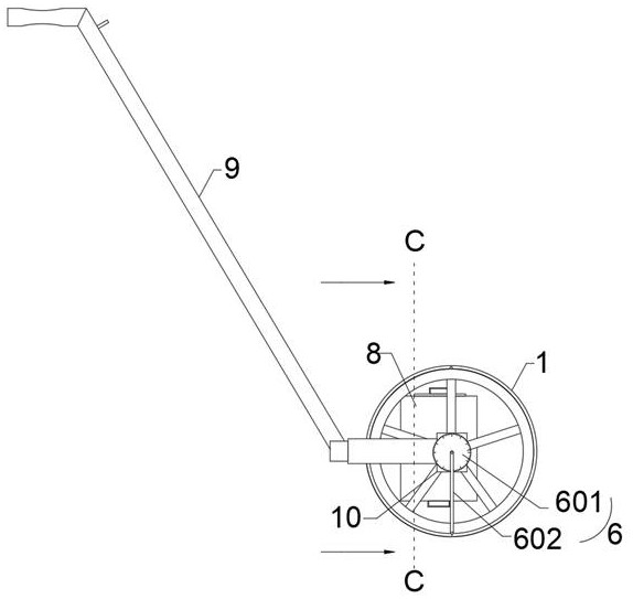
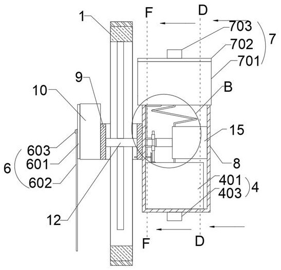
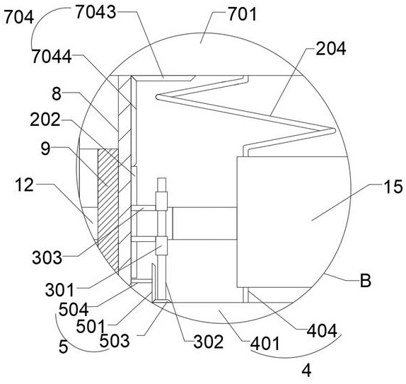
[0035] Please see attached Figure 1-13 , a surveying and mapping device for urban and rural road planning, comprising a distance measuring wheel 1, a mounting frame 9 located outside the distance measuring wheel 1, a rotating shaft 12 located in the distance measuring wheel 1 and a counter 10 on one side of the distance measuring wheel 1, the mounting frame 9. An installation casing 8 is provided on one side, and one end of the rotating shaft 12 is located in the installation casing 8 and is rotatably connected with the installation casing 8. The inner wall of the installation casing 8 is fixedly connected with a fixed casing 15, and the installation casing 8 is provided with a rotating Mechanism 2, the rotating mechanism 2 includes a spiral tube 204, a turntable 205...


PUM


Abstract

The invention relates to the technical field of road planning, and discloses a surveying and mapping device for urban and rural road planning, which comprises a distance measuring wheel, a mounting frame positioned on the outer side of the distance measuring wheel, a rotating shaft positioned in the distance measuring wheel and a counter positioned on one side of the distance measuring wheel, the second gear is arranged on one side of the first gear at one end of the rotating shaft, the rotating disc is fixedly connected to the center shaft of the second gear, and the groove in the rotating disc communicates with the spiral pipe and the connecting pipe in the moving process, so that in the walking process of the distance measuring wheel, the weighing balls can be conveyed at the same time, and the situation that a counter is damaged and cannot count is avoided; the counting marks are arranged on the outer side of the distance measuring wheel, the arrowhead rotating rod corresponding to the counting marks is rotationally connected to the connecting shaft on one side of the counter, the dial is fixedly arranged on the outer side of the connecting shaft in a sleeving mode, and if the last measured circle is not an integer circle, accurate measurement can be conducted.

Description

technical field [0001] The invention relates to the technical field of road planning, in particular to a surveying and mapping device for urban and rural road planning. Background technique [0002] Road network planning refers to the systematic planning work on the route location, technical level, scheme comparison, investment benefit and realization period of the main and branch roads of the road network on the basis of traffic planning. [0003] When the existing distance measuring wheel used for road planning is in use, if the counter used for counting is damaged next to it, the staff needs to replace the distance measuring wheel and re-measure the delay time. SUMMARY OF THE INVENTION [0004] Aiming at the deficiencies of the prior art, the present invention provides a surveying and mapping device for urban and rural road planning, which solves the problem that the counter cannot be counted if the counter is damaged during the walking process of the existing distance ...

Claims


Application Information

Patent Timeline
Patent Type & Authority Applications(China)
IPC IPC(8): G01C22/00G01B5/14G01B5/00
CPCG01C22/00G01B5/14G01B5/0002
Inventor 张宣峰韩伦宋艳李彬段升伟
Owner 山东富源勘察测绘设计有限公司
Why Eureka
Try Eureka