Flood range monitoring method based on GNSS-R
A range and flood technology, which is applied in the field of flood range monitoring based on GNSS-R, can solve the problems of inability to identify water bodies, the influence of optical remote sensing, and the long revisit period of microwave remote sensing satellites, so as to achieve the effect of short revisit period and low cost.
Pending Publication Date: 2022-07-22
CHANGAN UNIV
View PDF0 Cites 0 Cited by
- Summary
- Abstract
- Description
- Claims
- Application Information
AI Technical Summary
Problems solved by technology
[0004] However, optical remote sensing is easily affected by clouds and cannot identify water bodies under tree canopies, which is very unfavorable for monitoring floods caused by rainfall; although microwave frequencies can penetrate clouds, the revisit period of microwave remote sensing satellites is long. It cannot fully and dynamically capture the range of floods over time, and is easily affected by buildings, forest cover, etc.
Method used
View moreImage
Smart ImageViewing Examples
Examples
Embodiment
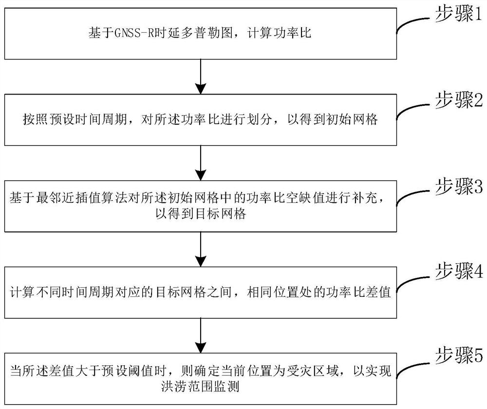
[0028] See figure 1 , figure 1 It is a schematic diagram of a GNSS-R-based flood range monitoring method provided by an embodiment of the present invention, and the method includes:
[0029] Step 1: Calculate the power ratio based on the GNSS-R delay Doppler map.
Login to View More PUM
 Abstract
The invention discloses a GNSS-R-based flood range monitoring method, and the method comprises the steps: calculating a power ratio based on a GNSS-R time delay Doppler diagram; dividing the power ratio according to a preset time period to obtain an initial grid; supplementing the power ratio vacancy value in the initial grid based on a nearest neighbor interpolation algorithm to obtain a target grid; calculating a power ratio difference value between the target grids corresponding to different time periods and at the same position; and when the difference value is greater than a preset threshold value, determining that the current position is a disaster-affected area so as to realize flood range monitoring. According to the invention, the dynamic change of the flood range can be monitored, the overall disaster range before and after flood occurrence can be effectively estimated, and flood monitoring can be carried out according to the preset time period, i.e., the preset time resolution; the problem that in the prior art, optical remote sensing and microwave remote sensing are insufficient in time resolution in the aspect of flood monitoring is solved.
Description
technical field [0001] The invention belongs to the field of signal processing, and in particular relates to a method for monitoring a flood area based on GNSS-R. Background technique [0002] Of all social natural disasters, floods are the most destructive, frequent and widespread. Flooding caused by excessive rainfall in a short period of time is a common disaster in the Asian monsoon region. Especially for cities, due to dense population and developed economy, floods caused by heavy rainfall will cause greater economic losses and casualties. [0003] In the prior art, people usually use optical remote sensing and microwave remote sensing to draw flood disaster maps to help emergency management during disasters and reconstruction after disasters. [0004] However, optical remote sensing is easily affected by clouds and cannot identify water bodies under tree canopies, which is very unfavorable for monitoring floods caused by rainfall; although microwave frequencies can p...
Claims
Login to View More Application Information
Patent Timeline
 Patent Type & Authority Applications(China)
IPC IPC(8): G01S19/37G01S19/14
CPCG01S19/37G01S19/14
Inventor 胡羽丰汪吉李振洪
Owner CHANGAN UNIV
Features
- R&D
- Intellectual Property
- Life Sciences
- Materials
- Tech Scout
- Unparalleled Data Quality
- Higher Quality Content
- 60% Fewer Hallucinations
Learn More Browse by: Latest US Patents, China's latest patents, Technical Efficacy Thesaurus, Application Domain, Technology Topic, Popular Technical Reports.
© 2025 PatSnap. All rights reserved.Legal|Privacy policy|Modern Slavery Act Transparency Statement|Sitemap|About US| Contact US: help@patsnap.com


