Method for registration of web covering service coordinate based on web map service

A technology of coordinates and maps, applied in the cross field of geographic information Web service technology, can solve the problems of immature integration technology that cannot be transformed into the same, multi-protocol geographic information service, and achieve the effect of simple method and high execution efficiency.

Inactive Publication Date: 2006-06-14
WUHAN UNIV
View PDF0 Cites 9 Cited by
  • Summary
  • Abstract
  • Description
  • Claims
  • Application Information

AI Technical Summary

Problems solved by technology

[0006] At present, the integration technology of multi-protocol geographic information services is still immature. The main reasons include: when various geographic information services do not have a common reference coordinate system, it is impossible to integrate WFS service data, WCS service data, WMS service data are transformed into the same

Method used


Image

  • Method for registration of web covering service coordinate based on web map service
  • Method for registration of web covering service coordinate based on web map service

Examples


Embodiment Construction

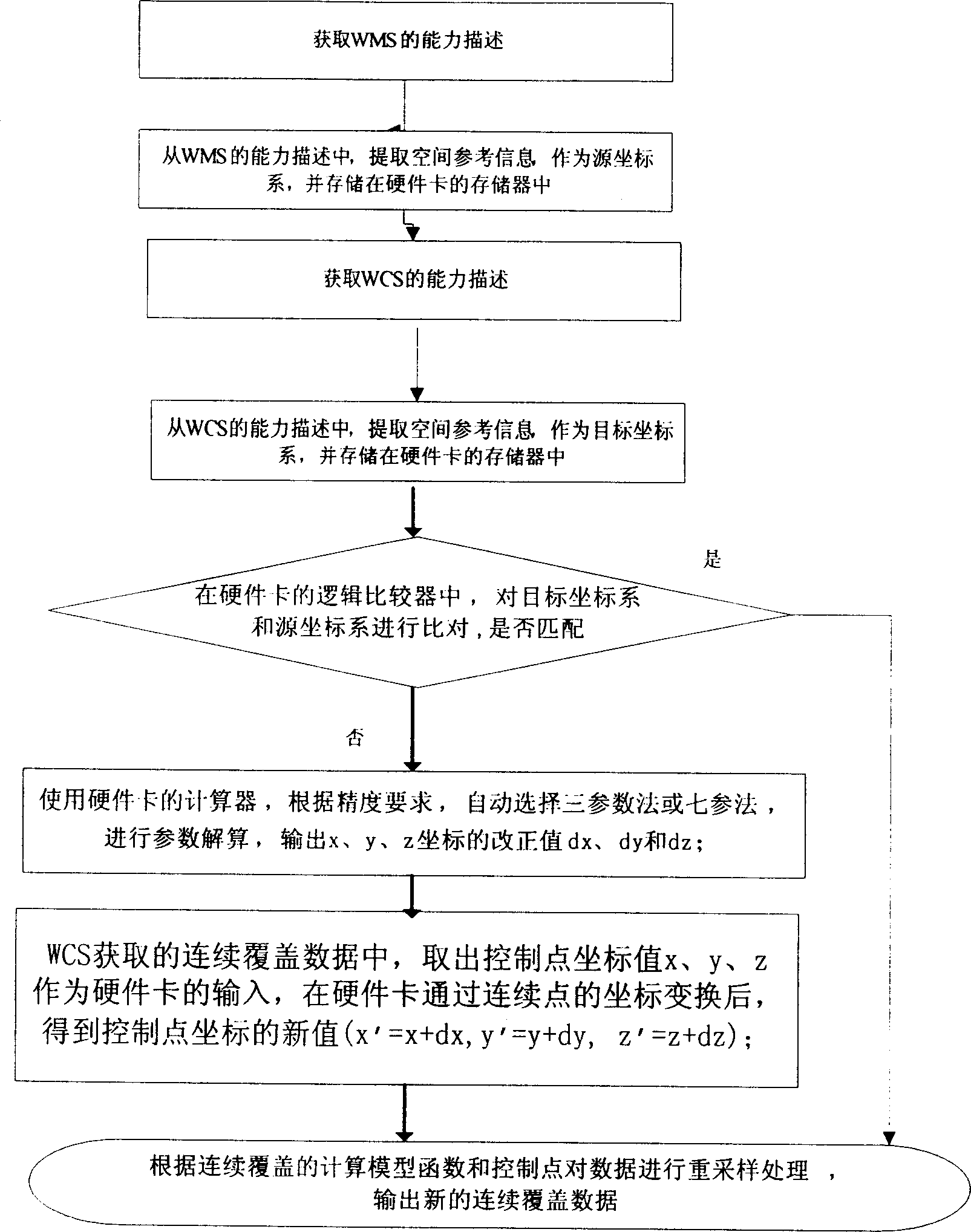
[0028] Such as figure 1 The shown embodiment of the method of the present invention, the coordinate registration method of the Web coverage service based on the Web map service, is characterized in that: it includes:

[0029] (1) A step for storing the value of the spatial reference of the WMS as a source coordinate system parameter in memory.

[0030] (2) A step for storing the value of the spatial reference obtained from the capability description of the WCS in the memory as the parameter of the target coordinate system.

[0031] A step for comparing the parameters of the target coordinate system with the parameters of the source coordinate system. This step can choose the following actions:

[0032] The parameters of the target coordinate system match the parameters of the source coordinate system, and end the following steps;

[0033] Or the parameters of the target coordinate system do not match the parameters of the source coordinate system, go to step (3).

[0034] (...


PUM


Abstract

This invention relates to a configuration method for the Web covering service coordinate based on the Web map service, which applies the conversion mode of continuous points by taking the reference coordinate supported by the WMS service end as the primary standard to convert WCS service data under different reference systems to the reference coordinate system with the same data to WMS service and bring the geographical data got from the geographical service information of different protocols into a unified frame to integrate multi-protocol geographical service from different stops, plants, services, data sources and different space reference systems on the browser.

Description

technical field [0001] The invention relates to a network geographic information service system, in particular to the interdisciplinary field of geographic information Web service technology, in particular to a method for realizing sharing and integration between geographic information services of different protocols. Background technique [0002] It can be predicted that with the development of geographic information services, how to realize the sharing and integration of geographic information services of different protocols will become an urgent problem in the field of geographic information. [0003] Currently, the OGC Web Service Working Group is working on establishing a Web service standard for open geographic information, with the aim of proposing an evolvable, standards-based framework that can seamlessly integrate various online spatial processing and location services, that is, OWS (OGC Web Services), which enables distributed spatial processing systems to interac...

Claims


Application Information

Patent Timeline
IPC IPC(8): H04L29/06
Inventor 陈能成龚健雅高升吴德福
Owner WUHAN UNIV
Why Eureka
Try Eureka