Enhancing temporal and spatial resolution and correcting data anomalies of remote sensed data for estimating high spatio-temporal resolution vegetation indices

a technology of vegetation index and spatial resolution, applied in image enhancement, image analysis, instruments, etc., can solve the problems of low temporal and/or spatial resolution of satellite data, drones generally require technical expertise, and spatial resolution does not match across various satellites, so as to achieve high spatio-temporal resolution and enhance temporal and spatial resolution

Active Publication Date: 2021-02-09
INT BUSINESS MASCH CORP
View PDF4 Cites 2 Cited by
  • Summary
  • Abstract
  • Description
  • Claims
  • Application Information

AI Technical Summary

Benefits of technology

[0004]In aspects, a virtual satellite apparatus and method may be provided, which correct data anomalies of remote sensed data and enhances temporal and spatial resolution, for instance, to estimate high spatio-temporal resolution vegetation indices termed as High Definition Normalized Difference Vegetation Index (HD-NDVI).

Problems solved by technology

A challenge, however, in using the data from multiple satellites to derive common integrated insight is that the spatial and temporal resolutions do not match across various satellites.
In another aspect, satellite data is available at low temporal and / or spatial resolution and is affected by atmospheric interference and cloud cover.
While drones with specialized near-infrared (NIR) cameras and corresponding image processing algorithms can also identify crop growth stages, drones generally require technical expertise, high operating expense and investment, and permission from local authorities to operate.

Method used


Image

  • Enhancing temporal and spatial resolution and correcting data anomalies of remote sensed data for estimating high spatio-temporal resolution vegetation indices
  • Enhancing temporal and spatial resolution and correcting data anomalies of remote sensed data for estimating high spatio-temporal resolution vegetation indices
  • Enhancing temporal and spatial resolution and correcting data anomalies of remote sensed data for estimating high spatio-temporal resolution vegetation indices

Examples


Embodiment Construction

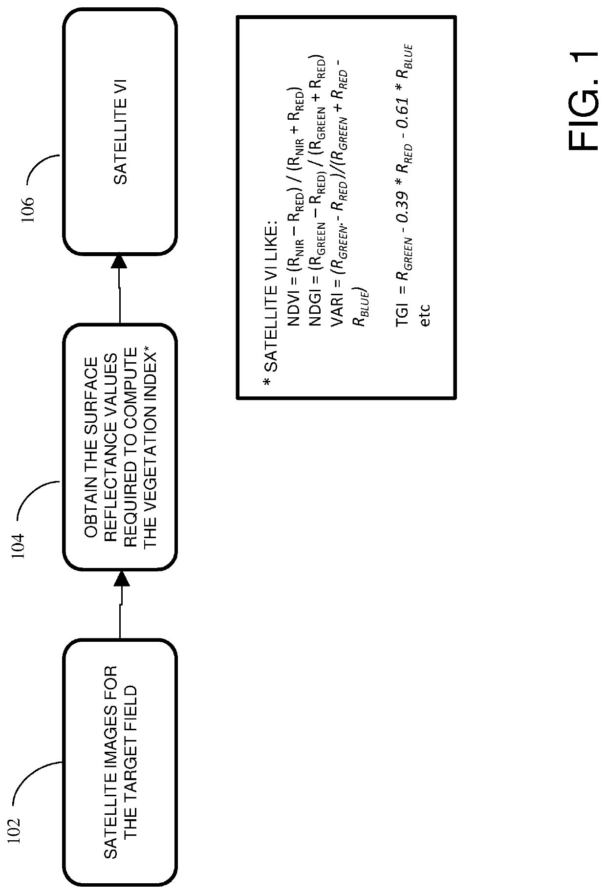
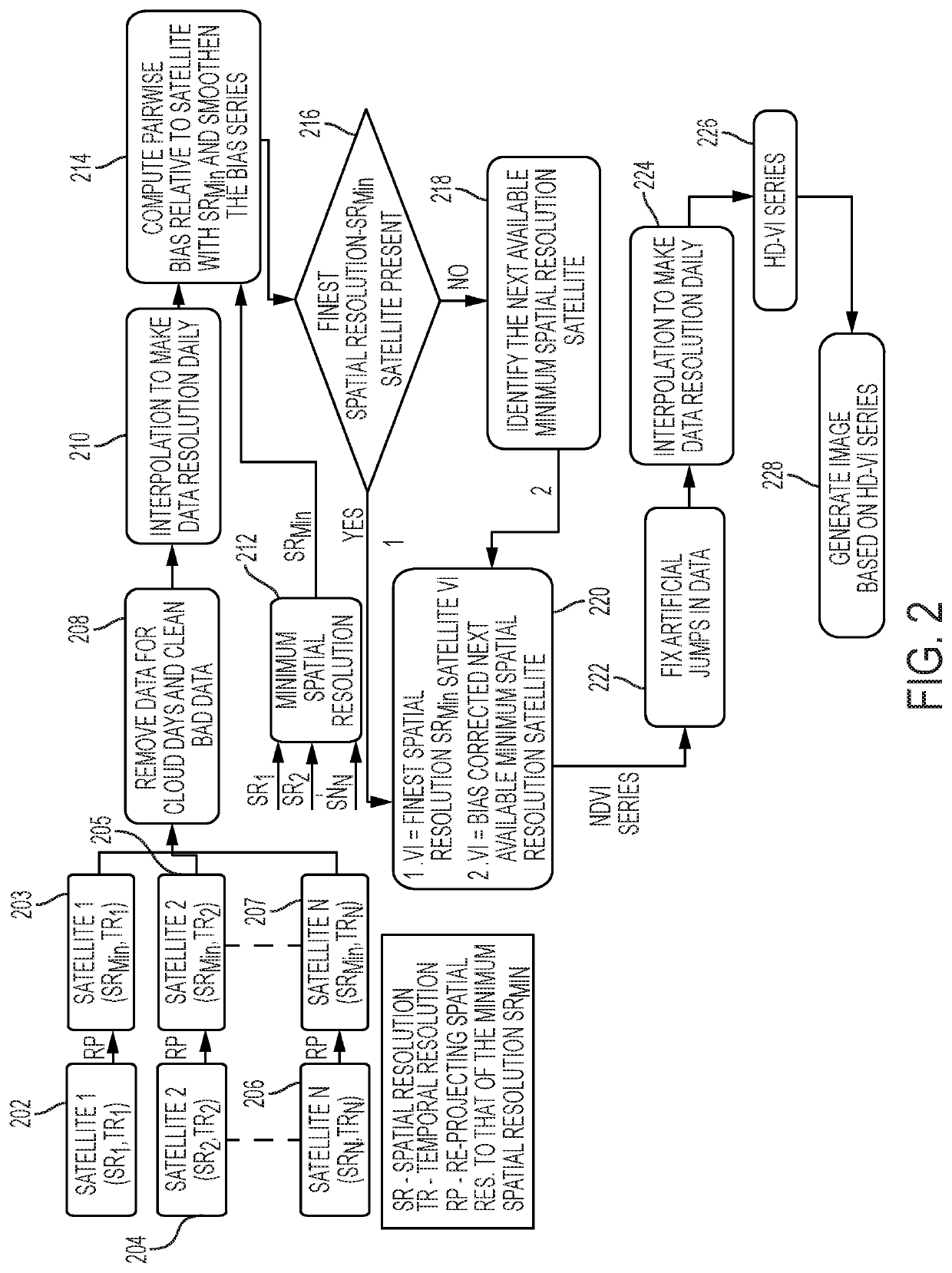
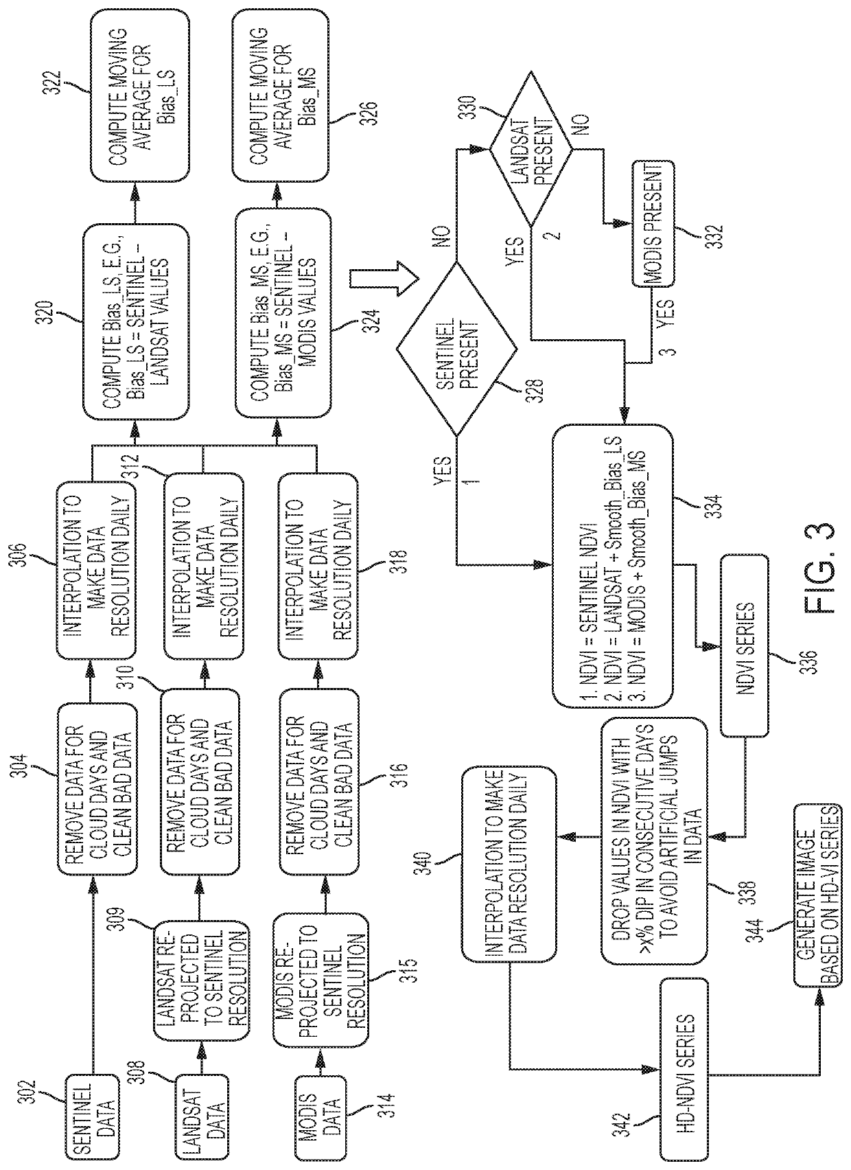
[0015]A system, method, computer program product and techniques in some embodiments provide a blending algorithm, which brings together remote sensed data from a plurality of satellites (e.g., aforementioned satellites) and derive high spatial and temporal resolution NDVI termed High Definition Normalized Difference Vegetation Index (HD-NDVI) at the fine spatial resolution of that satellite data, which has the minimum (finest but minimum in value) spatial resolution among the plurality of satellites and the finest (e.g., daily) temporal resolution.

[0016]Briefly, spatial resolution refers to the size of a pixel. For instance, an image with spatial resolution of 10 meters means that one pixel on the image represents an area or region of 10 by 10 meters on the ground, for example, Earth's surface. Temporal resolution refers to the frequency of visits or how often a satellite visits the same area or region (e.g., collect data of that region), for instance, the time between two subsequen...


PUM


Abstract

A virtual satellite system may receive, re-project to a spatial resolution and interpolate to a desired temporal resolution, georeferenced data representing an image of a geographic region from a plurality of different satellites. Bias in the georeferenced data between the plurality of satellites is determined and based on which satellite's image data contains an identified minimum spatial resolution, vegetation index data may be set to one of the satellite's data, which may or may not be adjusted. A target image may be generated based on the set vegetation index data.

Description

BACKGROUND[0001]The present disclosure relates generally to computers, and computer applications, and more particularly to computer-implemented image processing, for example, of satellite generated images.[0002]Satellites can provide images of Earth's surface, which are used in many applications. For instance, the Landsat and MODIS satellites have been providing spectacular imagery of Earth's surface for over 40 years and 20 years respectively. Joining them is another recent initiative by European Space Agency (ESA) of multispectral Sentinel satellites first launched in 2016. These satellites together can provide a variety of vegetation indices, in particular, Normalized Difference Vegetation Index (NDVI) which is adopted to analyze vegetation patterns and crop phenological characteristics to understand and predict expected yield, pest attacks, water deficiency, and others. A challenge, however, in using the data from multiple satellites to derive common integrated insight is that t...

Claims


Application Information

Patent Timeline
Patent Type & Authority Patents(United States)
IPC IPC(8): G06K9/00G06T5/50G06T5/00G06T7/00G06T3/40
CPCG06T5/50G06T3/40G06T5/003G06T5/005G06T7/0016G06T2207/10036G06T2207/10048G06T2207/20221G06T2207/30188G06T2207/10032
Inventor GOYAL, AANCHALGURUPRASAD, RANJINI B.
Owner INT BUSINESS MASCH CORP
Why Eureka
Try Eureka