Method and system for generating map information for emergency surfaces

a technology for emergency surfaces and maps, applied in navigation instruments, instruments, transportation and packaging, etc., can solve the problems of insufficient accuracy and up-to-dateness of current digital maps, and the inability of sensor systems to register these locations in real time with sufficient accuracy

Active Publication Date: 2021-11-16
CONTINENTAL AUTOMOTIVE GMBH
View PDF24 Cites 3 Cited by
  • Summary
  • Abstract
  • Description
  • Claims
  • Application Information

AI Technical Summary

Benefits of technology

[0024]However, this aspect also allows a surface outside the immediate road area to be categorized as suitable when this cannot be effected reliably by means of a single registration. By way of example, thick vegetation on a surface with longer grasses or cereal can lead to a surface being rated as unsuitable. However, recurring registration over an entire year allows the same surface to be registered again at a time at which there is no or only low vegetation, e.g. owing to mowing that has since taken place, and the actual top of the surface is detectable for a categorization. Seasonally dependent vegetation that does not prevent the surface from being driven on in an emergency can therefore be taken into consideration for the categorization. Naturally, this can also be taken into consideration for the prioritization if multiple surfaces outside the immediate road area are selectable for an imminent minimal risk maneuver. As such, by way of example, it is possible to avoid damage to surfaces used agriculturally if another suitable surface nearby can be reached and is equally well suited. The more data records collected for different seasons for a surface outside the immediate road area, if need be even over several years, the better a suitability of the surface at a particular time can be ascertained.

Problems solved by technology

The currently available digital maps do not map such locations with sufficient accuracy and up-to-dateness that they can be used for the matter of highly automated or autonomous driving.
Currently available sensor systems cannot register these locations with sufficient accuracy in real time and take them as a basis for a driving maneuver.

Method used


Image

  • Method and system for generating map information for emergency surfaces
  • Method and system for generating map information for emergency surfaces
  • Method and system for generating map information for emergency surfaces

Examples


Embodiment Construction

Description of the Exemplary Embodiments

[0037]In the figures of the drawing, identical or similar elements are denoted by the same reference signs.

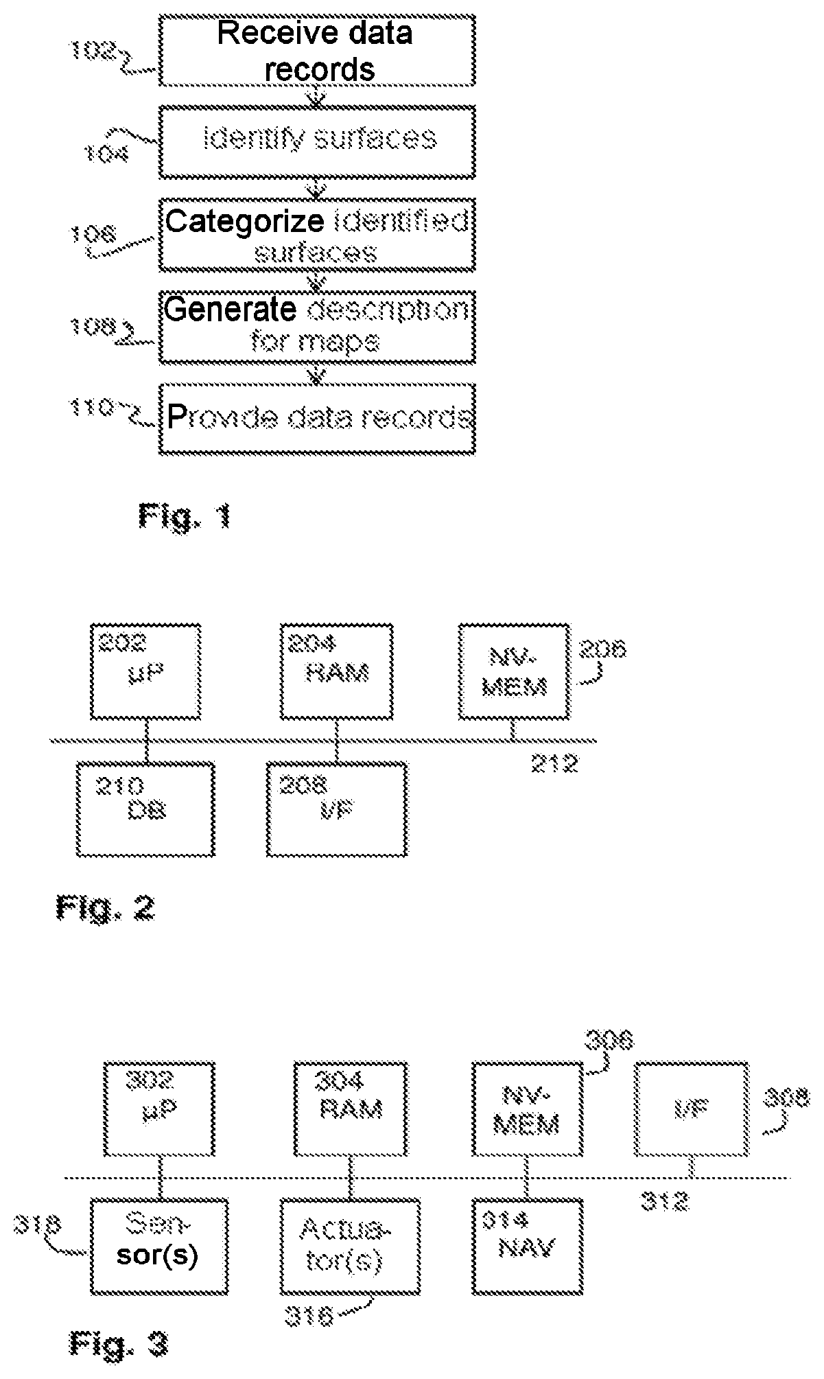
[0038]FIG. 1 shows an exemplary simplified flowchart for an aspect of the method performed by the system. The flowchart can in this instance also be regarded as a depiction of functional modules, each module performing applicable parts of the method. In step or module 102, data records are received that comprise information pertaining to properties of surfaces outside the immediate road area. In step or module 104, the information is subjected to an analysis in order to identify surfaces that can be driven on after leaving a road. In step or module 106, a categorization of the identified surfaces is effected, e.g. on the basis of a suitability for particular vehicle types. In step or module 108, a description in one or more formats suitable for digital road maps is generated for the identified and possibly categorized surfaces, said descr...


PUM


Abstract

A system for generating map information for one or more road sections of a digital road map comprises an interface for receiving data records for the one or more road sections. The data records describe properties of surfaces outside the immediate road area. The system further comprises a first module for evaluating the received data records in order to identify first surfaces outside the immediate road area that are able to be driven on by a vehicle after leaving the road and on which the vehicle can be brought to a standstill after leaving the road, a second module for generating a description of the first surfaces in a format suitable for digital road maps, and a third module for retrievably providing the description of the first surfaces in one or more formats suitable for digital road maps.

Description

BACKGROUNDTechnical Field[0001]The present method and system relate to the generation of map information, for example for use in navigation systems, eHorizon systems, driver assistance systems, or generally as a basis for autonomous or highly automated driving.[0002]eHorizon systems integrate digital topographic map data with sensor data, for example from a GPS receiver, for predictively controlling vehicle systems. Future events, e.g. the gradient after the next curve, are used in advance for adapting control of the vehicle. eHorizon systems in this instance interpret map and sensor data and adapt motor and transmission management, for example, automatically.Prior Art[0003]Some systems today for highly automated or autonomous driving use digital road maps or 3D-CAD models of roads, that is to say digital representations of roads containing not only the road profile projected into a surface but also height information and possibly information pertaining to objects above the road sur...

Claims


Application Information

Patent Timeline
Patent Type & Authority Patents(United States)
IPC IPC(8): G06K9/00B60W30/09B60W30/18G01C21/32
CPCG06K9/00798B60W30/09B60W30/18009G01C21/32B60W2552/00B60W2556/50G01C21/3815G01C21/3822G06V20/588
Inventor KRISTENSEN, STEENHAMER, HENNINGGREWE, RALPH
Owner CONTINENTAL AUTOMOTIVE GMBH
Why Eureka
Try Eureka