Method and apparatus for spatiotemporal valuation of real estate

a technology of spatiotemporal valuation and property, applied in the field of methods and equipment for spatiotemporal valuation of real estate, can solve the problem that relative few properties cannot be valued, and achieve the effect of lowering the cost and time necessary, and quick and accurate valuation

Inactive Publication Date: 2006-01-19
CORELOGIC SOLUTIONS
View PDF65 Cites 127 Cited by
  • Summary
  • Abstract
  • Description
  • Claims
  • Application Information

AI Technical Summary

Benefits of technology

[0016] These valuations are stored for immediate access at a later date. Because the valuation of every, or almost every, property in a very large geographic area has already been run and the valuation stored, the user can request a valuation and receive it immediately. This method dramatically improves upon the prior art by lowering the cost and time necessary to perform a quick and accurate valuation. Additionally, the user can be assured that the valuation is relatively up-to-date. In the preferred embodiment, the regular valuations would be performed every month. In this embodiment, the user could be assured of the accuracy of the valuation in that the property had been valued within the last month.
[0017] Over time, the valuation data that is stored will create a series of data stratum layers. Each “layer” of data stratum will be a set of automated valuation model valuations for all, or almost all, of the properties in the geographic area. In the preferred embodiment, each of these data stratum layers will be created using only automated valuation models based on recent sales and appraisals. Alternatively, when the data stratum is updated each additional time, it could also use these sources and an already existing data stratum layer to create an even more accurate picture of the property values for every home in the area.
[0018] These series of data stratums may be used to do more than provide valuations of every property in a geographic area. The series of data stratums is also useful as a tool for analysis of trends, differences, and patterns in valuation in much smaller time-periods and geographic areas than has ever been possible. Furthermore, a data stratum or series of data stratums can be used to find particular areas of highly valued property within an area of low valuation. It can be used to find low-valued property in the midst of more expensive property for potential purchasers hoping to gain through investing in real estate. The data stratum can be used to determine the percent increase or decrease in valuation for various geographic areas. The data stratum can be used to determine the actual increase or decrease in valuation as measured in dollars for various geographic areas. Numerous other applications are available once the data stratum has been collected. Finally, the data stratum can be employed to create maps, tables, graphs, and “movies” across space and time of each of the above mentioned comparisons and trends. These visual representations of sections of this immense data stratum can be quickly scanned for useful information.

Problems solved by technology

Only a relatively few properties cannot be valued due to data difficulties or exceptions in property features or other reasons.

Method used


Image

  • Method and apparatus for spatiotemporal valuation of real estate
  • Method and apparatus for spatiotemporal valuation of real estate
  • Method and apparatus for spatiotemporal valuation of real estate

Examples


Embodiment Construction

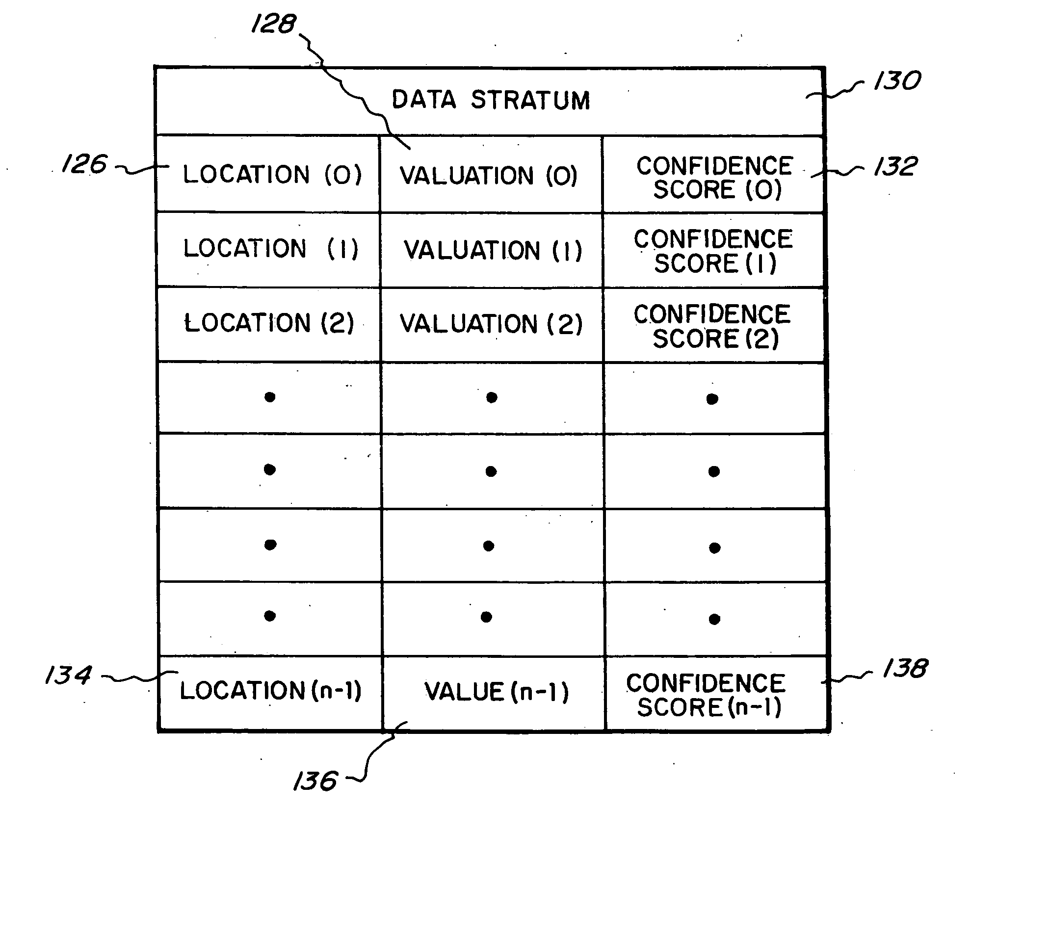
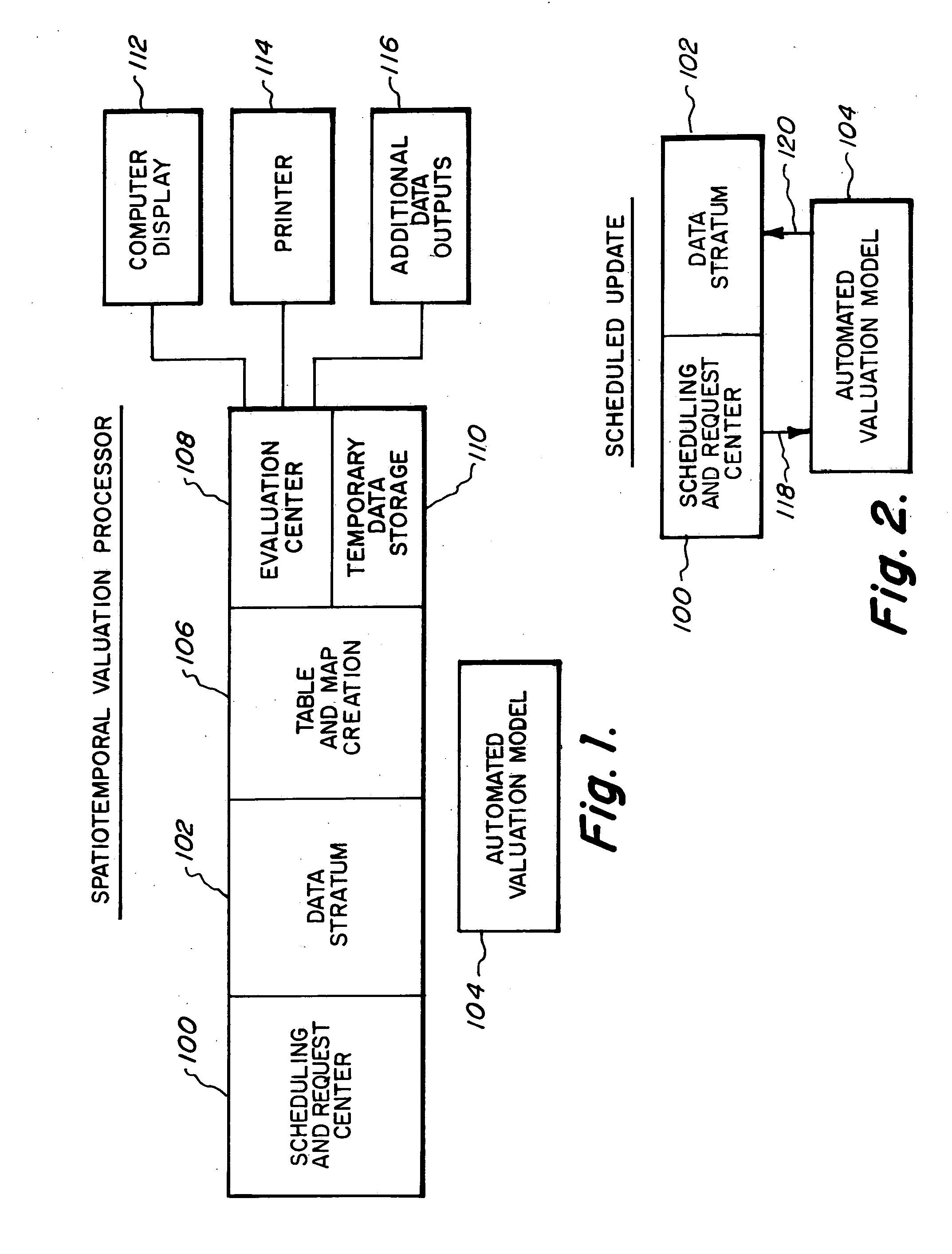
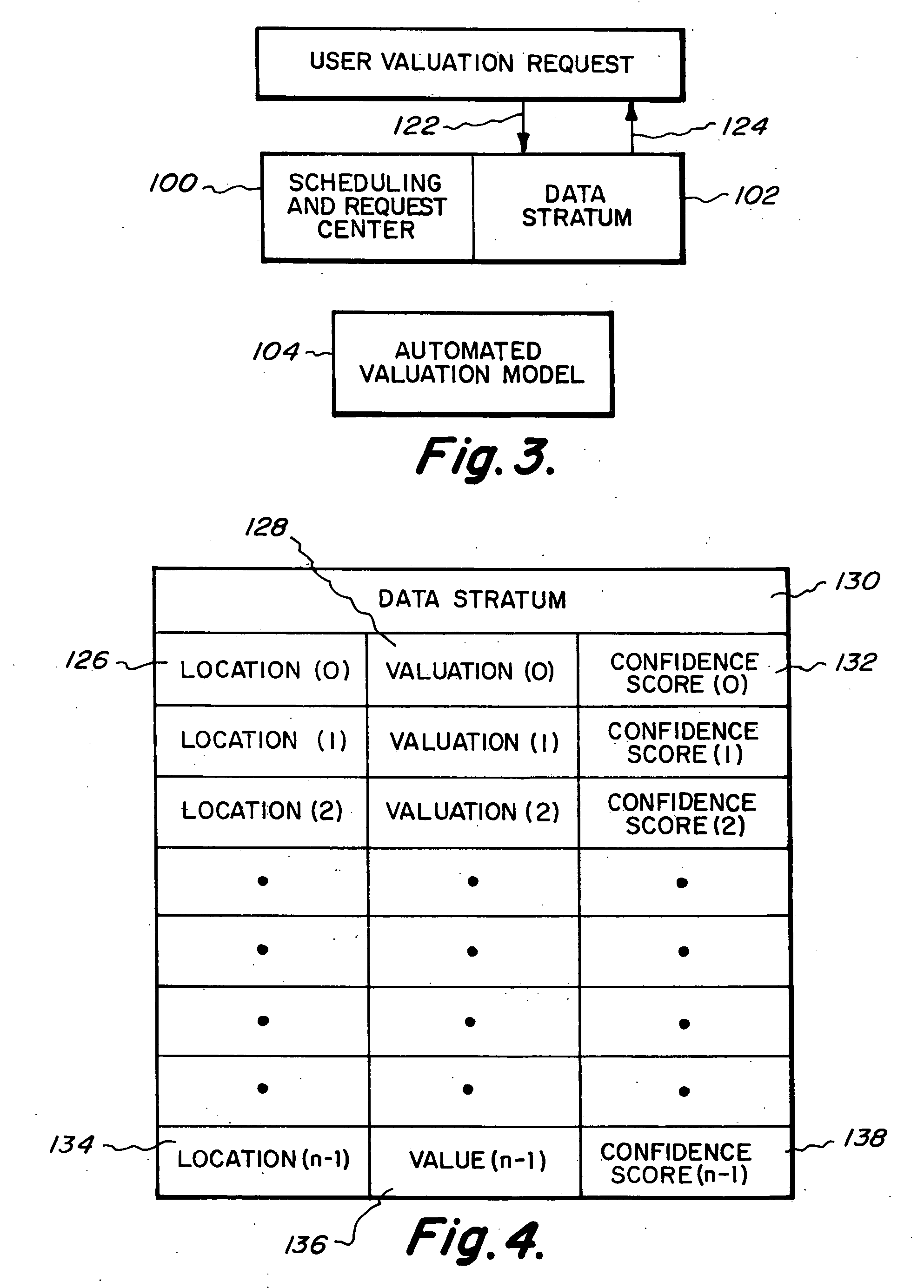
[0042] Referring first to FIG. 1, an overview of the spatiotemporal valuation processor is depicted. The scheduling and request center 100 is responsible for maintaining a schedule of the dates and times on which the data stratum 102 will be updated. This schedule is changeable and could be changed by a user with proper authorization. The data stratum 102 is the element of the spatiotemporal valuation processor that maintains valuations of each and every property in a given geographic area. Additionally, the data stratum 102 maintains previous valuations for each and every property in a given geographic area. Each month or time period's set of valuations thus yields a separate layer of the total data stratum 102. When the user requests that a recent valuation be called up, the data stratum 102 is consulted. The table and map creation 106 is used to create tables from the data within the data stratum 102. When the user requests that a table or map be created, the table and map creati...


PUM


Abstract

A method and apparatus for valuing every property in a predetermined geographic region at regular intervals and storing those valuations for ready access later in a layered data stratum, using customary sources of property valuation data to create a new layers of the data stratum and using the data stored in the one or more layers of the data stratum for the creation of tables, spreadsheets and maps for evaluations of changes and trends in property valuation.

Description

BACKGROUND OF THE INVENTION [0001] 1. Field of the Invention [0002] The present invention relates generally to methods and apparatus for valuing property and, more specifically, to a method and apparatus for valuing all of the real estate in a geographic area using an automated valuation model. [0003] 2. Description of Prior Art [0004] Many real estate lenders and professionals need to receive accurate valuations of a property, such as a single-family residence. A single-family residence could be a detached house, a townhouse, or a condominium. The reasons for these valuations are various. For example, mortgage lenders need to evaluate property with reasonable accuracy in order to ensure that they do not over lend to someone based upon insufficient value in a property. Alternatively, real estate professionals may simply want an accurate valuation of a property in order to know a proper purchasing price for it. On a collective basis, many people would like to know about trends in pri...

Claims


Application Information

Patent Timeline
Patent Type & Authority Applications(United States)
IPC IPC(8): G06Q99/00
CPCG06Q30/0278G06Q30/0205G06Q50/16G06Q30/06
Inventor CAGAN, CHRISTOPHER L.
Owner CORELOGIC SOLUTIONS
Why Eureka
Try Eureka