System and method for generate and update real time navigation waypoint automatically

a real-time navigation and automatic generation technology, applied in the field of navigation, can solve the problems of not updating the waypoints on a timely basis, the satellite image is almost 2 years old, and the inability to provide on-line real-time accurate picture of the existing area and the waypoints, etc., and achieves the effect of easy determination

Active Publication Date: 2007-03-29
GAMBA GRP HLDG LLC
View PDF10 Cites 98 Cited by
  • Summary
  • Abstract
  • Description
  • Claims
  • Application Information

AI Technical Summary

Benefits of technology

[0097] By providing the ability to locate a the user in an area using a Bluetooth enabled device, or a cell phone with our navigation application, the system overcomes the anxiety of “Where will I am” and also facilitates finding a parked car later via the RTP (Return to Parking) feature.
[0172] Waypoints mark a destination, a point along the way to a destination, or a point of reference. Normally, in navigating, a “route” consists of one or more waypoints. To traverse a route, the user navigates to the nearest waypoint, then to the next one in turn until the destination is reached. The system has the ability to compute a great-circle route towards a waypoint, enabling them to find the shortest route even over long distances. The system enabling users to locate a destination on a map and define it as a waypoint. The system is intended for navigation; it can generate a suggested route between two waypoints, based on the cartographic database. The system indicates the user's current location and gives advance notice of an upcoming point.

Problems solved by technology

The most common problem with today's GPS based systems is that the mapping and the waypoints are not updated on a timely basis.
The new service like Google Earth provides satellite images that are almost 2 years old and for sure can't provide on-line real-time accurate picture of the existing area and the waypoints.

Method used


Image

  • System and method for generate and update real time navigation waypoint automatically
  • System and method for generate and update real time navigation waypoint automatically
  • System and method for generate and update real time navigation waypoint automatically

Examples


Embodiment Construction

[0203] In all the figures of the drawings, sub-features and integral parts that correspond to one another bear the same reference symbol.

[0204] Referring now to the drawings in detail and first particularly to FIGS. 1-9 thereof.

[0205] These figures illustrate the method and system to generate and display automatically waypoints along a route for navigation system or application on a cellular phone.

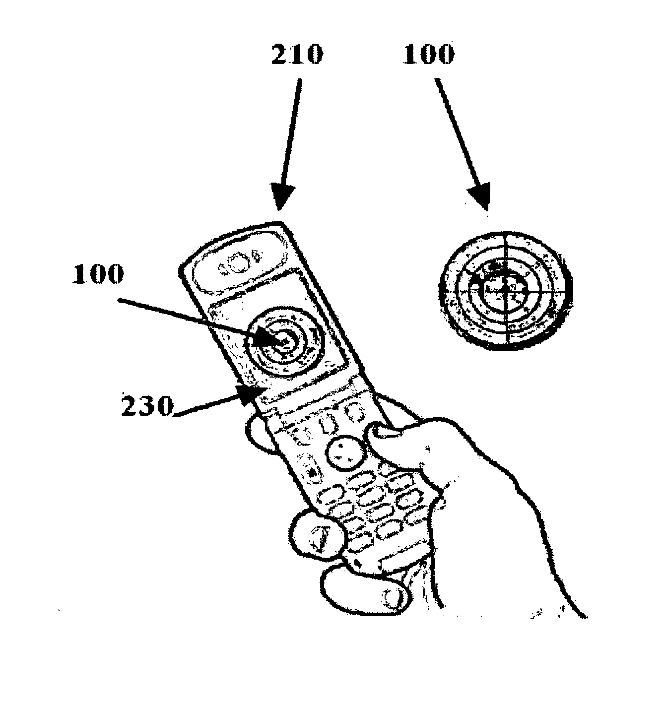
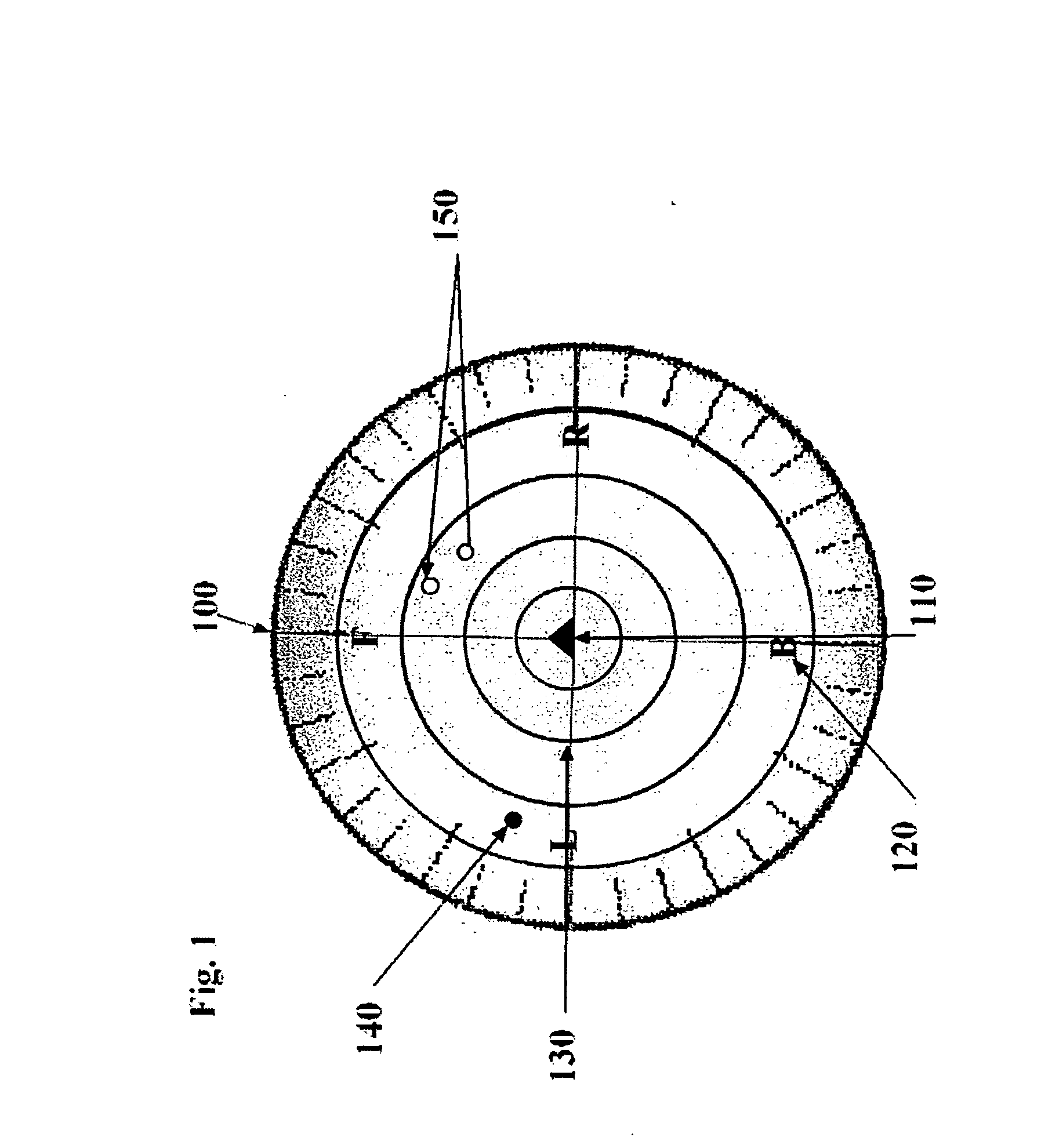
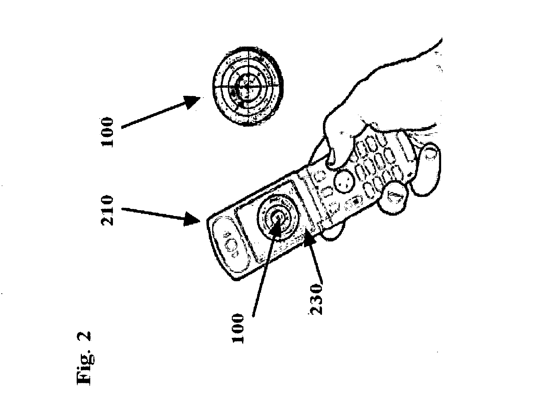
[0206] Referring to FIG. 1, its show The method contain the floating overlay display 100, a real-time floating overlay omni-directional circular display to overcome the limitations of the GPS based systems and the existing mapping systems.

[0207] The “user” will have easy way to figure out the distance and the direction to the waypoint without GPS or any mapping.

[0208] The waypoint will be displayed inside the graphical real-time omni-directional circular display in such way that the “user” will intuitively determine the distance and the direction to the waypoints.

[0209] Each waypoint...


PUM


Abstract

The system method described herein could guide people around urban environments indoor and outdoor, provide accurate update and real time information to the user navigation system and or to his cellular phone, We have focused on the task of generate and update in real time automatically the waypoint along the route, The information will be received directly from the waypoints in the user location and will display on the existing cellular phone as Bluetooth application and interface to existing GPS navigation system.

Description

RELATED APPLICATIONS [0001] This application is a divisional application of U.S. application Ser. No. 11 / 429,864 Filed May 8, 2005 that claim the benefit of the provisional application U.S. Ser. No. 60 / 678,947 filed May 9, 2005.FIELD OF THE INVENTION [0002] This invention is directed generally to the field of navigation and, more particularly, to such method to be used indoors or outdoors navigation for automatic generate and update real time waypoint along the route. BACKGROUND OF THE INVENTION Introduction to Location Based Services: [0003] Location based services are rapidly expanding. Outdoor location technologies are mainly based on GPS technologies. GPS cannot perform properly indoors, and is therefore inadequate. As a result, indoor location systems are appearing on the market. [0004] The need for a system such as ours arises from various market segments and applications. One example in the market is the GPS based systems that use integrated positioning and navigation system...

Claims


Application Information

Patent Timeline
Patent Type & Authority Applications(United States)
IPC IPC(8): G08G1/123H04W4/024H04W4/33
CPCG01C21/206G01S1/68G01S5/02G08B7/066G06Q30/0239G06Q90/20H04W4/04G01S5/0226G01S2205/02H04W4/33H04W4/024
Inventor MENDELSON, EHUD
Owner GAMBA GRP HLDG LLC
Why Eureka
Try Eureka