Markup Language for Interactive Geographic Information System

a geographic information system and markup language technology, applied in the field of mapping systems, can solve the problems of performance degradation of gis that could readily display one, ten, or 100 fire hydrant markers, and performance declin

Active Publication Date: 2008-01-17
GOOGLE LLC
View PDF9 Cites 187 Cited by
  • Summary
  • Abstract
  • Description
  • Claims
  • Application Information

AI Technical Summary

Benefits of technology

[0006] A geographical information system, along with associated methods enables the use of conditional-data in association with data objects to control activation of the data objects in a visual environment, whereby the data objects are loaded and processed in the visual environment. The method includes receiving a request for content of the visual environment to be displayed in a first two dimensional display area of a display device. This method identifies an object in the visual environment and a three dimensional volume associated with the object. The method further generates a second two dimensional area based on the three dimensional volume. The method further activates the data object responsive to a determination that the second two dimensional area is viewable within the first two dimensional area.

Problems solved by technology

Generally, conventional geographic information systems have limited abilities to interactively display large numbers of annotation elements.
For example, a GIS that could readily display one, ten, or one hundred fire hydrant markers may experience performance degradation in loading, processing, or displaying annotation data for one million markers.
This performance decline may be manifested as a noticeable or intolerable pause when loading a large dataset, excessive use of memory and processing resources to operate on a large data set, or slowness of visual updates during rotation, zooming, and otherwise displaying a large dataset.
In some cases, a typical GIS might fail to operate when certain internal algorithmic or implementation limits are exceeded by the size of a very large set of annotations or when the number of annotations creates an algorithmic processing burden that is infeasible for realizable computation.
In this sense, existing GIS are effectively limited in their ability to manage very large sets of annotation data while maintaining interactive performance levels in all aspects of operation.
For example, a GIS may detect that a dataset to be loaded is too large for direct operation at interactive rates and therefore load only a limited number (N) of data elements such as the first N, the last N, a random selection of N elements from the data, or, perhaps, ask the user if the default limit (N) should be raised at the expense of performance and potentially, improper program operation.
Further, the totality of the coastline at the greater level of detail may well contain too much data for the GIS system to load and process at interactive rates, even if any unseen data are discarded through the well-known techniques of view-frustum culling.

Method used


Image

  • Markup Language for Interactive Geographic Information System
  • Markup Language for Interactive Geographic Information System
  • Markup Language for Interactive Geographic Information System

Examples


Embodiment Construction

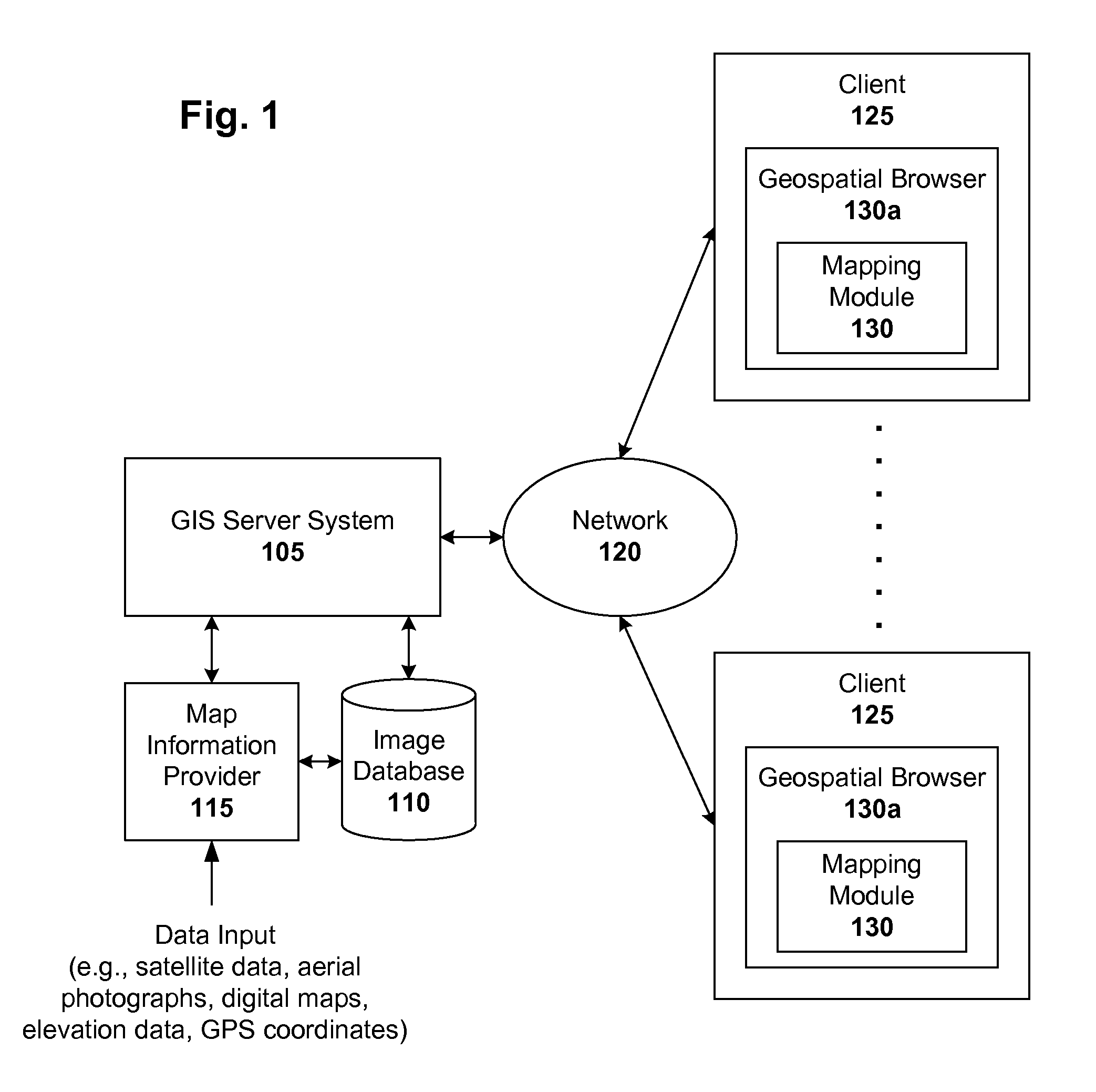
[0018] Geographic information systems (GIS) and techniques are disclosed that provide users with a greater degree of flexibility, utility, and information. The system may be a distributed geographic information system (DGIS) including multiple components that communicate with one another. For purposes of this disclosure, assume that “GIS” includes both GIS and DGIS configurations.

[0019] General Overview

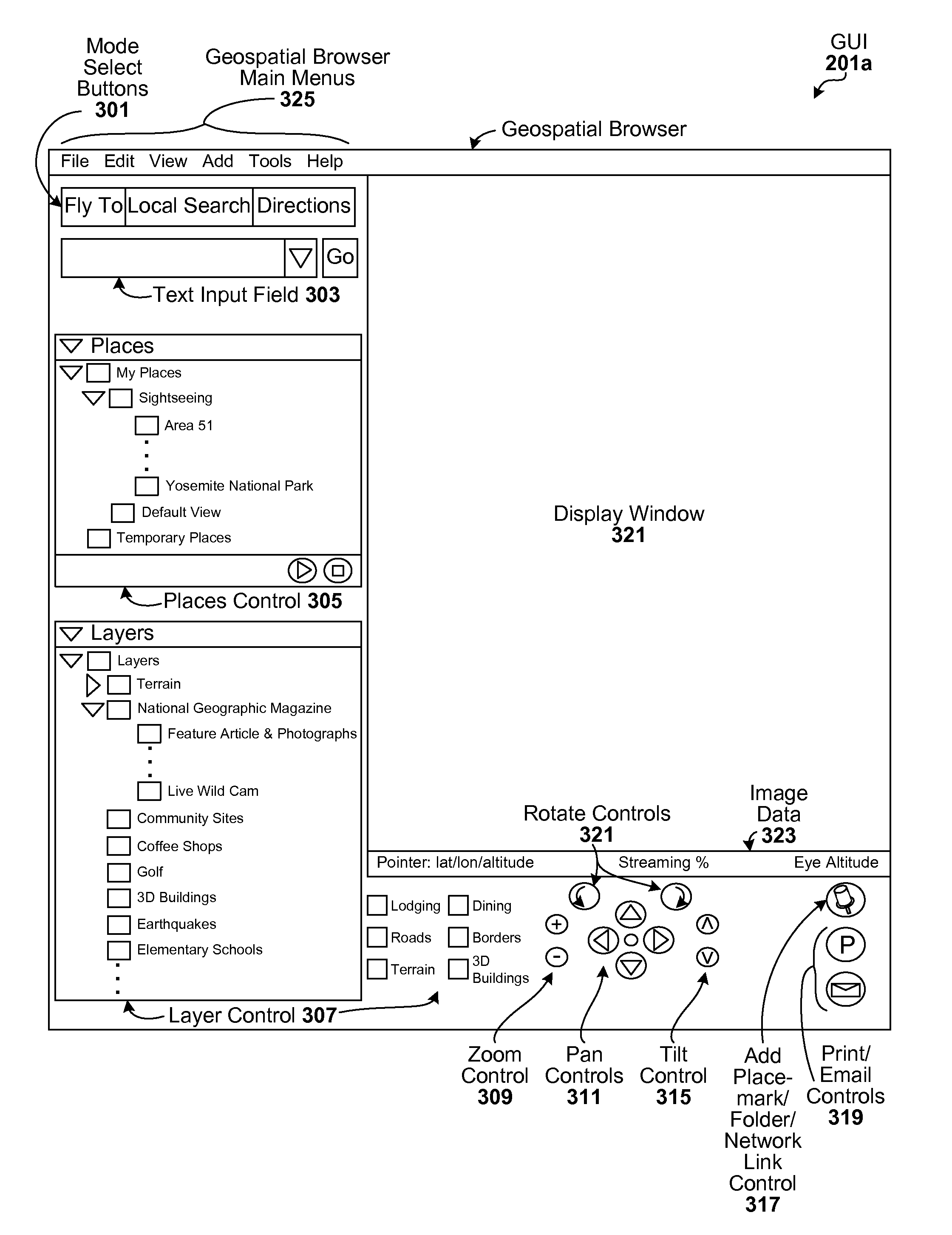
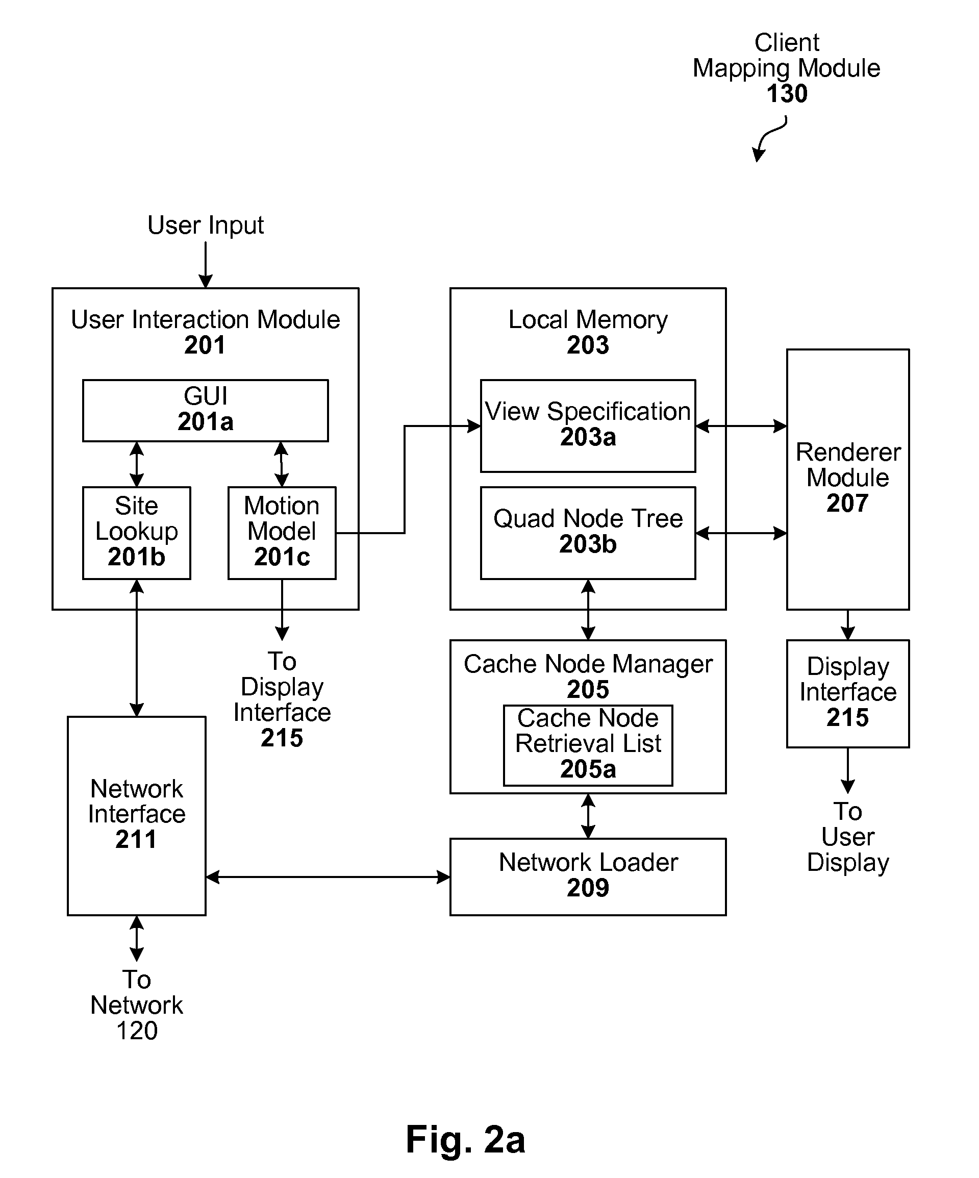
[0020] A GIS configured to carryout the techniques described herein can be implemented, for example, in a client-server architecture, though other configurations will be apparent in light of this disclosure. In this type of embodiment, client-side software operates (in conjunction with server-side software) to cause images of a planet and other geospatial information to a user's computer (or generally, client device) so they can be seen by the user or otherwise processed. In one example case, the client software is implemented using various software objects that are grouped in modul...


PUM


Abstract

Data-driven guarded evaluation of conditional-data associated with data objects is used to control activation and processing of the data objects in an interactive geographic information system. Methods of evaluating conditional-data to control activation of the data objects are disclosed herein. Data-structures to specify conditional data are also disclosed herein.

Description

CROSS REFERENCE TO RELATED APPLICATION [0001] This application claims the benefit under 35 U.S.C 119(e) of U.S. Provisional Application, Ser. No. 60 / 813,059 filed on Jun. 12, 2006 which is incorporated by reference herein.FIELD OF THE INVENTION [0002] The invention relates to mapping systems, and more particularly, to geographic information systems and distributed geographic information systems. BACKGROUND [0003] A geographic information system (GIS) is a system for archiving, retrieving, and manipulating data that has been stored and indexed according to the geographic coordinates of its elements. A geographic information system generally can utilize a variety of data types, such as imagery, maps, and tables. Typical geographic information systems support the display of information such as lines to indicate roadway paths, images of a planetary surface to show natural features, text to indicate city and country names, and terrain elevation data to represent mountains and valleys. O...

Claims


Application Information

Patent Timeline
Patent Type & Authority Applications(United States)
IPC IPC(8): G06K9/46
CPCG06F17/3087G06F17/30241G06F16/29G06F16/9537
Inventor ROHLF, JOHNHAGEMARK, BENTMCCLENDON, BRIANJONES, MICHAEL T.
Owner GOOGLE LLC
Why Eureka
Try Eureka