Method and Apparatus for Monitoring Satellite-Constellation Configuration To Maintain Integrity of Long-Term-Orbit Information In A Remote Receiver

a satellite constellation and long-term orbit technology, applied in surveying and navigation, instruments, navigation instruments, etc., can solve the problems of difficult and sometimes impossible downloading of broadcast ephemera, large range errors of up to 0.8 m, and similar sized errors in the position of gps receivers

Inactive Publication Date: 2008-08-07
AVAGO TECH WIRELESS IP SINGAPORE PTE
View PDF59 Cites 58 Cited by
  • Summary
  • Abstract
  • Description
  • Claims
  • Application Information

AI Technical Summary

Problems solved by technology

Errors in absolute may result in range errors of up to 0.8 m for each millisecond of timing error.
These range errors produce a similarly sized error in the GPS receiver position.
Hence, absolute time accuracy of 10 ms is sufficient for position accuracy of approximately 10 m. Errors in the absolute timing of much more than 10 ms result in large position errors, and so, current and prior implementations have typically required the absolute time to have a minimum accuracy of approximately 10 milliseconds.
When in environments in which the GPS signals have very low signal strengths, downloading the broadcast ephemeris is frequently difficult and sometimes impossible.
Using the assistance data after its validity period expires may prevent acquisition of the satellites and / or cause a significant amount of error in a computed position of the GNSS receiver.
Similarly, the satellite-navigation data, such as stored ephemeris and / or LTO information, may become invalid or be less accurate than broadcast ephemeris despite having an unexpired validity period.
Using such assistance data may prevent acquisition of the satellites and / or cause a significant amount of error in a computed position of the GNSS receiver.

Method used


Image

  • Method and Apparatus for Monitoring Satellite-Constellation Configuration To Maintain Integrity of Long-Term-Orbit Information In A Remote Receiver
  • Method and Apparatus for Monitoring Satellite-Constellation Configuration To Maintain Integrity of Long-Term-Orbit Information In A Remote Receiver
  • Method and Apparatus for Monitoring Satellite-Constellation Configuration To Maintain Integrity of Long-Term-Orbit Information In A Remote Receiver

Examples


Embodiment Construction

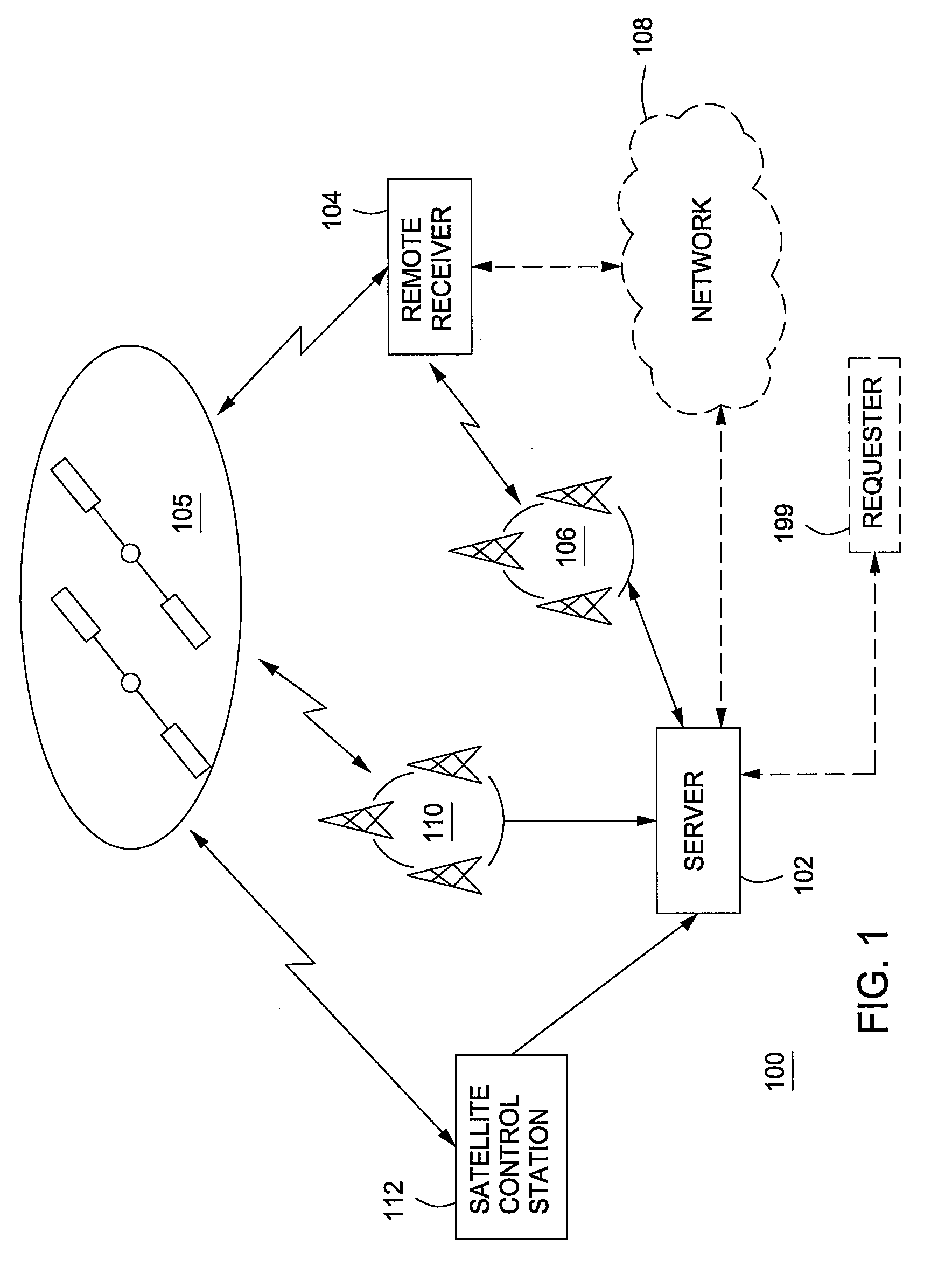
[0041]FIG. 1 is a block diagram depicting an example of a Global Navigation Satellite System (“GNSS”) 100. The GNSS 100 includes a plurality or constellation of satellites for transmitting satellite signals, as represented satellites 105, a GNSS receiver 104 for receiving the satellite signals, and a server 102. The satellites 105, the GNSS receiver 104, the server 102, the GNSS 100 as a whole, and functions, procedures, components and other details provided herein may be tailored for any GNSS, including, for example, the Global Positioning System (“GPS”), GALILEO, GLONASS, SBAS (Space Based Augmentation System), QZSS (Quazi-Zenith Satellite System), LMS (Local Area Augmentation System) or some combination thereof.

[0042]The GNSS receiver 104 may be in communication with the server 102 via a communication link. This communication link may be formed, for example, by communicatively coupling one or more nodes of a network, such as a wireless communication system 106 (e.g., cellular tel...


PUM


Abstract

A method and apparatus for monitoring a configuration of satellites to maintain integrity of LTO information in a GNSS receiver of a GNSS or other positioning system is described. The method may include obtaining broadcast ephemeris transmitted from at least one satellite of a constellation of satellites; comparing the broadcast ephemeris to long-term-orbit information available to a global-navigation-satellite receiver; and causing the global-navigation-satellite receiver to not use the long-term-orbit information when the long-term-orbit information does not correspond to the broadcast ephemeris.

Description

CROSS-REFERENCE TO RELATED APPLICATIONS[0001]This application is a continuation-in-part application of co-pending U.S. patent application Ser. No. 11 / 333,787, filed Jan. 17, 2006 (Attorney Docket GLBL022P2), which is a continuation-in-part application of co-pending U.S. patent application Ser. No. 09 / 993,335, filed Nov. 6, 2001, which is a continuation-in-part of U.S. patent application Ser. No. 09 / 884,874, filed Jun. 19, 2001, now U.S. Pat. No. 6,560,534, which is a continuation-in-part of U.S. patent application Ser. No. 09 / 875,809, filed Jun. 6, 2001, now U.S. Pat. No. 6,542,820.[0002]This application is also a continuation-in-part application of co-pending U.S. patent application Ser. No. 11 / 289,959, filed Nov. 30, 2005, which is a continuation of U.S. patent application Ser. No. 10 / 712,807, filed 13 Nov. 2003, now U.S. Pat. No. 6,992,617.[0003]This application contains subject matter that is related to U.S. patent application Ser. No. 09 / 715,860, filed Nov. 17, 2000, now U.S. P...

Claims


Application Information

Patent Timeline
Patent Type & Authority Applications(United States)
IPC IPC(8): G01S1/00G01S19/04G01S19/07G01S19/11G01S19/27G01S19/48
CPCG01C21/00G01S19/05G01S19/27G01S19/258G01S19/254G01S19/08
Inventor VAN DIGGELEN, FRANKRIBEN, MATTHEW
Owner AVAGO TECH WIRELESS IP SINGAPORE PTE
Why Eureka
Try Eureka