Providing the grid and magnetic azimuths on the electronic maps, and embedding grid magnetic angle, magnetic declination and inclination into the electronic map databases

a technology of electronic maps and magnetic azimuths, which is applied in the direction of navigation, instruments, surveying and navigation, etc., can solve the problem that distance information cannot uniquely determine the destination

Inactive Publication Date: 2008-12-18
HUANG JIANTAO
View PDF4 Cites 5 Cited by
  • Summary
  • Abstract
  • Description
  • Claims
  • Application Information

AI Technical Summary

Problems solved by technology

However, when hiking in the field, sailing or aviating, the road information is not applicable and the distance information cannot uniquely determine the destination.

Method used


Image

  • Providing the grid and magnetic azimuths on the electronic maps, and embedding grid magnetic angle, magnetic declination and inclination into the electronic map databases
  • Providing the grid and magnetic azimuths on the electronic maps, and embedding grid magnetic angle, magnetic declination and inclination into the electronic map databases
  • Providing the grid and magnetic azimuths on the electronic maps, and embedding grid magnetic angle, magnetic declination and inclination into the electronic map databases

Examples


Embodiment Construction

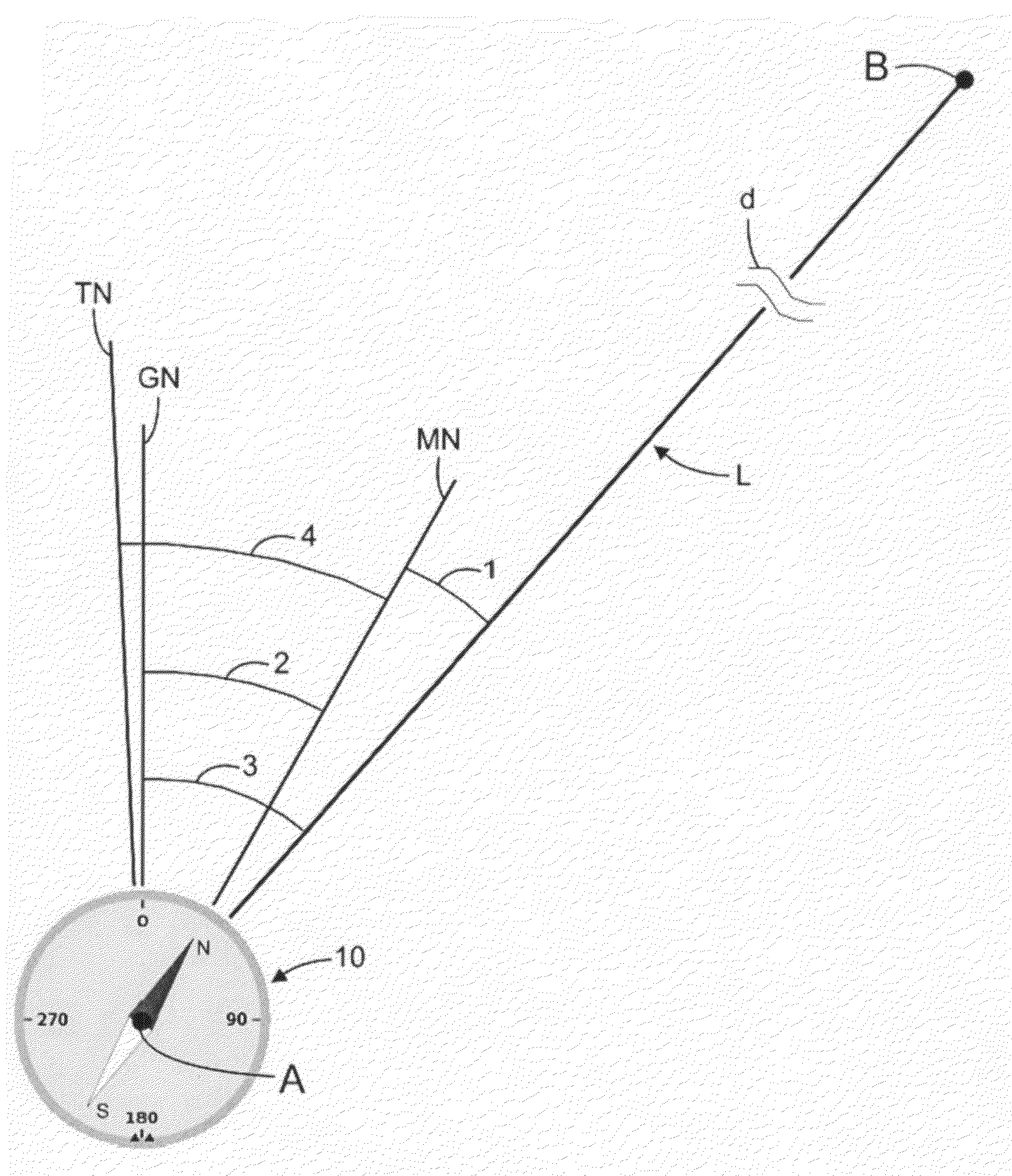
[0049]Providing the desired navigation direction relative to the Magnetic North on the electronic map is very useful for people to navigate on the land (hiking), water surface (sailing) or in the air (piloting). This invention adds the azimuth information to the electronic maps, which makes these maps useful for outdoor activities as well as for road travel. This Interactive Navigation Map provides the Magnetic Azimuth ((1) in FIG. 3) without the user doing any measurement and calculation (it is very awkward to do any measurement on the screen). In order to achieve this, the electronic map needs to know the Grid Magnetic Angle θGM for each geographic location, which can be obtained by multiple ways including but not limited to (in the order of increasing implementation effort):[0050]1. Asking the user to interactively input the Grid Magnetic Angle θGM for the pertinent geographic location.[0051]2. Sending an instant database query to National Geophysical Data Center (NGDC) or other ...


PUM


Abstract

An electronic Interactive Navigation Map was built to provide the Magnetic Azimuths θM of desired moving directions relative to the Magnetic North. The system presents the most useful information for navigation. The system connects a series of waypoints by straight-line segments, and provides one pair of (θM, d) values per segment. Existing electronic maps are designed for road navigation, but lack the key azimuth information for navigation in no-road environment. To compute the θM, the Interactive Navigation Map needs the Grid Magnetic Angle that can be obtained by various methods including: 1. Asking the user to interactively input the information. 2. Sending an instant database query to National Geophysical Data Center or other resources over the Internet. 3. Embedding the Grid Magnetic Angle, Magnetic Declination and Inclination into the electronic map database.

Description

CROSS-REFERENCE TO RELATED APPLICATIONS[0001]This is the first filing of this “Interactive Navigation Map” application. There is no related pending or granted application filed previously.STATEMENT REGARDING FEDERALLY SPONSORED RESEARCH OR DEVELOPMENT[0002]The inventor grants the rights to inventions made under federally sponsored research and development.BACKGROUND OF THE INVENTION[0003]Previous electronic maps focus on providing driving instruction in a world connected by roads. Therefore road and distance information are provided. However, when hiking in the field, sailing or aviating, the road information is not applicable and the distance information cannot uniquely determine the destination. For instance, the previous “Kloba Filter” (http: / / www.klobad.com / maps / ) accepts interactive input of a series of waypoints, connects those points into straight-line segments, and adds up the distance of all segments. By assuming the users select the path along the streets, the Kloba Filter...

Claims


Application Information

Patent Timeline
Patent Type & Authority Applications(United States)
IPC IPC(8): G01C21/32
CPCG01C21/32G01C21/3807G01C21/3881
Inventor HUANG, JIANTAO
Owner HUANG JIANTAO
Why Eureka
Try Eureka