Adding positional information for surfaces in a geological formation after transforming to a gapped representation

a geological formation and position information technology, applied in the field of interpretive earth modeling, can solve the problems of limited surface sample points that can be collected in a geological formation, high drilling costs, and insufficient surface sampling density, and achieve the effect of enhancing the quality of surface modeling

Active Publication Date: 2009-03-05
LANDMARK GRAPHICS
View PDF9 Cites 1 Cited by
  • Summary
  • Abstract
  • Description
  • Claims
  • Application Information

AI Technical Summary

Benefits of technology

[0010]In one set of embodiments, a computer-implemented method for enhancing the quality of modeling of surfaces in a geological formation may involve the following operations. First, a computer may receive user input selecting a subset S of wells from a collection of wells. Second, the computer may display a cross section of the geological formation through the wells of the subset S. The displayed cross section includes well picks for the wells of the subset S. Third, the computer may open a gap in an unconformity of the displayed cross section. The gap is opened at one or more wells of the subset S that intersect the unconformity. The gap represents non-deposition and / or material that is missing from the geological formation due to erosion. Fourth, the computer may receive user input specifying positions of tops within the gap. Fifth, the computer may close the gap in response to a user command. The action of closing the gap includes calculating positions of restored tops based on the positions of the tops specified within the gap. The positions of the restored tops are usable to model one or more surfaces in the geological formation. The computer may store the positions of the restored tops in a memory medium.

Problems solved by technology

Because the drilling of wells is expensive, the number of surface sample points that can be gathered in a geological formation is limited.
Thus, some of the surfaces may be not be sampled sufficiently densely to allow an accurate estimation of the surfaces.
The existing methods for handling the under-constrained surface problem (using isochore or isopach maps) are cumbersome.
If such a surface does not exist there is no simple way to model the less well-constrained surfaces.
Second, the computer may display a cross section of the geological formation through the wells of the subset S. The displayed cross section includes well picks for the wells of the subset S. Third, the computer may open a gap in an unconformity of the displayed cross section.
Fifth, the computer may close the gap in response to a user command.

Method used


Image

  • Adding positional information for surfaces in a geological formation after transforming to a gapped representation
  • Adding positional information for surfaces in a geological formation after transforming to a gapped representation
  • Adding positional information for surfaces in a geological formation after transforming to a gapped representation

Examples


Embodiment Construction

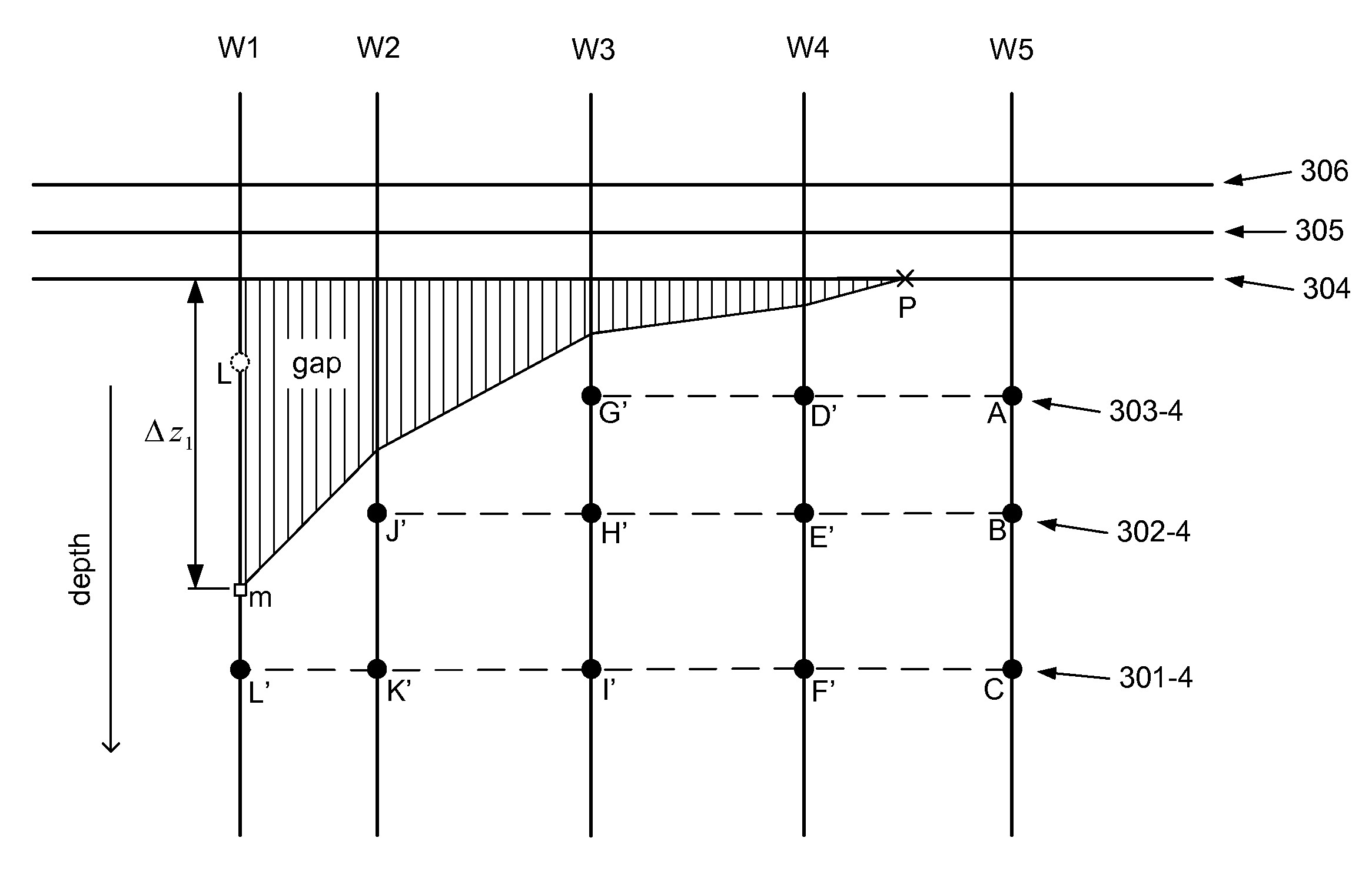
[0033]In one set of embodiments, a computer-implemented method for operating on a geological data set, that includes well picks for a collection C of wells in a geological formation, may involve the following operations, as illustrated in FIG. 2.

[0034]At step 110, a computer may receive user input selecting a subset S of the wells from the collection C. To facilitate selection of the subset S, the computer may display a window 210 containing a two-dimensional plot of well positions in a field, as illustrated in FIG. 3A. (The window illustrates well positions as seen looking down on the field.) The user may select wells by clicking on (or otherwise identifying) the positions of the wells in the window. In some embodiments, the user input specifies an ordered sequence of wells. While the example of FIG. 3A shows a sequence of five wells (W1 through W5) that have been selected by a user, any number of wells may be selected.

[0035]At step 115, the computer may display a window showing a ...


PUM


Abstract

A system, method and memory medium for injecting positional information into a geological data set for improved modeling of surfaces in a geological formation. The method involves: (1) displaying a cross section of the formation through a selected subset of wells, where the displayed cross section includes well picks for the selected wells; (2) opening a gap in an unconformity of the displayed cross section, where the gap is opened at one or more wells that intersect the unconformity, where the gap represents non-deposition and/or material that is missing from the formation due to erosion; (3) receiving user input specifying positions of tops within the gap; and (4) closing the gap, where closing the gap includes calculating positions of restored tops based on the positions of the tops specified within the gap, where the positions of the restored tops are usable to model one or more surfaces in the formation.

Description

RELATED APPLICATION DATA[0001]This application claims the benefit of U.S. Provisional Application No. 60 / 969,860, filed on Sep. 4, 2007, entitled “Injecting Points onto Surfaces of a Geological Formation for Improved Representation of those Surfaces by Surface Models”, invented by William C. Ross. This provisional application is hereby incorporated by reference in its entirety.FIELD OF THE INVENTION[0002]The present invention generally relates to the field of interpretive earth modeling, and more particularly, to a system, method and memory medium for the injection of additional points onto surfaces of a geological formation.DESCRIPTION OF THE RELATED ART[0003]A geological formation includes a number of layers. The boundaries between the layers are referred to herein as surfaces. Wells may be drilled into the geological formation in order to gather information about the layers and the surfaces between them. In particular, samples of position on the surfaces may be determined. Becaus...

Claims


Application Information

Patent Timeline
Patent Type & Authority Applications(United States)
IPC IPC(8): G06G7/48
CPCG01V99/00
Inventor ROSS, WILLIAM C.
Owner LANDMARK GRAPHICS
Why Eureka
Try Eureka