Terrain overlay for route planner

a route planner and overlay technology, applied in the field of route generation, can solve the problems of not being able to account for terrain or topology information, and being unable to generate computer-generated maps and routed by point-to-point mapping systems

Inactive Publication Date: 2009-10-01
AGERE SYST INC
View PDF15 Cites 15 Cited by
  • Summary
  • Abstract
  • Description
  • Claims
  • Application Information

AI Technical Summary

Problems solved by technology

In these cases, computer-generated maps and routed by point-to-point mapping systems are not well-suited for turn-by-turn directions in closed loops, since these point-to-point mapping systems generally are optimized to provide the shortest route between two points.
Unfortunately, such closed loop mapping systems, while providing routes that account for road length and size, do not account for terrain or topology information.

Method used


Image

  • Terrain overlay for route planner
  • Terrain overlay for route planner
  • Terrain overlay for route planner

Examples


Embodiment Construction

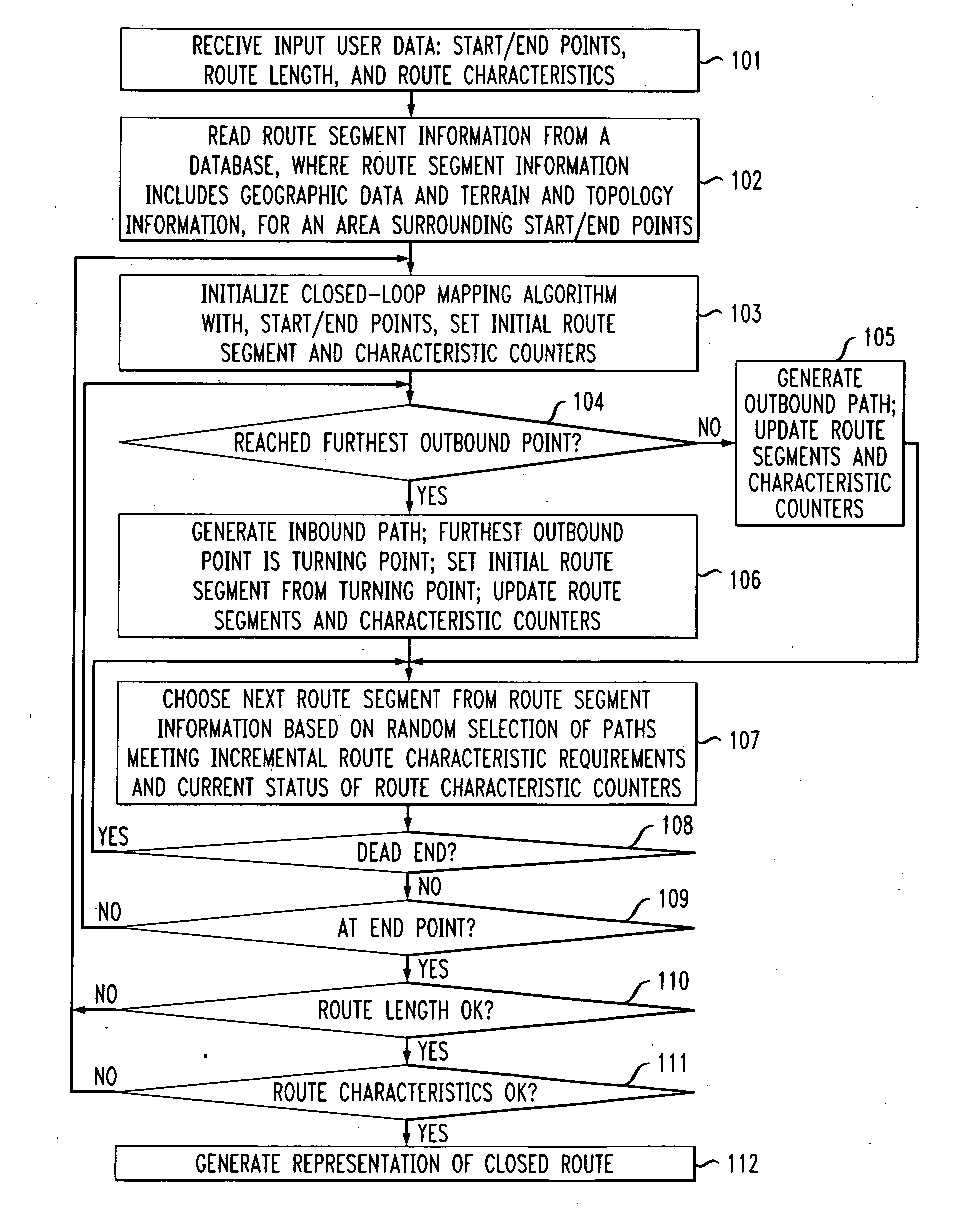
[0017]In accordance with exemplary embodiments of the present invention, a closed-loop mapping system employs terrain and topology information when generating a closed route given input desired route characteristics. Terrain and topology information collectively identify, for example, whether the road is 1) flat or inclined; 2) paved, concrete, crushed stone, or dirt; 3) in open or shaded areas, and 4) within certain area types. While the exemplary embodiments described herein refer to a closed-loop mapping system having the same geographic start and end point, the present invention is not so limited, and might be extended to other mapping systems that employ methods that do not necessarily start and end at the same point, but rather at predefined geographic start and end points that may be defined by a user's input data to the mapping system algorithm.

[0018]FIG. 1 shows an exemplary flowchart for a method employed by a closed loop mapping system in accordance with an exemplary embo...


PUM


Abstract

In described embodiments, closed-loop mapping employs terrain and topology information when generating a closed-loop route given input route characteristics. Terrain and topology information collectively identify, for example, whether the road is 1) flat or inclined; 2) paved, concrete, crushed stone, or dirt; 3) in open or shaded areas, and 4) within certain area types. The location of the start and end points (e.g., a geographic location or position), the length of the desired route, and route characteristics are received as input to generate the closed-loop route. Route characteristics might include, for example, i) particular inclines / declines to modify the cardiovascular exercise from traversing the output closed route, ii) preferred types of terrain the output closed route includes, such as pavement or dirt paths, and iii) particular zones or areas to be included or avoided in the desired route.

Description

BACKGROUND OF THE INVENTION[0001]1. Field of the Invention[0002]The present invention relates to route generation, and, in particular, to incorporation of terrain factors in route planning systems.[0003]2. Description of the Related Art[0004]Computer generated maps are known and in relatively wide use. For example, many GPS (Global Positioning System) products employ computer-generated maps that are used in conjunction with user location information determined through the GPS system to plan trip routes and directions for user travel. Web-based map sites, such as Google, MapQuest, and Yahoo, also offer customized, point-to-point directions from any starting address to any destination address (termed herein “point-to-point mapping systems”).[0005]For activities such as hiking, bicycling, and running, a user's desired route might have a desired length and might start and end in the same location. In these cases, computer-generated maps and routed by point-to-point mapping systems are n...

Claims


Application Information

Patent Timeline
Patent Type & Authority Applications(United States)
IPC IPC(8): G01C21/34G01S5/00
CPCG01C21/3461
Inventor GREWE, ANTHONY J.
Owner AGERE SYST INC
Why Eureka
Try Eureka