Method of deriving digital terrain models from digital surface models

Active Publication Date: 2009-12-10
TELECOM ITALIA SPA
View PDF2 Cites 18 Cited by
  • Summary
  • Abstract
  • Description
  • Claims
  • Application Information

AI Technical Summary

Benefits of technology

[0013]The Applicant has tackled the problem of providing a method for deriving DTMs from DSMs automatically, without the use of additional information sources and even in presence of DSMs that are affected by significant noise, i.e. DSMs possibly acquired using relatively simple and inexpensive techniques like the photogrammetry, and not necessitating sophisticated acquisition techniques like the LIDAR. In fact, compared to acquisition techniques like the conventional photogrammetry, the acquisition of high-quality DSMs exp

Problems solved by technology

In fact, compared to acquisition techniques like the conventional photogrammetry, the acquisition of high-quality DSMs exploiting LIDAR techniques such as the known ALS (Airborne Laser Scanning) are very expensive, because the acquisition requires flights at a lower height over the ground surface and at a lower speed; moreo

Method used


Image

  • Method of deriving digital terrain models from digital surface models
  • Method of deriving digital terrain models from digital surface models
  • Method of deriving digital terrain models from digital surface models

Examples


Example

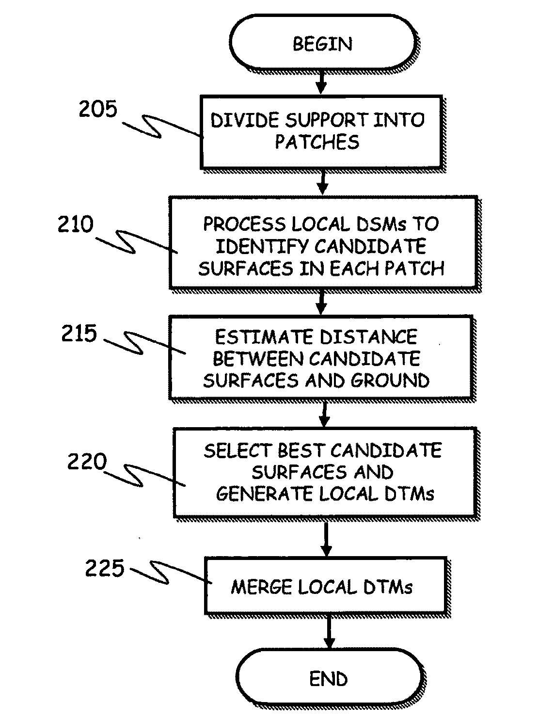
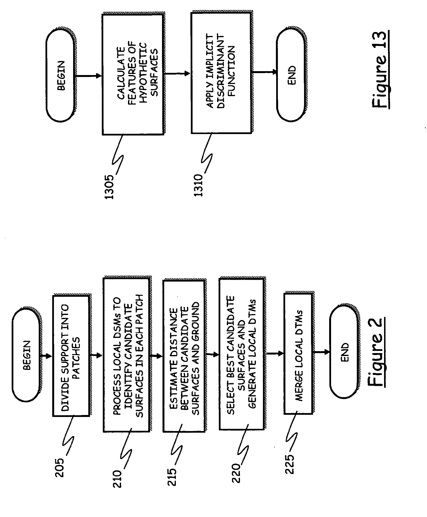
[0074]A DSM and a DTM are digital models of the Earth's surface that contain data describing the heights in terms of a function h on a set G of coordinates of a coordinate system in a two-dimensional space. These models are mathematically expressed as:

H={h(x,y)εR:(x,y)εG⊂R2}  (1)

where (x,y) are the two coordinates of the coordinate system, representing for example the latitude and the longitude, R is the field of real numbers, and h denotes the height of the generic point of coordinates (x,y); the height h may be referred to a surface passing for the average level of the sea (this corresponds to considering the Earth as a geoid); the set G of coordinate values is called “the support” of the digital Earth's surface model.

[0075]According to an embodiment of the present invention, the two coordinates (x,y) can take discrete values, i.e. the coordinate system consists of a discrete grid. The support G may coincide with the discrete grid, or, in case of Earth's surface models defined on ...


PUM


Abstract

A method of deriving a digital terrain model from a digital surface model of an area of interest includes: dividing the area of interest into a plurality of area portions or patches; calculating, from the digital surface model, a set of candidate surfaces adapted to represent a ground surface in each area portion; if such set includes at least two candidate surfaces, estimating a distance from the ground surface of each candidate surface by using a function of a set of geometrical features related to the considered candidate surface, such function being derived from a known relation between a digital surface model and the height of the ground surface in a reference area; selecting, as a representation of the ground surface in each area portion, the candidate surface having the smallest distance from the ground surface, so as to obtain local digital terrain models; and merging the different digital terrain models.

Description

BACKGROUND OF THE INVENTION[0001]1. Field of the Invention[0002]The present invention generally relates to methods for obtaining geometrical models of the Earth surface, particularly, but not limitatively, for use in the planning of the coverage of radio communications network.[0003]2. Description of the Related Art[0004]Geometrical models of the Earth surface play an important role in fields like the radio communications network coverage planning, e.g. in mobile telecommunications systems like the UMTS (Universal Mobile Telecommunications System), or in broadcasting systems like the DVB-T (Digital Video Broadcasting-Terrestrial) and the DVB-H (Digital Video Broadcasting-Handheld), the latter being a digital video broadcasting over a mobile telecommunications network, the WiMAX.[0005]Mainly, two classes of geometrical models of the Earth surface are known: the class of Digital Surface Models (DSMs), and that of Digital Terrain Models (DTMs).[0006]A DSM provides a representation of t...

Claims


Application Information

Patent Timeline
IPC IPC(8): G06K9/00
CPCG06T17/05
Inventor FRANCINI, GIANLUCALEPSOY, SKJALG
Owner TELECOM ITALIA SPA
Why Eureka
Try Eureka