
Method for providing satellite orbit ephemeris, server, and positioning system

a satellite orbit and server technology, applied in surveying and navigation, instruments, navigation instruments, etc., can solve the problems of waste of memory, data not used by the positioning device becomes useless, and the positioning device does not necessarily use all the data in practical measurement, so as to reduce the amount of data

Active Publication Date: 2009-12-24
SEIKO EPSON CORP
View PDF7 Cites 28 Cited by
  • Summary
  • Abstract
  • Description
  • Claims
  • Application Information

AI Technical Summary

Benefits of technology

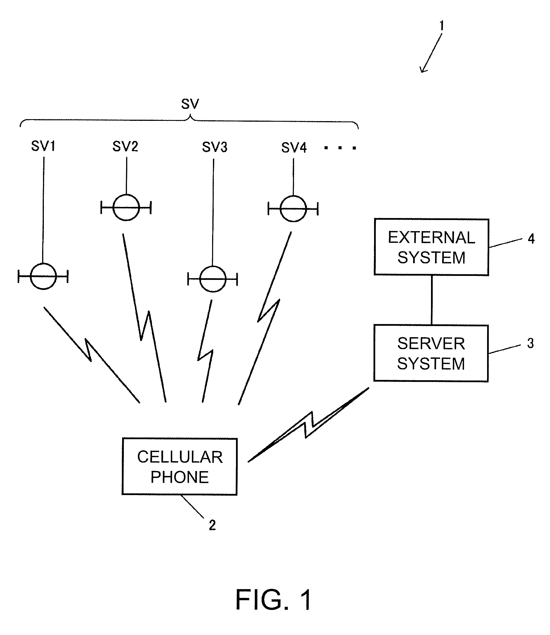
The invention provides a method to reduce the amount of data on a long-term predicted ephemeris provided for a positioning device. This is achieved by determining positioning satellites in view of a predetermined reference position and providing a satellite orbit ephemeris of the positioning satellite in view of the reference position. The positioning device measures a position based on the satellite orbit ephemeris and the data size of the predicted satellite orbit ephemeris is effectively reduced. The invention also includes a server that provides the satellite orbit ephemeris to the positioning device and a positioning system that includes the positioning device and the server. The technical effect of the invention is to improve the efficiency of positioning devices and reduce the data size of the predicted satellite orbit ephemeris.

Problems solved by technology

However, the positioning device does not necessarily use all of the data in practical measurement.
In this case, the data not used by the positioning device become useless and waste memory.

Method used


Image

  • Method for providing satellite orbit ephemeris, server, and positioning system
  • Method for providing satellite orbit ephemeris, server, and positioning system
  • Method for providing satellite orbit ephemeris, server, and positioning system

Examples


modified examples

[0128]Modified examples will now be explained in view of the similarity between the unmodified embodiment and the modified example, the parts of the modified example that are identical to the parts of the unmodified embodiment will be given the same reference numerals as the parts of the unmodified embodiment. Moreover, the descriptions of the parts and steps of the modified examples that are identical to the parts and steps of the unmodified embodiment may be omitted for the sake of brevity.


PUM


Abstract

A method for providing satellite orbit ephemeris includes: determining a positioning satellite in view of a reference position; and providing to a positioning device a satellite orbit ephemeris of the positioning satellite in view of the reference position, the satellite orbit ephemeris being valid for at least one day.

Description

[0001]This application claims priority to Japanese Patent Application No. 2008-160818 filed on Jun. 19, 2008. The entire disclosure of Japanese Patent Application No. 2008-160818 is hereby incorporated herein by reference.BACKGROUND[0002]1. Technical Field[0003]The present invention relates to a method for providing a satellite orbit ephemeris, a server, and a positioning system.[0004]2. Related Art[0005]A GPS (global positioning system) is widely known as a positioning system using positioning signals, and used in a positioning device included in a cellular phone, a car navigation system, and the like. The GPS measures positions using a positioning calculation that calculates four parameters of three-dimensional coordinates indicating the GPS and clock error based on information such as positions of plural GPS satellites and pseudo distances between the respective GPS satellites and the GPS.[0006]According to the position measurement by the GPS, satellite information such as positi...

Claims


Application Information

Patent Timeline
Patent Type & Authority Applications(United States)
IPC IPC(8): G01S1/00G01C21/00G01S19/27
CPCG01S19/05G01S19/33G01S19/258
Inventor TOMITA, KYOICHI
Owner SEIKO EPSON CORP
Learn More