Method for dynamic creation of a geofence in a wireless system

a wireless system and dynamic creation technology, applied in the direction of vehicle position/course/altitude control, process and machine control, instruments, etc., can solve the problem of difficulty in determining if a moving target has entered and/or left a geographic area surrounding another moving targ

Active Publication Date: 2010-01-21
QUALCOMM INC
View PDF13 Cites 165 Cited by
  • Summary
  • Abstract
  • Description
  • Claims
  • Application Information

AI Technical Summary

Benefits of technology

[0004]According to one aspect, a user activates a GeoFence device to automatically define a surrounding GeoFence area at his present location, eliminating the need for the user look up his present location and program a GeoFence area.

Problems solved by technology

It is also difficult to determine if a moving target has entered and / or exited a geographic area surrounding another moving target.

Method used


Image

  • Method for dynamic creation of a geofence in a wireless system
  • Method for dynamic creation of a geofence in a wireless system
  • Method for dynamic creation of a geofence in a wireless system

Examples


Embodiment Construction

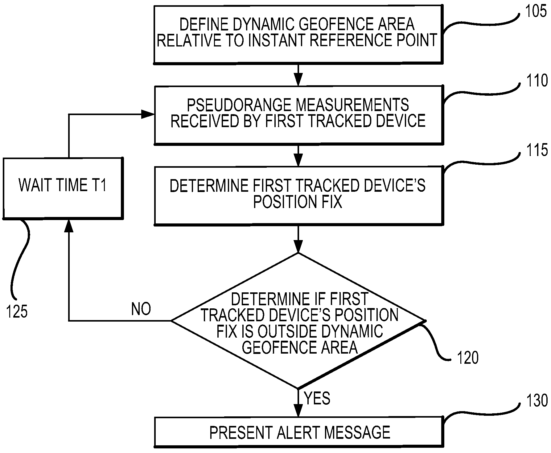
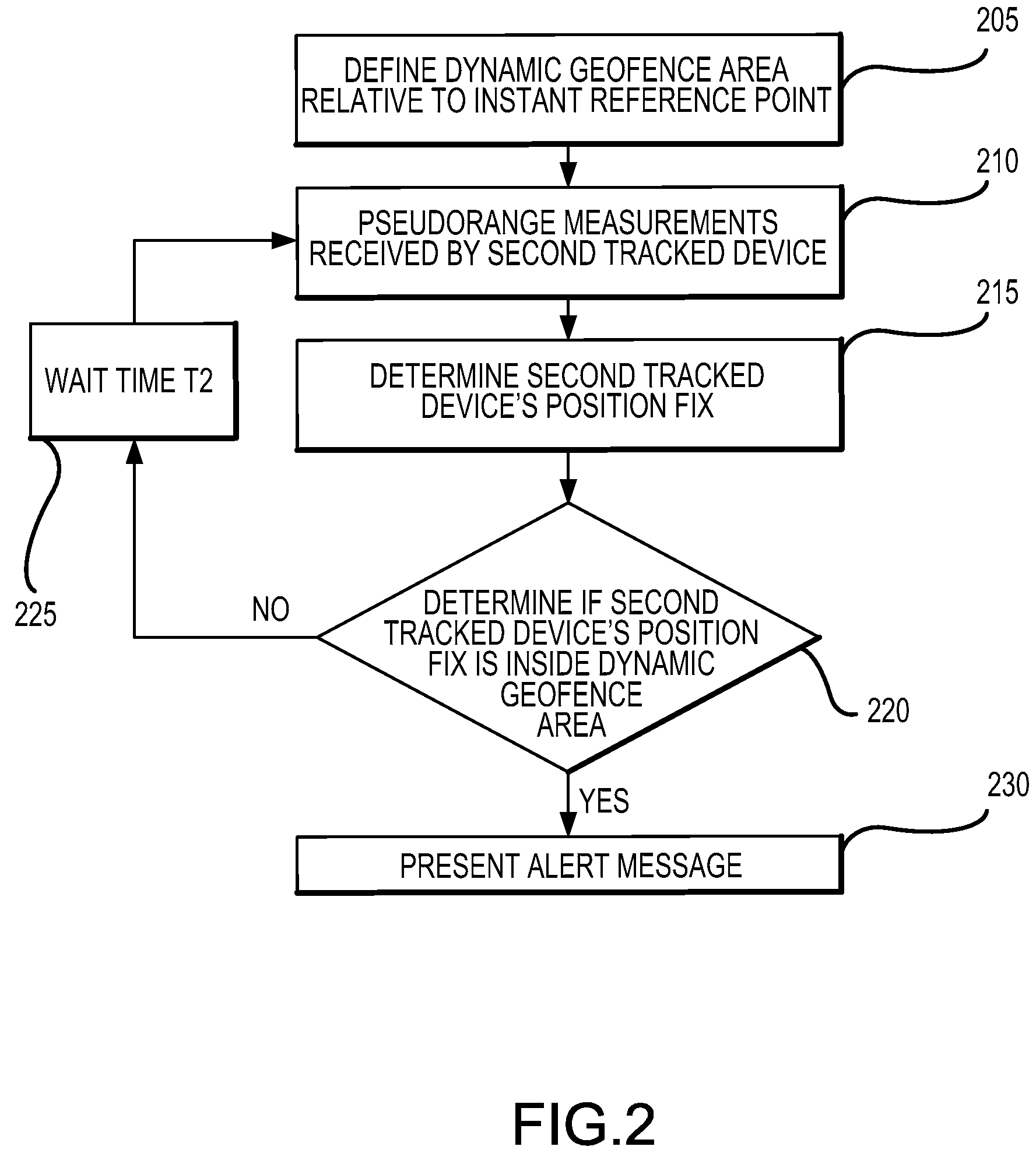
[0015]The detailed description set forth below in connection with the appended drawings is intended as a description of various aspects of the present invention and is not intended to represent the only aspects in which the present invention may be practiced. Each aspect described in this disclosure is provided merely as an example or illustration of the present invention, and should not necessarily be construed as preferred or advantageous over other aspects. The detailed description includes specific details for the purpose of providing a thorough understanding of the present invention. However, it will be apparent to those skilled in the art that the present invention may be practiced without these specific details. In some instances, well-known structures and devices are shown in block diagram form in order to avoid obscuring the concepts of the present invention. Acronyms and other descriptive terminology may be used merely for convenience and clarity and are not intended to li...


PUM


Abstract

A method and apparatus for creating a dynamic GeoFence area by determining an instant reference point using a first set of pseudorange measurements received by a GeoFence device, defining the dynamic GeoFence area referenced to the instant reference point, determining a position fix using a second set of pseudorange measurements, and comparing the position fix to the dynamic GeoFence area. In one aspect, an alert message based on the comparison results is presented to a user.

Description

FIELD[0001]This disclosure relates generally to apparatus and methods for wireless tracking of people, pets or assets. More particularly, the disclosure relates to dynamic creation of a GeoFence area in a wireless system.BACKGROUND[0002]GeoFence tracking is the monitoring of movement of targets such as personal assets, vehicles or personnel within a defined geographic boundary. GeoFence tracking is used to track and record the movement (such as entry or exit) of an assigned target from a geographic boundary and to alert a system user of the movement activities of the assigned target.[0003]A GeoFence boundary is generally referenced to a fixed location. Here, the system user redefines the geographic boundary or the reference point for the geographic boundary for each different area it would like to monitor. Thus, a new GeoFence boundary is defined each time. In a fixed GeoFence boundary, the system user cannot track an assigned target relative to another assigned target if both assig...

Claims


Application Information

Patent Timeline
Patent Type & Authority Applications(United States)
IPC IPC(8): G06F19/00G06F17/30H04W4/021
CPCG08B21/0227G08B21/0233H04W4/021G08B21/22G08B21/0261G08B21/02
Inventor HOLCMAN, ALEJANDRO R.ARYAN, BABAKSTEENSTRA, JACK B.
Owner QUALCOMM INC
Why Eureka
Try Eureka