Geospatial modeling system for images and related methods

a geospatial modeling and image technology, applied in image enhancement, image analysis, instruments, etc., can solve the problems of further deterioration of accuracy and undesirable low accuracy of geolocation data, and achieve the effect of more accurate geolocation data

Inactive Publication Date: 2010-05-13
HARRIS CORP
View PDF11 Cites 53 Cited by
  • Summary
  • Abstract
  • Description
  • Claims
  • Application Information

AI Technical Summary

Benefits of technology

[0009]In view of the foregoing background, it is therefore an object of the present invention to provide a geospatial modeling system with more accurate geolocation data.

Problems solved by technology

Although stereographic generation of DSMs using the overlapping images of a geographical area of interest may produce detailed results, there may be some potential drawbacks.
Although the images may be detailed, the geolocation data may have an undesirable low accuracy.
Indeed, once the images are stereographically processed to provide a DSM, the accuracy may further deteriorate, which may be undesirable in applications that depend on detailed DSMs.

Method used


Image

  • Geospatial modeling system for images and related methods
  • Geospatial modeling system for images and related methods
  • Geospatial modeling system for images and related methods

Examples


Embodiment Construction

[0031]The present invention will now be described more fully hereinafter with reference to the accompanying drawings, in which preferred embodiments of the invention are shown. This invention may, however, be embodied in many different forms and should not be construed as limited to the embodiments set forth herein. Rather, these embodiments are provided so that this disclosure will be thorough and complete, and will fully convey the scope of the invention to those skilled in the art. Like numbers refer to like elements throughout.

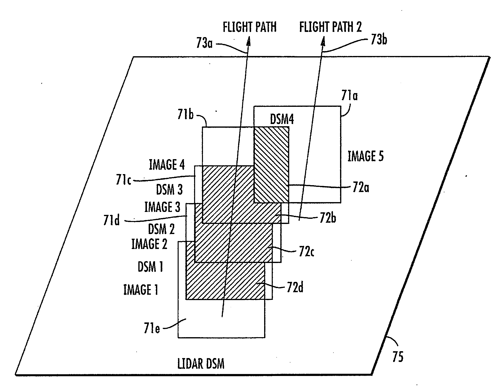
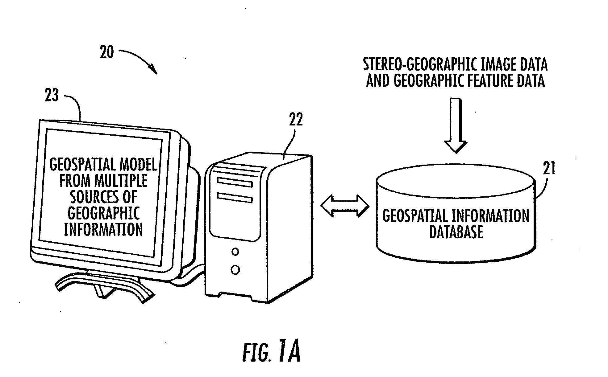
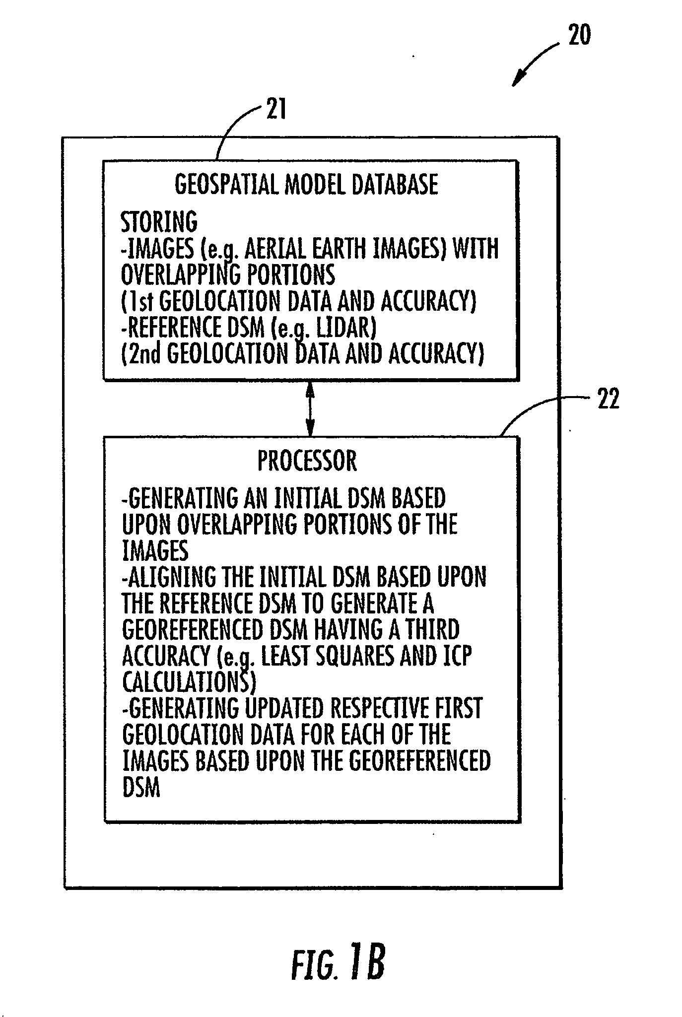
[0032]Referring initially to FIGS. 1-5, a geospatial modeling system 20 according to the present invention is now described. Moreover, with reference to the flowchart 30 of FIG. 2, another aspect directed to a computer implemented method for geospatial modeling is also now described, which begins at Block 31. The geospatial modeling system 20 illustratively includes a geospatial model database 21, a processor 22, illustrated as a personal computer (FIG. 1a...


PUM


Abstract

A geospatial modeling system may include a geospatial model database for storing images of a geographical area and a reference digital surface model (DSM) of the geographical area. The images each have associated with them respective first geolocation data with a first accuracy. The reference DSM may include second geolocation data with a second accuracy being greater than the first accuracy. The geospatial modeling system may further include a processor cooperating with the geospatial model database for generating an initial DSM based upon overlapping portions of the images, and aligning the initial DSM based upon the reference DSM to generate a georeferenced DSM having a third accuracy greater than the first accuracy.

Description

FIELD OF THE INVENTION[0001]The present invention relates to the field of geospatial modeling, and, more particularly, to geospatial modeling of images and a digital surface model and related methods.BACKGROUND OF THE INVENTION[0002]Topographical models of geographical areas may be used for many applications. For example, topographical models may be used in flight simulators and other planning missions. Furthermore, topographical models of man-made structures, for example, cities, may be extremely helpful in applications, such as, cellular antenna placement, urban planning, disaster preparedness and analysis, and mapping.[0003]Various types of topographical models are presently being used. One common topographical model is the digital elevation model (DEM). A DEM is a sampled matrix representation of a geographical area, which may be generated in an automated fashion by a computer. In a DEM, coordinate points are made to correspond with a height value. DEMs are typically used for mo...

Claims


Application Information

Patent Timeline
Patent Type & Authority Applications(United States)
IPC IPC(8): G06T17/50G06T17/05
CPCG01C11/06G06T2207/30184G06T17/05G06T7/0028G06T7/33
Inventor KARP, JOHNMCDOWALL, TOMRAHMES, MARK
Owner HARRIS CORP
Why Eureka
Try Eureka