System and method for viewing and correcting data in a street mapping database

a street mapping and database technology, applied in the field of system and method for updating street data and identifying errors in the database, can solve problems such as reporting errors in street mapping data

Active Publication Date: 2010-08-19
IWI
View PDF121 Cites 96 Cited by
  • Summary
  • Abstract
  • Description
  • Claims
  • Application Information

AI Technical Summary

Benefits of technology

[0003]These and other problems are generally solved or circumvented, and technical advantages are generally achieved, by preferred embodiments of the present invention in whi

Problems solved by technology

The driver may then evaluate the accuracy of the street map

Method used


Image

  • System and method for viewing and correcting data in a street mapping database
  • System and method for viewing and correcting data in a street mapping database
  • System and method for viewing and correcting data in a street mapping database

Examples


Embodiment Construction

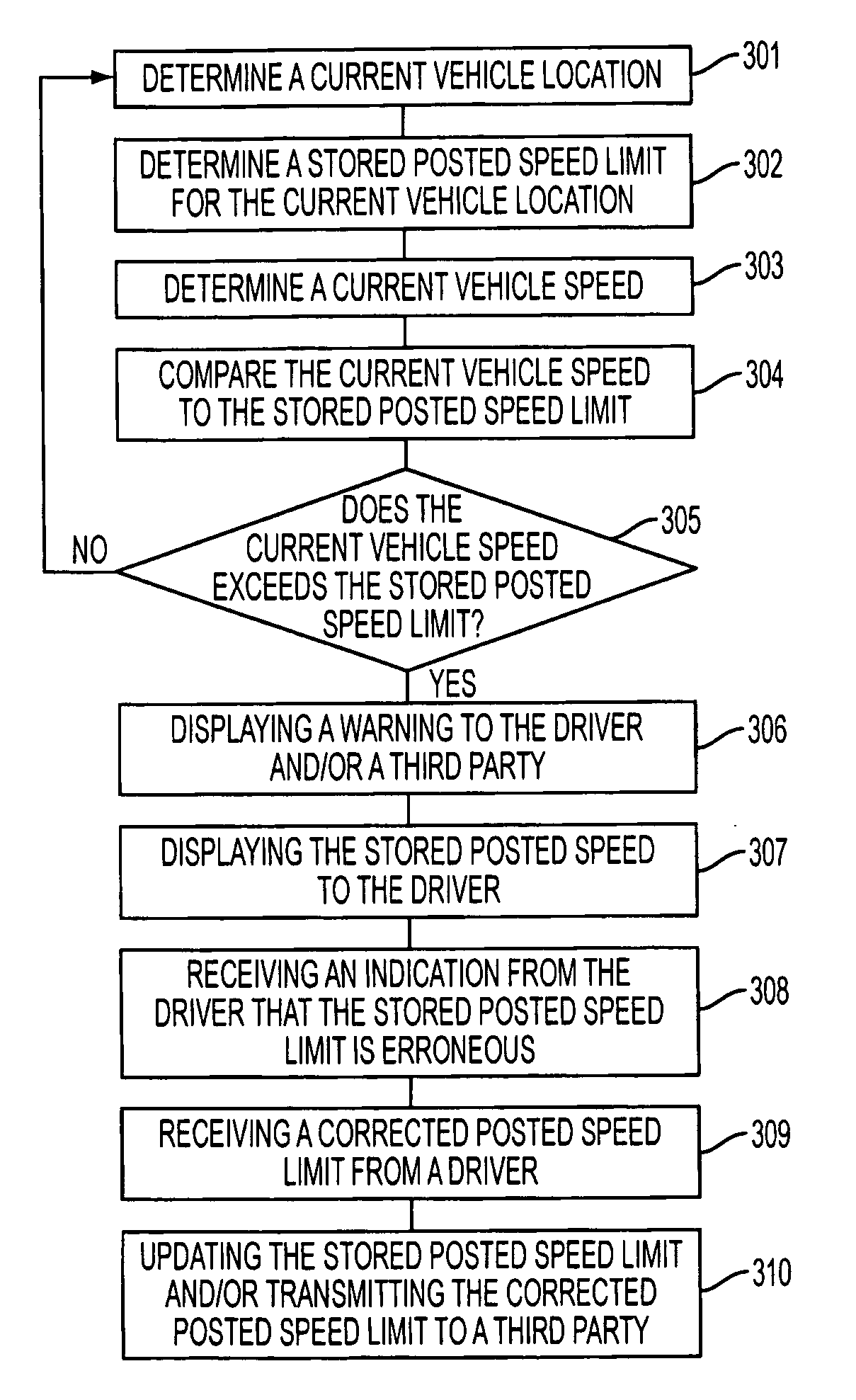
[0015]The present invention provides many applicable inventive concepts that can be embodied in a wide variety of specific contexts. The specific embodiments discussed are merely illustrative of specific ways to make and use the invention, and do not limit the scope of the invention.

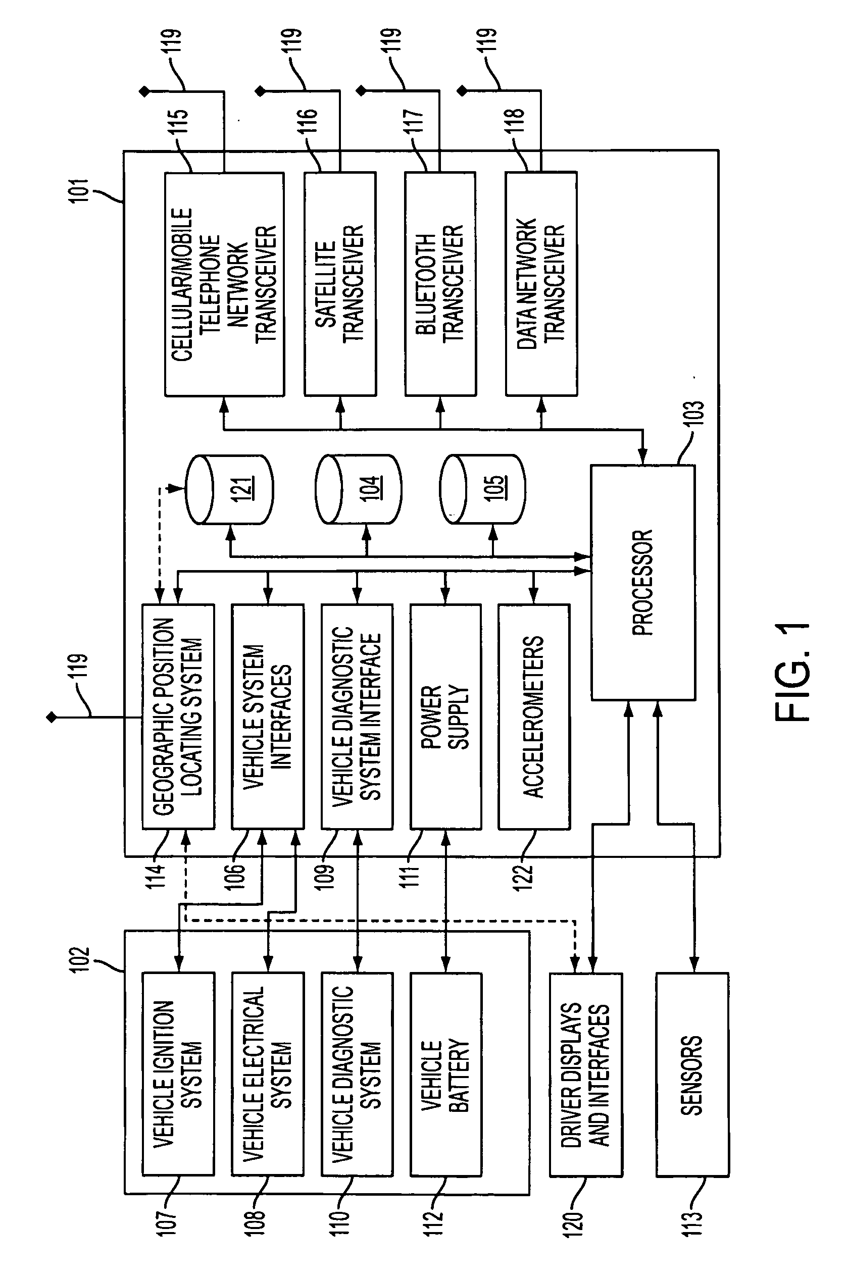
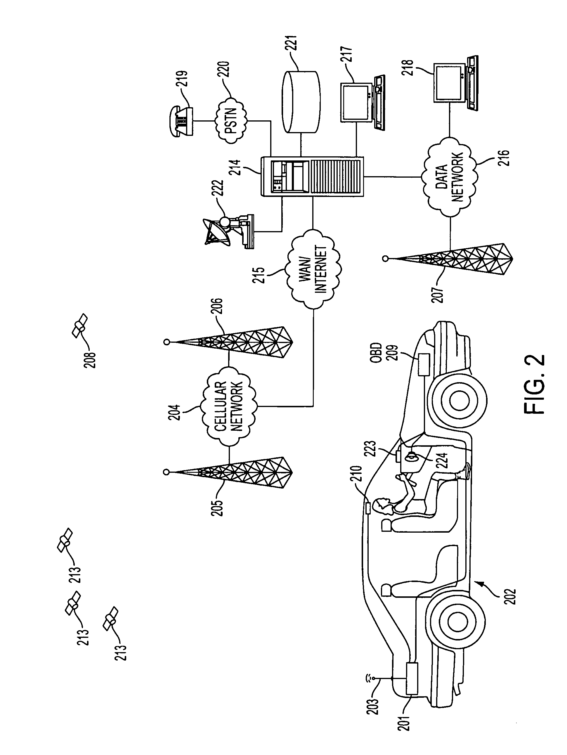
[0016]With reference to FIG. 1, there is shown vehicle monitoring unit 101 that is coupled to one or more systems in vehicle 102. Processor 103 controls the operation of monitoring unit 101. Processor 103 may be a general use processing device having software designed to control unit 101. Alternatively, processor 103 may be a specially designed circuit or device, such as an application specific integrated circuit (ASIC), that is particularly designed for use in unit 101. Processor 103 may use firmware or software, such as an operating system, for control and operation. Operating firmware, software and other data may be stored in random access memory (RAM) 104, read only memory (ROM) 105, electrically era...


PUM


Abstract

A system and method for detecting use of a wireless device is disclosed. In one embodiment, a system and method for using street map data broadcasts a warning to a driver, wherein the warning is triggered when a vehicle operating parameter does not comply with a limitation for a current street in a street mapping database. The limitation for the current street is also broadcast to the driver. An indication that the limitation for the current street is incorrect is received from the driver. The warning to the driver may be an audible warning and/or a visual warning to the driver. Broadcasting a limitation for the current street may include displaying the limitation to the driver or playing a spoken message to the driver. The limitation may be a posted speed limit or a traffic direction, for example.

Description

TECHNICAL FIELD[0001]The present invention relates generally to a system and method for creating, using and maintaining a database of street mapping data and, more particularly, to a system and method for updating street data and identifying errors in the database.BACKGROUND[0002]Detailed street mapping data is available from companies such as NavTeq and Tele Atlas. The street mapping data may include street location, street names, posted speed limits, numbers of lanes, travel direction, and other information. This street mapping data is used in vehicle navigation systems to provide map displays and other information to drivers. Typically, the only information displayed to a driver is a street map and limited other information, such as the name of the street being used by a vehicle and / or the name of the city or municipality in which the street is located. Other street mapping data may be available for a current street or roadway, but that information is not available to the driver....

Claims


Application Information

Patent Timeline
IPC IPC(8): B60Q1/00
CPCG01C21/3697G01C21/32G01C21/3848G01C21/3837
Inventor FOLLMER, TODD W.MCCLELLAN, SCOTT
Owner IWI
Why Eureka
Try Eureka