Forming a geological model

a geological model and model technology, applied in the field of geological model formation, can solve the problems of not being able to capture the three dimensional structural uncertainty in the structural model, the measurement position of wells is then less reliable, and the problem of capturing the three dimensional structural uncertainty remains

Active Publication Date: 2010-12-30
EQUINOR ENERGY AS
View PDF40 Cites 58 Cited by
  • Summary
  • Abstract
  • Description
  • Claims
  • Application Information

AI Technical Summary

Problems solved by technology

One caveat with this method is its lack of ability to capture the three dimensional uncertainty in the structural model.
The second assumption (referred to as ‘vertical stretch’ since only the depth dimension is influenced in the structural imaging) can be bypassed with more complicated depth conversion methods, for instance by using ray tracing, but the problem of capturing the three dimensional structural uncertainty remains.
The measured positions of wells are then less reliable.
This means that the well marker data cannot be treated as fixed, known geographical positions, simply used to scale the seismic data from time to depth domain.
The main limitation of current technology is including the well marker position and position accuracy into the broader picture of three dimensional positioning.
Tools for representing seismic data in east, north and depth coordinates and integrating these data with geographical well marker data have been lacking, particularly at the level where one can deduce the three dimensional positioning uncertainty.
For almost flat horizons, this gives a reliable method but, for dipping layers, curved surfaces or faults, this can introduce bias.
Methods for orthogonal shifting of dipping surfaces have been proposed, but this is still an ad-hoc technique that does not capture intrinsic direction variability that can actually be physically modelled using, for instance, ray-tracing.
Hence, updating the geographical model is by current standards a tedious process with too much work being done on reiterating the data and trying to match information that cannot be unified.

Method used


Image

  • Forming a geological model
  • Forming a geological model
  • Forming a geological model

Examples


Embodiment Construction

Introduction

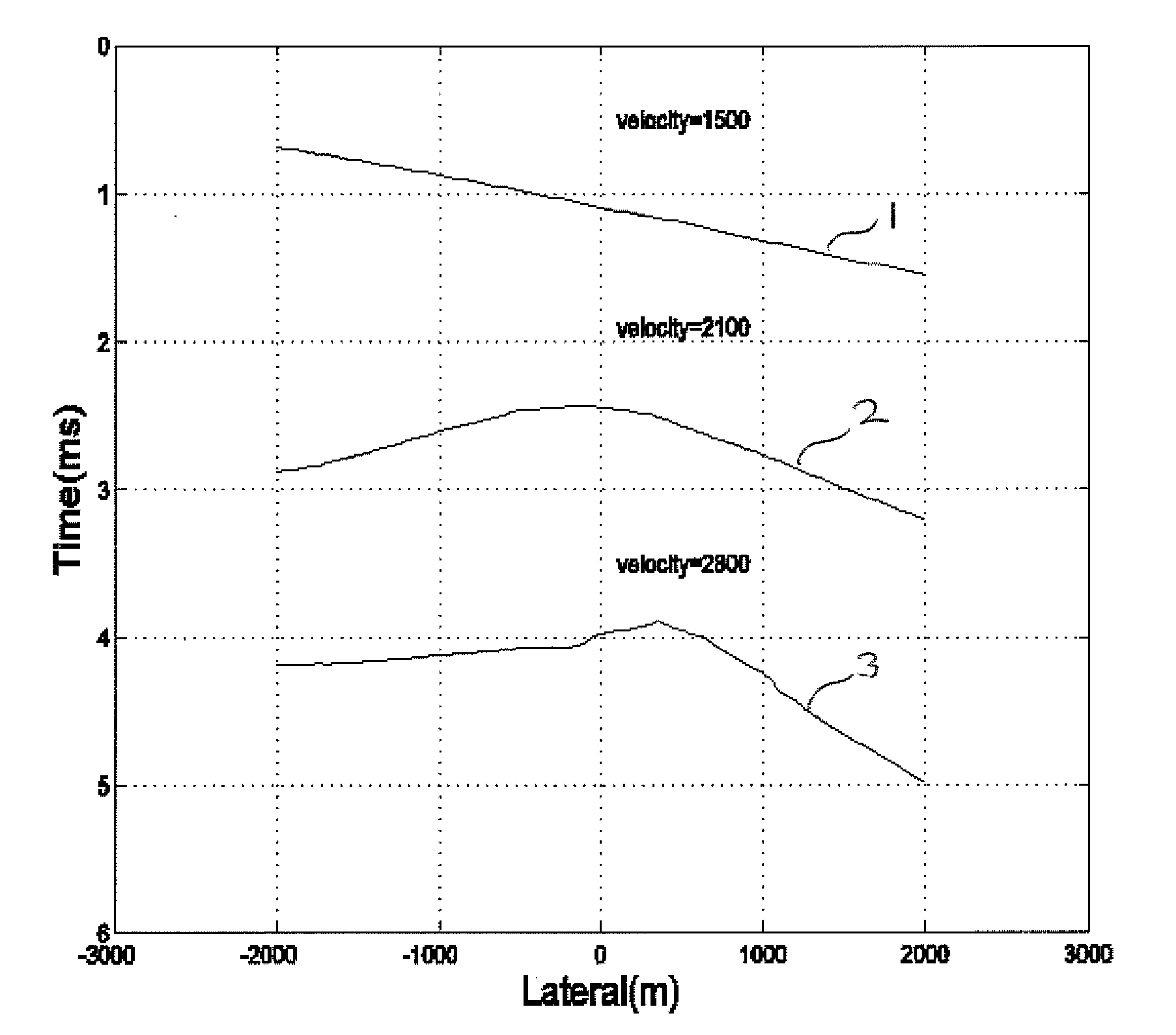
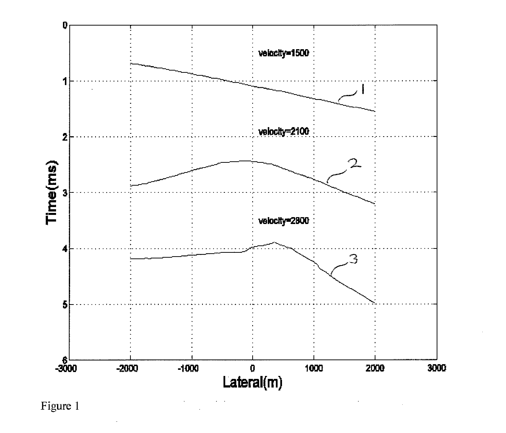
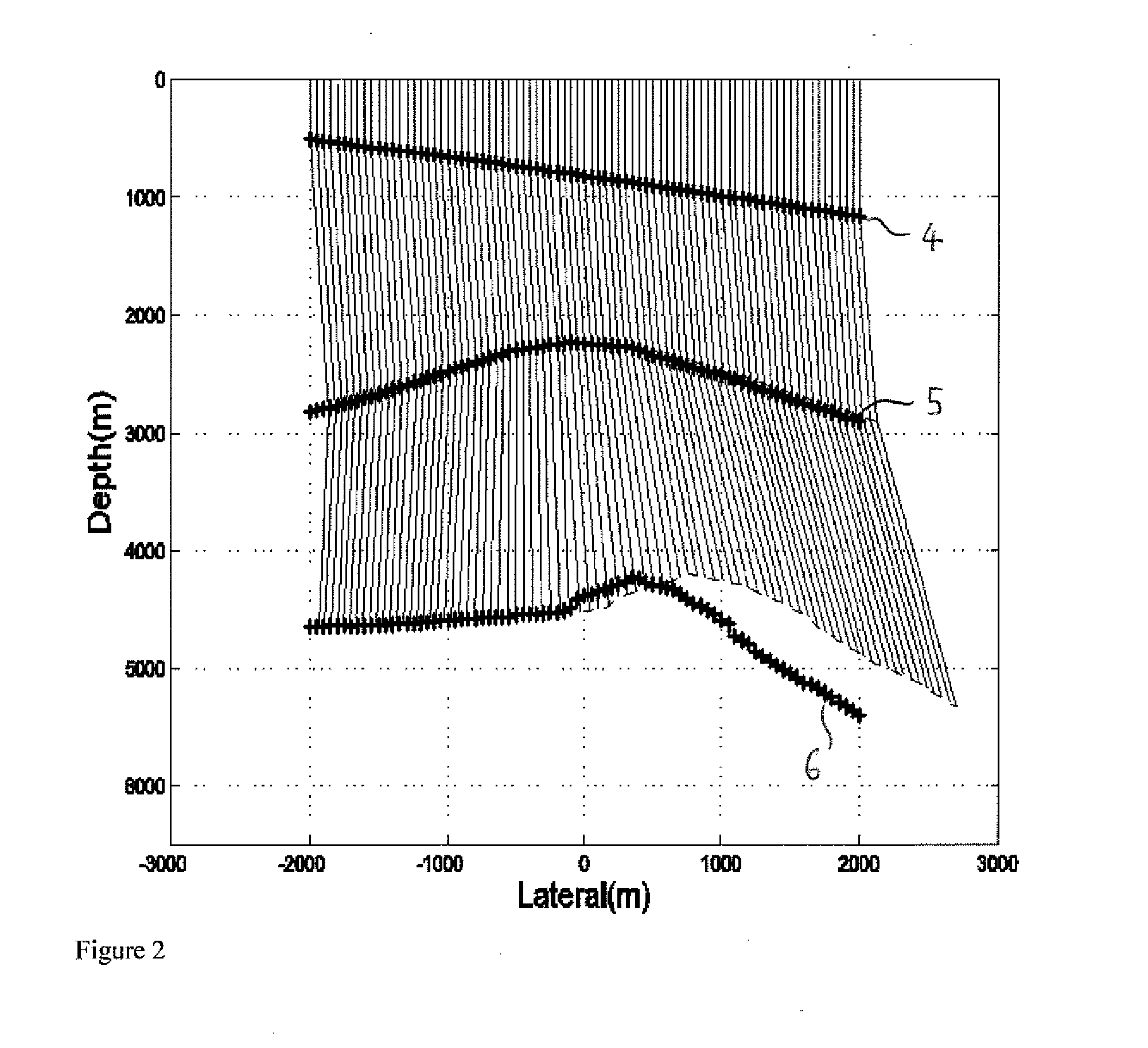
[0083]Reliable prediction of subsurface faults and horizons is of major importance for the petroleum industry. Both the best estimates and the uncertainty of positions are of high importance in several decision processes. One such process is well planning where this information influences the shape of well trajectories and also the shape and position of drilling targets (Haarstad et al. 2002; Prange et al., 2004). The positional uncertainty of structures is crucial information both in planning the acquisition of new subsurface data for better subsurface understanding, and in the process of planning the drainage strategy of a reservoir. Estimates of horizon and fault positions, as well as their uncertainties, is an important input for prediction of in place volume estimates.

[0084]Today most well calibration methods rely on changing the seismic velocity model until it mostly fits a set of well-measured velocities. This is a time consuming process with a lot of human intera...


PUM


Abstract

A method of forming a geological model of a region of the earth includes obtaining seismic data relating to the region, the seismic data including seismic traveltime uncertainty. A seismic velocity model of the region may also be provided and includes velocity uncertainty. Ray tracing may be performed on the seismic data using the velocity model to determine the three dimensional positions of a plurality of points of the region. The three dimensional positional uncertainties (7-12) of at least some of the points can be calculated from the traveltime uncertainty, the velocity uncertainty, and uncertainty in the ray propagation direction. This can be combined with the positions determined by the ray tracing to form a geological model.

Description

TECHNICAL FIELD OF THE INVENTION[0001]The present invention relates to a method of forming a geological model.BACKGROUND OF THE INVENTION[0002]Seismic traveltime data and well marker data are integrated in many petroleum reservoirs for improved knowledge of oil-in-place, hydrocarbon heterogeneities, risk evaluation, and in general for making better decisions about both drilling and drainage strategies. The way seismic and well data are integrated differs dramatically and depends heavily on the main objective of study. To obtain the best out of the data, one must take into account the uncertainty associated with each data type. Consider for instance the thickness of an oil reservoir; One data source (wells) tells you it is 30 m, the second (seismic) says 50 m. How much is this reservoir worth in terms of net present value? Should we start producing hydrocarbons? If the critical thickness based on the cost and expected revenues is 40 m, we would have to trust the first source less tha...

Claims


Application Information

Patent Timeline
Patent Type & Authority Applications(United States)
IPC IPC(8): G01V1/30
CPCG01V1/282G01V1/305G01V2210/667G01V2210/66
Inventor BRUUN, BJORN TORSTEINNYRNES, ERIKEIDSVIK, JO
Owner EQUINOR ENERGY AS
Why Eureka
Try Eureka