Method and system for determining clock corrections

a technology of clock correction and satellite navigation system, which is applied in the field of method and system for determining clock correction for satellite navigation system, can solve the problems of prior art approach requiring expensive atomic clocks and inaccurate position estimation, and achieve the effect of facilitating the determination of accurate position estimates

Active Publication Date: 2012-07-19
DEERE & CO
View PDF1 Cites 61 Cited by
  • Summary
  • Abstract
  • Description
  • Claims
  • Application Information

AI Technical Summary

Benefits of technology

[0007]In accordance with one embodiment, a method and system for determining satellite clock corrections facilitates the determination of accurate position estimates by one or more mobile location-determining receivers. The method and system comprises collecting pseudo-range code measurements, carrier-phase measurements, and navigation message data (e.g., broadcast clock error data or broadcast clock offset) from a network of stationary receivers of satellite signals transmitted by one or more constellations of navigation satellites. At each time interval (e.g., an epoch), a clock error is computed for each navigation satellite based on the collected pseudo-range code measurements, the carrier phase measurements, and the navigation message data. Clock error differences are formed between the computed satellite clock error and the broadcast clock error for each satellite. For each constellation, a clock reference satellite is selected, from among the navigation satellites in that constellation, that has the median value of clock error difference for that satellite constellation. A correction to the broadcast clock error of each satellite in that constellation is then determined by adding a function of the clock reference satellite's clock error to the broadcast clock error for each satellite in that constellation (e.g., on a satellite-by-satellite basis within each constellation). The value of the correction at each epoch or other time interval (e.g., several epochs) is limited based on a control parameter limit (e.g., where the control parameter limit is less than or approximately equal to the clock reference satellite's clock error, or where the control parameter limit comprises a fixed parameter, expressed in distance units, as a Kalman filter solution converges on solution for the broadcast clock error).

Problems solved by technology

The location-determining receiver may derive imprecise positions and velocities due to inaccurate clock data from one or more satellites.
In practice, this prior art approach requires expensive atomic clocks to be located at several different sites with network receivers.

Method used


Image

  • Method and system for determining clock corrections
  • Method and system for determining clock corrections
  • Method and system for determining clock corrections

Examples


Embodiment Construction

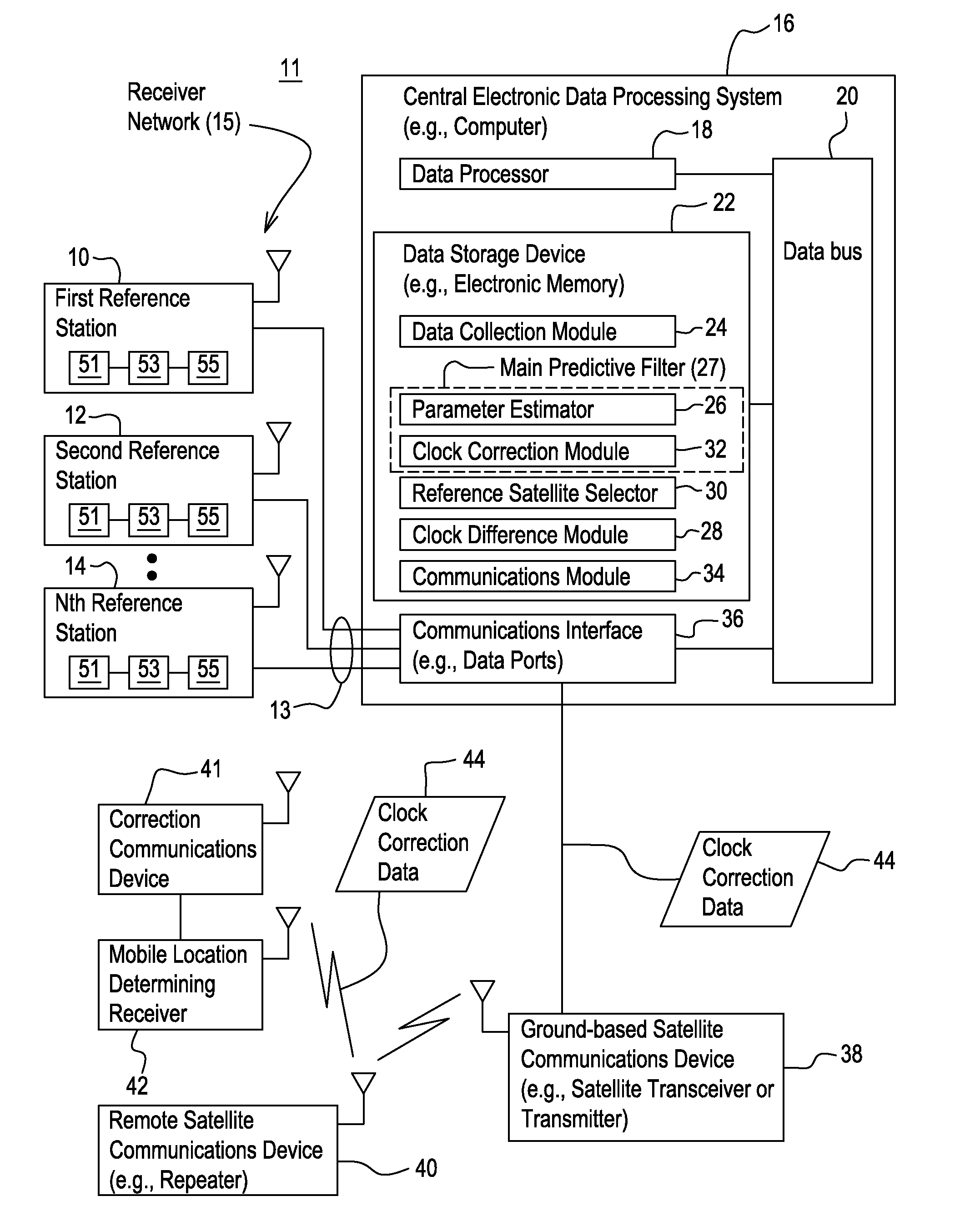
[0014]In accordance with one embodiment of a system 11 for determining clock corrections for a satellite navigation system (e.g., GNSS system), the system 11 facilitates the real-time determination of accurate and smooth satellite clock corrections to broadcasted satellite clock error data to support enhanced reliability and accuracy of mobile location-determining receivers 42 that can use clock correction data 44 in real-time. The method and system produces clock correction data 44 (e.g., clock error corrections) that is well suited for providing enhanced accuracy and resolution in determining the position or velocity of a mobile location-determining receiver 42, or an associated object, in real-time.

[0015]In one embodiment, the system 11 comprises a receiver network 15 that is capable of communication with a central electronic data processing system 16 via one or more communications links 13. The central electronic data processing system 16 is coupled to a ground-based satellite c...


PUM


Abstract

A satellite clock error is determined for each navigation satellite based on the pseudo-range code measurements, the carrier phase measurements, and broadcast satellite clock errors provided by a receiver network. Differences are determined between the computed satellite clock errors and the broadcast clock errors for each satellite. For each constellation, a clock reference satellite is selected from among the navigation satellites, where the clock reference satellite has the median value of clock error difference for that satellite constellation. A correction is determined for the broadcast clock error by applying a function of the reference satellite's clock error to the broadcast clock error for each satellite in the one or more constellations.

Description

[0001]This document claims priority based on U.S. provisional application Ser. No. 61 / 432,646, filed on Jan. 14, 2011 and entitled METHOD AND SYSTEM FOR DETERMINING CLOCK CORRECTIONS, under 35 U.S.C. 119(e).FIELD OF THE INVENTION[0002]This invention relates to a method and system for determining clock corrections for a satellite navigation system.BACKGROUND OF THE INVENTION[0003]A location-determining receiver, such as a Global Navigation Satellite System (GNSS) receiver, can estimate the position and velocity of an object or a vehicle. The location-determining receiver may derive imprecise positions and velocities due to inaccurate clock data from one or more satellites. GNSS augmentation systems that distribute corrections for GNSS errors provide user receivers with information that enables more accurate navigation than otherwise possible. Such augmentation systems typically include clock and orbit corrections to the transmitted satellite clock and orbit information.[0004]A GNSS a...

Claims


Application Information

Patent Timeline
Patent Type & Authority Applications(United States)
IPC IPC(8): G01S19/48
CPCG01S19/41G01S19/07
Inventor DAI, LIWEN L.ZEITZEW, MICHAEL A.CHEN, YIQUNZHANG, YUJIE
Owner DEERE & CO
Why Eureka
Try Eureka