Subsurface Directional Equalization Analysis of Rock Bodies

a technology of subsurface directional equalization and rock bodies, which is applied in the direction of instruments, analogue processes for specific applications, geomodelling, etc., can solve the problems of limited logging data prediction of facies at non-cored wells, inability to achieve seismic imaging at the required resolution, and many technical limitations in the workflow

Inactive Publication Date: 2012-09-20
SAUDI ARABIAN OIL CO
View PDF4 Cites 15 Cited by
  • Summary
  • Abstract
  • Description
  • Claims
  • Application Information

AI Technical Summary

Benefits of technology

[0015]The present invention also provides a new and improved data storage device having stored in a computer readable medium computer operable instructions for causing a processor to perform subsurface directional analysis of an area of interest with rock bodies having geological trends in the earth. The processor has as input data geobody and categorical data regarding the area of interest. The instructions stored in the data storage device cause the processor to form a measure of postulated proportions of rock joint events in the geological trends in the area of interest and form a measure of spatial tensorial relations for projections along directions of the geological trends in the area of interest based on the measure of postulated proportions of rock joint events. The instructions stored in the data storage device cause the processor to project the categorical data onto the measure of spatial tensorial relations and determine cross-structural relationships between the projected categorical data and the measure of spatial tensorial relations for expected pairs of directions and rock categories. The instructions stored in the data storage device further cause the processor to equalize the measure of spatial tensorial relations and the projected categorical data to form a meta-model of facies present in the area of interest and their directions, and form a record of the meta-model of facies.

Problems solved by technology

A number of technical limitations have been identified in the workflows.
The main difficulty is that reservoir rocks are located at some several thousand feet in the subsurface.
Therefore, seismic imaging at the required resolution is not possible yet.
Furthermore, the amount of rock cores that can be available at a given reservoir is not large, and prediction of facies at non-cored wells from logging data may be limited by the logging tool resolution.
In addition to data collection limitations, there are computational limitations imposed by the mathematical approaches utilized for numerical analysis and modeling.
While such a product is valid for the Markovian model, it is rarely valid in realistic rock sequences.
Facies analysis modeling also faces similar limitations.
It has been proposed that higher order connectivity could relax the limitation of SIS but a theoretical solution with higher order moments is intractable.
Another way around the second order limitation of SIS was by using Boolean object modeling methods where the geobodies geometry was statistically simulated.
The problem became a puzzle if bodies had to align with complex trends observed in well data.
This was an issue when using object modeling with a large number of wells.
As a consequence, the data conditioning process with simulated annealing for hundreds of wells could take hundreds of hours of computer time.

Method used


Image

  • Subsurface Directional Equalization Analysis of Rock Bodies
  • Subsurface Directional Equalization Analysis of Rock Bodies
  • Subsurface Directional Equalization Analysis of Rock Bodies

Examples


Embodiment Construction

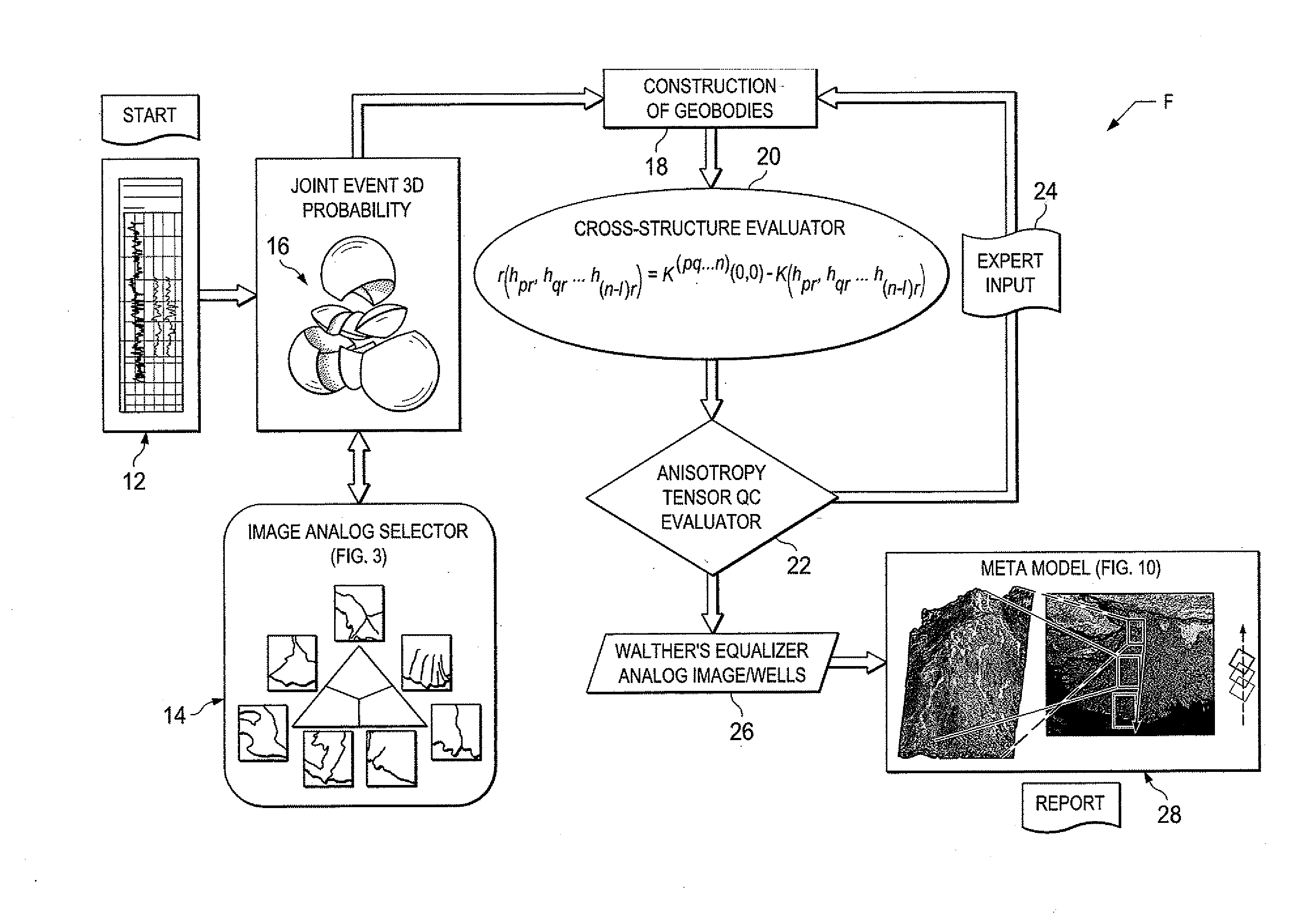
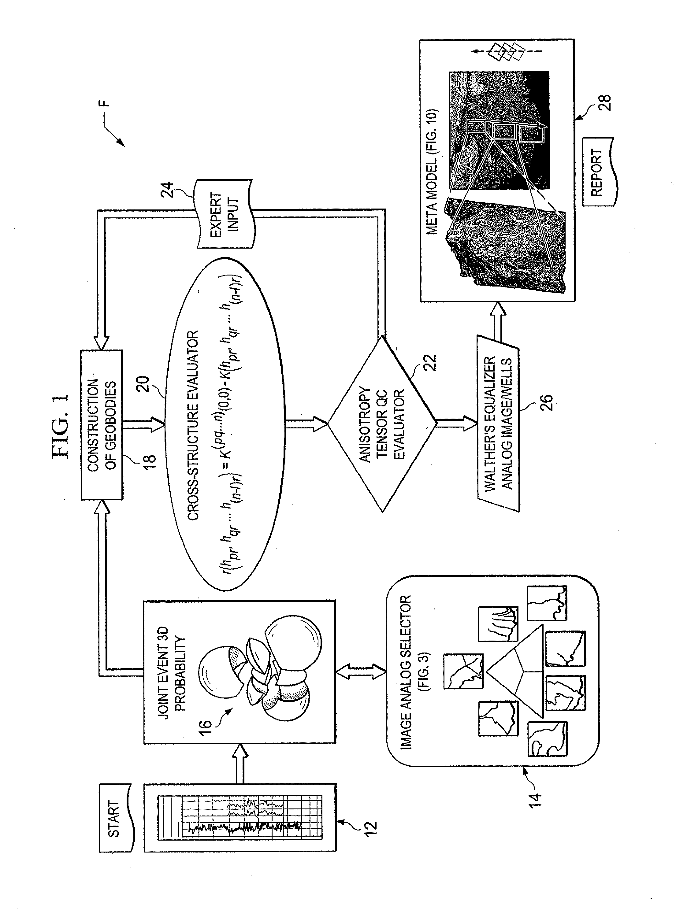
[0026]In the drawings, FIG. 1 is a diagram or flow chart F of data processing steps according to the present invention. As will be set forth, the present invention provides subsurface directional analysis for forming an image based facies three-dimensional (3D) meta-model with unbiased vectors and tensor relations among rock bodies or complex objects in the directional subsurface depositional environment. The present invention provides novel physical-spatial-statistical analytical computer modeling tools which are applied to sequence stratigraphy for the characterization of geological heterogeneity of developed industrial oil / gas reservoirs, aquifers and sequences of rocks in the subsurface.

[0027]As shown in the flow chart F of FIG. 1, a preferred sequence of steps of a computer implemented method or process according to the present invention is illustrated schematically. The flow chart F is a high-level logic flowchart illustrates a method according to the present invention of form...


PUM


Abstract

A subsurface directional analysis determines an image-based three-dimensional analysis meta-model with unbiased vectors and tensor relations among rock bodies or complex objects in the directional subsurface environment. An analytical tool is applied to sequence stratigraphy for characterization of geological heterogeneity of developed hydrocarbon reservoirs, aquifers and sequences of rocks.

Description

BACKGROUND OF THE INVENTION[0001]1. Field of the Invention[0002]The present invention relates to determining models of the relationship of rock bodies or complex objects in the earth to evaluate recoverable hydrocarbons and other geological information of interest.[0003]2. Description of the Related Art[0004]Ultimate recovery of hydrocarbons from reservoir fluids heavily depends on the three dimensional (3D) delimitation of rock bodies. The spatial distribution and flow of fluids must be constrained to the spatial delimitation of rock type regions and properties (i.e., petrophysical properties and fluid saturation geocellular models). The exact spatial location of rock bodies at non-sampled locations is almost unpredictable, and one must resort to high-frequency sequence stratigraphy that can be used for advanced probability studies and predictions of sedimentary deposition.[0005]State of the art facies analysis has so far as is known been based on the following workflow: (a) Core d...

Claims


Application Information

Patent Timeline
Patent Type & Authority Applications(United States)
IPC IPC(8): G06G7/48
CPCG06T17/05G06T11/206G01V99/005
Inventor VARGAS-GUZMAN, J.A.
Owner SAUDI ARABIAN OIL CO
Why Eureka
Try Eureka