GPS/IMU/Video/Radar absolute/relative positioning communication/computation sensor platform for automotive safety applications

a technology of automotive safety and communication, applied in the field of absolute/relative positioning platforms and associated computations for safety applications, can solve the problems of lack of positioning accuracy, low accuracy of current gps navigation devices, and inability to integrate with other sensors, so as to achieve safety situational awareness and prevent unavoidable accidents

Active Publication Date: 2012-11-15
UATC LLC
View PDF24 Cites 133 Cited by
  • Summary
  • Abstract
  • Description
  • Claims
  • Application Information

AI Technical Summary

Benefits of technology

[0005]The proposed architecture allows the central data fusion processor to process all the measurements simultaneously in order to estimate the host vehicle position within a single lane and its orientation and to establish safety situational awareness in the neighborhood of the host vehicle using the data from a GPS / IMU processor, odometer, video cameras, radar sensor(s), other sensors installed in the host vehicle and data from the other cars in the network. When unsafe vehicle driver behavior is identified or unsafe driving conditions are detected in the neighborhood of the host vehicle, the warning module of the data fusion processor will issue safety warnings to the neighboring cars through the V2V communication module and / or to the rest of the network through the V2I communication module. Optionally, the data fusion processor will include an automated safety module able to issue commands to the vehicle controls to prevent unavoidable accidents, and a warning module to issue visual and / or audio warnings to the driver.

Problems solved by technology

Because of the low GPS positioning accuracy, the car GPS navigational devices are not used for roadway safety applications.
The various devices installed in the cars today including radar sensors, video cameras, GPS devices, odometers process the information independently and do not combine all this information optimally in a central processor either installed inside a host vehicle (moving vehicle) or in a cloud-server to determine absolute position and orientation (pitch, yaw and roll) of a host vehicle (moving vehicle) and its relative position and orientation (pitch, yaw and roll) relative to the other cars (vehicles) in the network.
The current GPS navigation devices have low accuracy and they are not integrated with the other sensors, such as odometers, Inertial Navigation (Measurement) (IMUs), video cameras for safety applications, relative-positioning devices (e.g., radars), Vehicle-To(2)-Vehicle (V2V), and Vehicle-To(2)-Infrastructure(V2I) communications.
The lack of positioning accuracy, the absence of orientation information and the lack of integration with other sensors, such as those mentioned above, prevent the current GPS navigation devices from being used for safety applications aiming to reduce and / or to eliminate accidents, by issuing warnings to the drivers, or directly interfacing with the controls of the host vehicle to prevent unavoidable accidents.

Method used


Image

  • GPS/IMU/Video/Radar absolute/relative positioning communication/computation sensor platform for automotive safety applications
  • GPS/IMU/Video/Radar absolute/relative positioning communication/computation sensor platform for automotive safety applications
  • GPS/IMU/Video/Radar absolute/relative positioning communication/computation sensor platform for automotive safety applications

Examples


Embodiment Construction

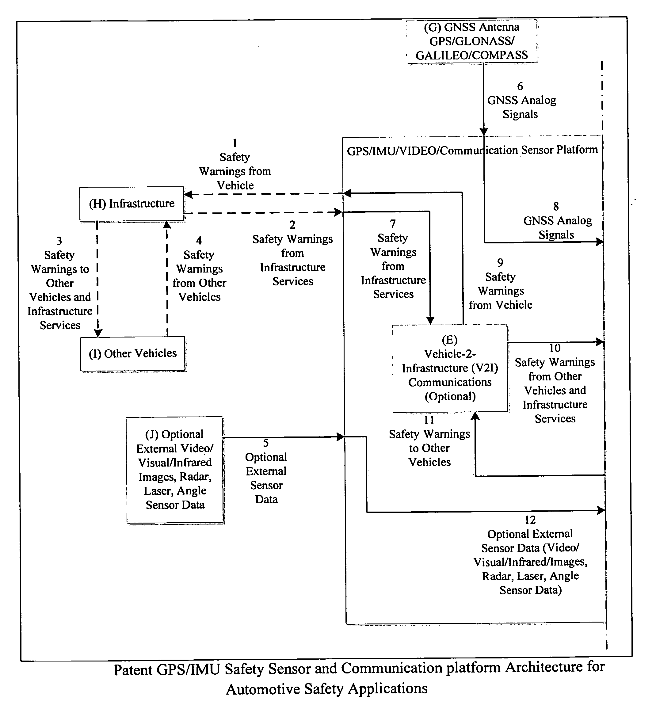
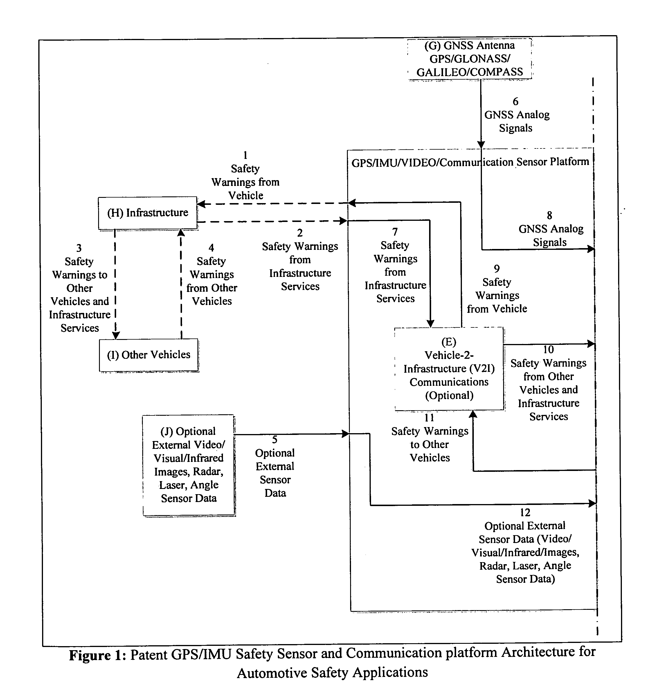
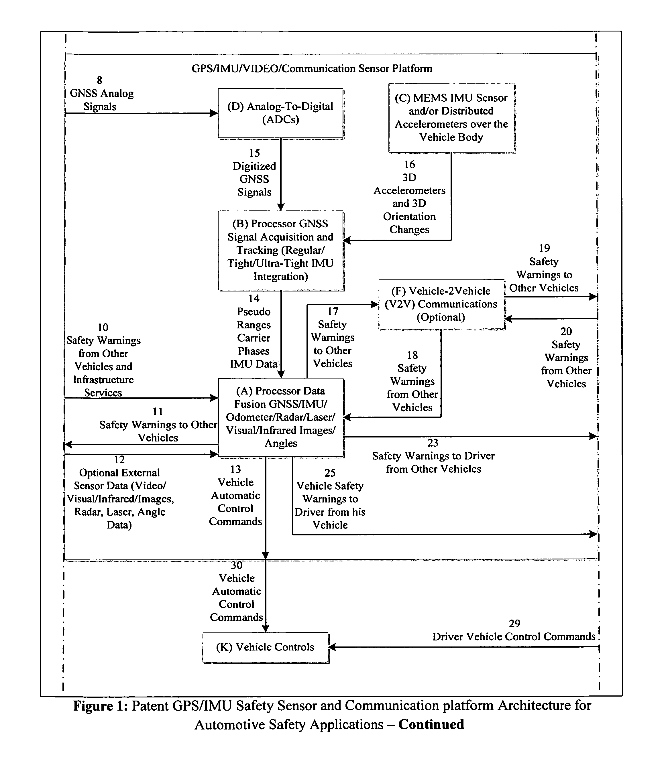
[0010]The proposed GPS / IMU Safety Sensor and Communication platform for Automotive Safety Applications, shown in FIG. 1, provides an open architecture to interface with video camera(s), radar / laser sensor(s), GPS / IMU data from other vehicles, odometer, other vehicle-to-vehicle relative positioning devices and V2V and the V2I communication modules. The GPS / IMU device will estimate in real-time the vehicle position within a single lane of the road and the vehicle orientation (i.e., pitch, yaw and roll). The lasers / radars and / or the video visual / infrared cameras, and / or GNSS / IMU data (GNSS carrier phases, GNSS pseudo-ranges, 3D / 2D orientation and acceleration rates) from other vehicles will be used to determine the relative position of the current vehicle with respect to rest of the vehicles in the traffic network.

[0011]All these data sources are fused together at the measurement level to estimate optimally the host vehicle orientation, vehicle position within a single lane, and the re...


PUM


Abstract

A GPS/IMU safety sensor platform is proposed, consisting of data fusion Processors, GNSS Signal Acquisition and Tracking Processors, MEMS IMU sensors, one or multiple accelerometers able to provide orientation information, optional V2V communication modules, and optional V2I communication modules. The data fusion processors provide interface ports to GNSS/IMU processors, odometers, video (Visual/Infrared) cameras installed in the vehicle, V2V relative positioning sensors (laser, radar or any other distance measuring), and V2V and V2I communication modules. The data fusion processors are interfaced to a driver warning system and optionally to the vehicle controls for providing safety warning messages to drivers, or for automatic control the vehicle for preventing and reducing accidents.

Description

BACKGROUND OF INVENTION[0001]The current invention is in the technical field of the positioning platforms (absolute / relative) and associated computations for safety applications in the automotive industry. More particularly this invention is in the field of absolute / relative GPS / GNSS / Odometer / IMU / Radar / Video absolute / relative positioning devices for safety applications in the automotive industry.[0002]The navigational devices installed in the cars today are GPS devices with an accuracy ranging from 2-3 meters to 10-15 meters. Because of the low GPS positioning accuracy, the car GPS navigational devices are not used for roadway safety applications. These GPS navigational devices are only used for navigational purposes providing directions to navigate the cars from the current location to a user predefined destination. The various devices installed in the cars today including radar sensors, video cameras, GPS devices, odometers process the information independently and do not combine ...

Claims


Application Information

Patent Timeline
Patent Type & Authority Applications(United States)
IPC IPC(8): G06F17/00G08G1/16
CPCG08G1/163G08G1/164B60T2210/36G01C21/3697B60T2201/08G01C21/165
Inventor DEDES, GEORGE C.MOUSKOS, KYRIAKOS C.
Owner UATC LLC
Why Eureka
Try Eureka