
Combined use of different satellite navigation systems

a satellite navigation and satellite technology, applied in the direction of satellite radio beaconing, measurement devices, instruments, etc., can solve the problems of not being able to receive information from just one satellite of one's own, and the constellation cannot transmit information for the entire constellation

Inactive Publication Date: 2013-02-07
AIRBUS DEFENCE & SPACE
View PDF7 Cites 1 Cited by
  • Summary
  • Abstract
  • Description
  • Claims
  • Application Information

AI Technical Summary

Benefits of technology

The patent describes an improved way to use different satellite navigation systems together. The method involves broadcasting the clock models for all satellites in one system to the satellites in another system. This arrangement can be used to create a more accurate and reliable navigation system.

Problems solved by technology

Because of tolerable lengths of time intervals for the transmission of the information, a satellite cannot transmit the information for the entire constellation.
However, this would mean that it is no longer sufficient to receive information from just one satellite of one's own constellation if the object is to use satellite navigation systems in a combined manner.

Method used


Image

  • Combined use of different satellite navigation systems
  • Combined use of different satellite navigation systems
  • Combined use of different satellite navigation systems

Examples


Embodiment Construction

[0037]The particulars shown herein are by way of example and for purposes of illustrative discussion of the embodiments of the present invention only and are presented in the cause of providing what is believed to be the most useful and readily understood description of the principles and conceptual aspects of the present invention. In this regard, no attempt is made to show structural details of the present invention in more detail than is necessary for the fundamental understanding of the present invention, the description taken with the drawings making apparent to those skilled in the art how the several forms of the present invention may be embodied in practice.

[0038]In the following description the same, functionally the same and functionally related elements can be provided with the same reference numbers. Absolute values are given below merely by way of example and are not to be understood to restrict the invention.

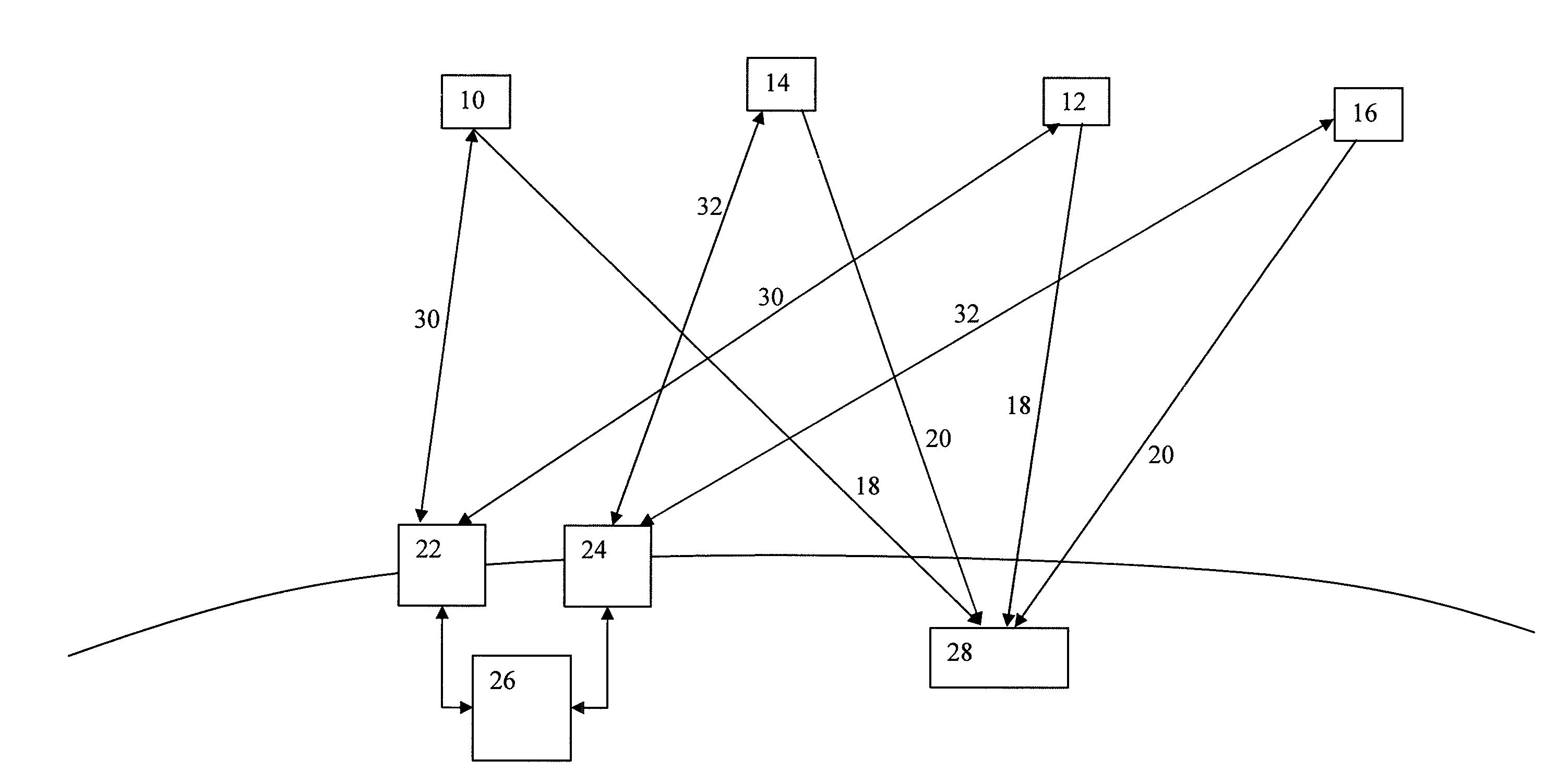
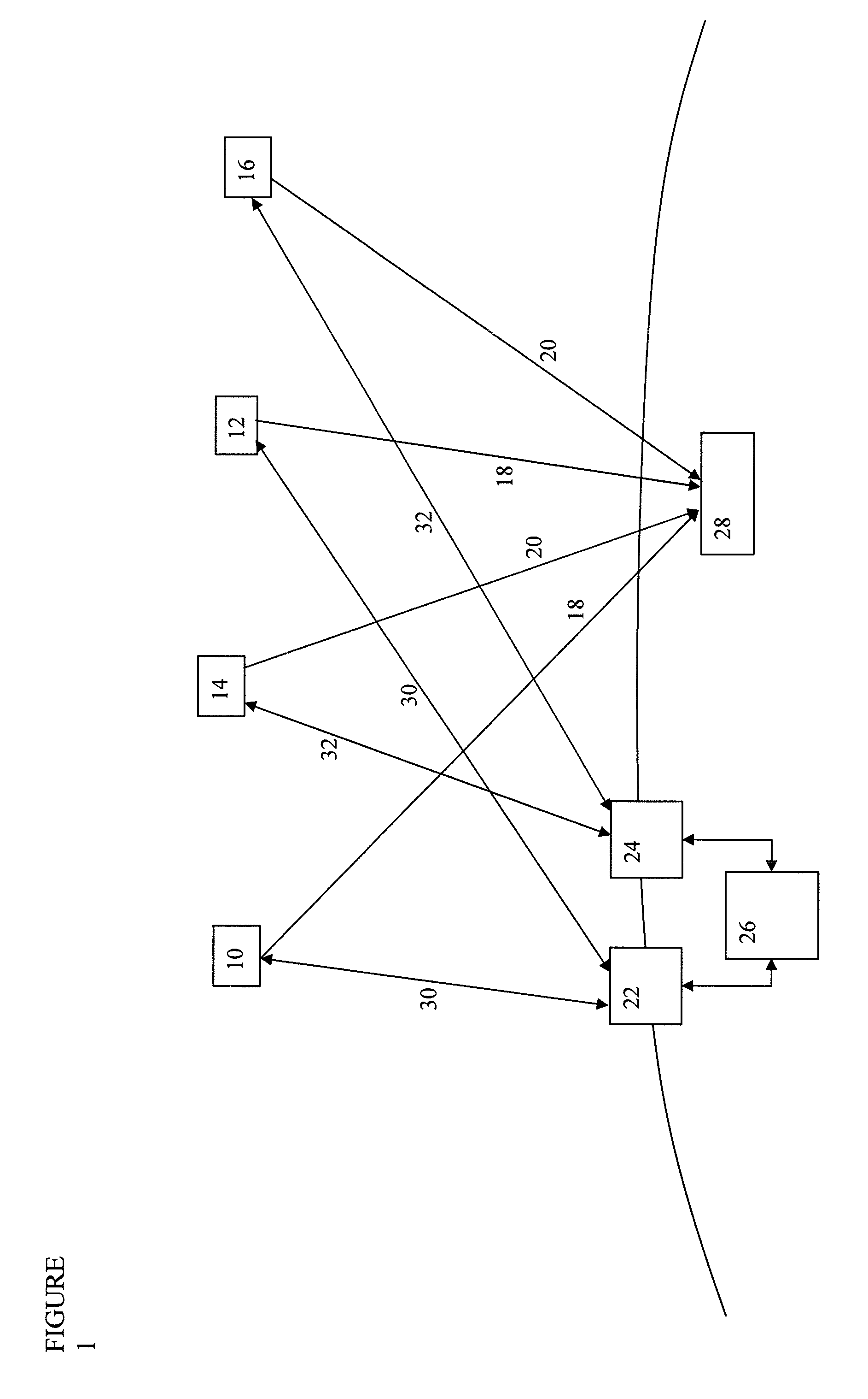
[0039]FIG. 1 shows a constellation with several satellites 10...


PUM


Abstract

Method, arrangement and system for improving a combined use of a plurality of different satellite navigation systems, in which each of the plurality of different satellite navigation systems includes a constellation of at least one satellite. The method includes broadcasting from each satellite of the constellation of a first satellite navigation system the clock models for all satellites of the constellation of a second satellite navigation system.

Description

CROSS-REFERENCE TO RELATED APPLICATIONS[0001]The present application claims priority under 35 U.S.C. §119 of German Patent Application No. 10 2011 106 589.3, filed on Jun. 16, 1011, the disclosure of which is expressly incorporated by reference herein in its entirety.BACKGROUND OF THE INVENTION[0002]1. Field of the Invention[0003]The invention relates to a method and an arrangement for improving the combined use of different satellite navigation systems and a receiver system for a combined use of different satellite navigation systems.[0004]2. Discussion of Background Information[0005]By the combined use of two different satellite navigation systems the precision, visibility and availability can be considerably improved. However, different satellite navigation systems normally use different representations of the international atomic time scale TAI (Temps Atomique International), whereby the system times of different satellite navigation systems generally differ. For example, NAVSTA...

Claims


Application Information

Patent Timeline
IPC IPC(8): G01S19/33G01S19/05
CPCG01S19/33G01S19/02G01S19/07G01S19/256G01S19/258
Inventor TRAUTENBERG, HANS L.
Owner AIRBUS DEFENCE & SPACE
Learn More