Navigation Redirect Using CMAS Emergency Alerts

a technology of navigation redirect and emergency alert, applied in navigation instruments, navigation systems, instruments, etc., can solve problems such as dangerous driving situations

Inactive Publication Date: 2014-01-30
TELECOMM SYST INC
View PDF12 Cites 44 Cited by
  • Summary
  • Abstract
  • Description
  • Claims
  • Application Information

AI Technical Summary

Benefits of technology

[0012]FIG. 1 depicts a conventional process for g...

Problems solved by technology

Unfortunately, a conventional geotargeted alert does not include a visual representation of an alert area, which may be helpful to a user when, e.g., attempting to evacuate an alert area.
Unfortunately, weather-related text alerts are broadcast to subscriber devices based on a set of pre-registered zip code values, as opposed to a device's curre...

Method used


Image

  • Navigation Redirect Using CMAS Emergency Alerts
  • Navigation Redirect Using CMAS Emergency Alerts
  • Navigation Redirect Using CMAS Emergency Alerts

Examples


Embodiment Construction

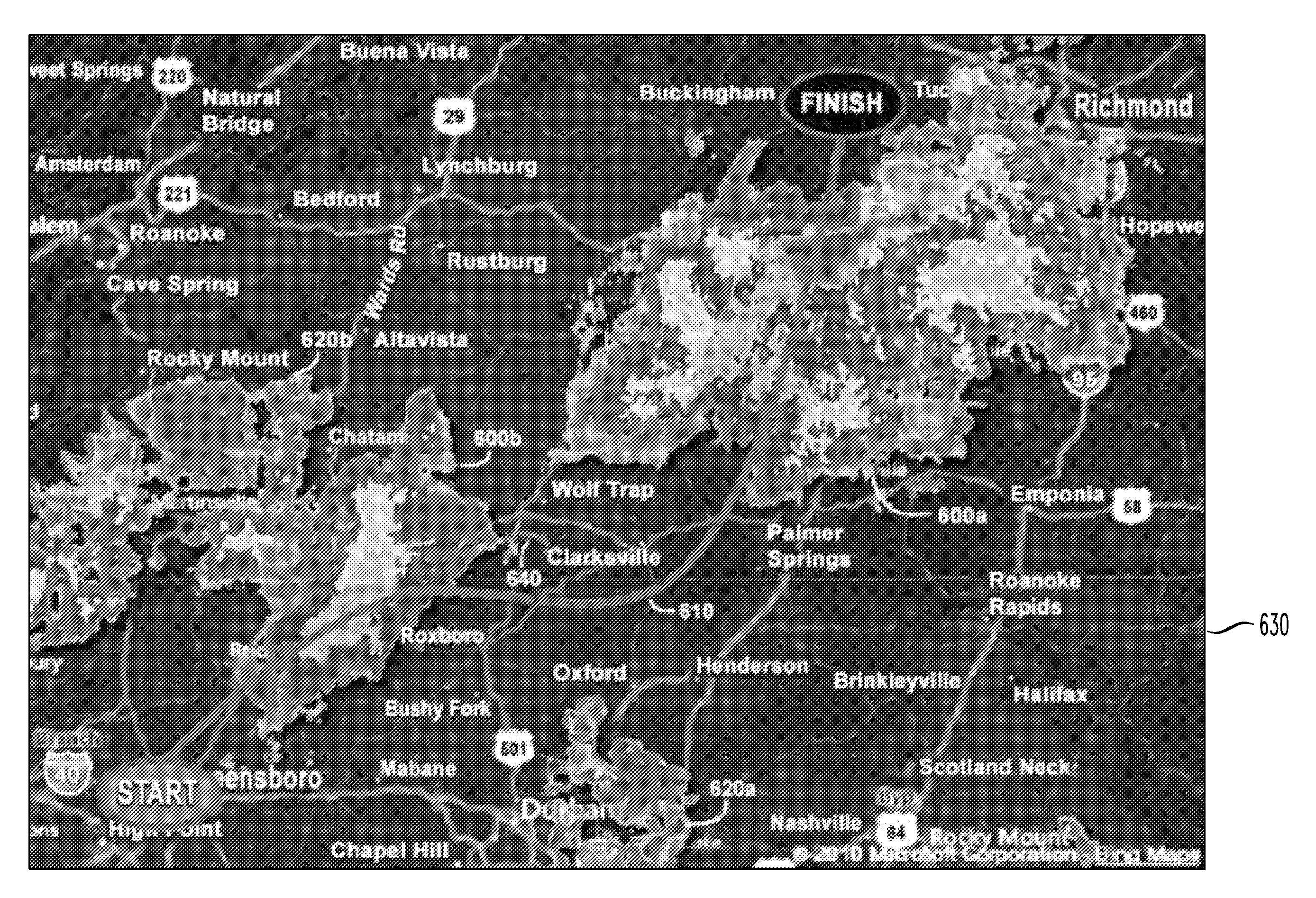
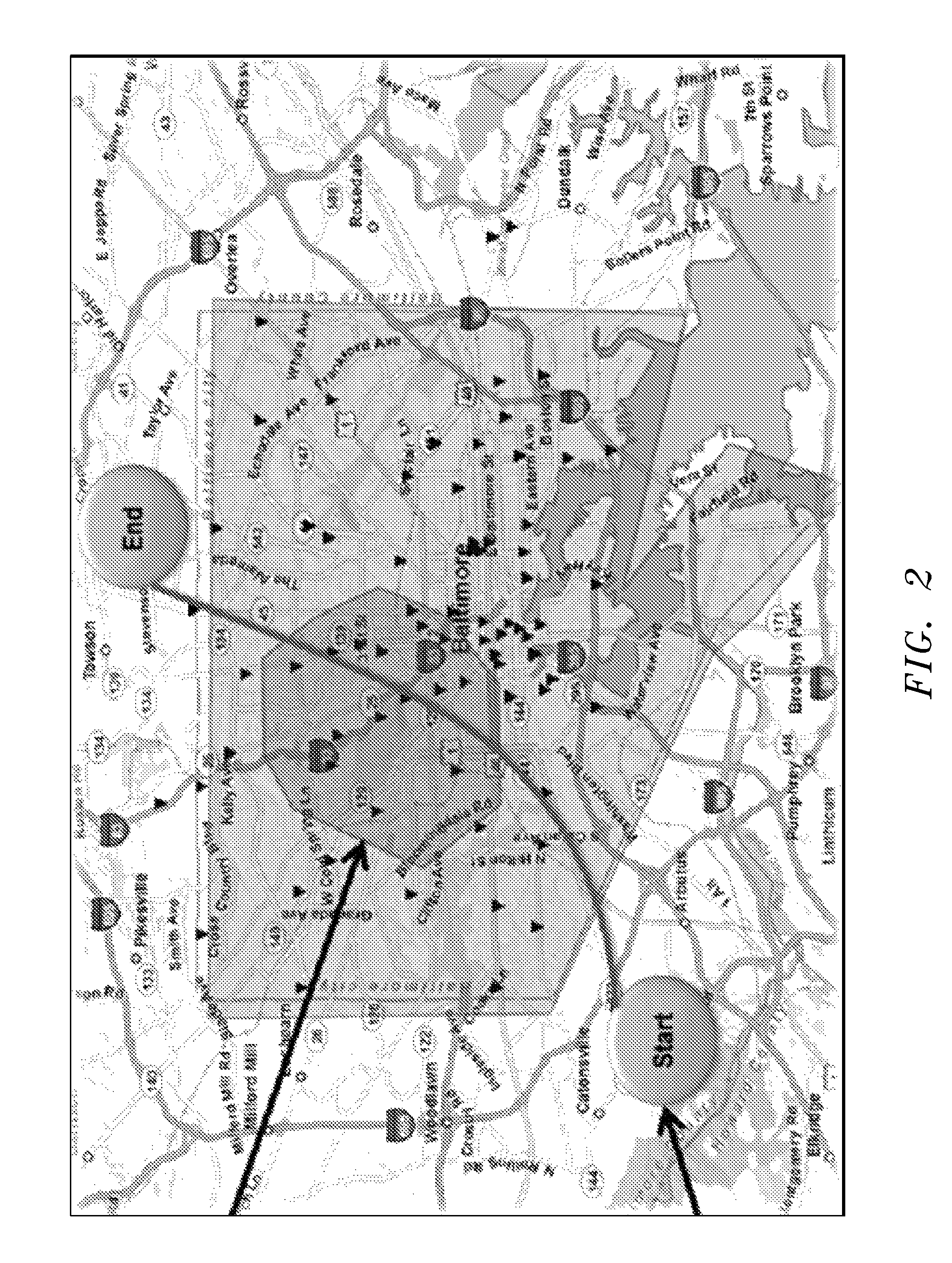
[0022]The present invention provides a navigation system integrated with knowledge of active emergency alert system (e.g. a commercial mobile alert system (CMAS)) alert data and up to date Doppler weather radar data, to provide a visual representation of active alert areas (i.e., areas of imminent threat to life and / or property) and / or current weather patterns on a map, and to automatically navigate a subscriber device away from any affected areas, e.g., active alert areas, areas under severe weather, etc.

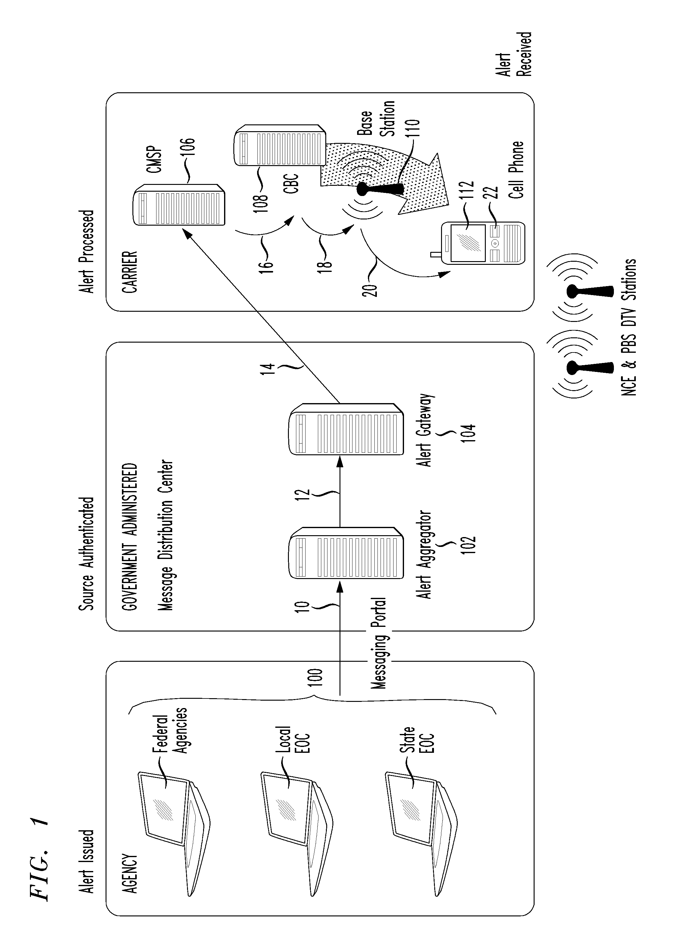
[0023]Conventional emergency alerting systems use cell broadcast technology to broadcast alert messages (similar to text messages) to subscriber devices located in geographically targeted areas. Geo-targeted alert messages alert subscribers to imminent threats to life and / or property occurring in or near their current location.

[0024]An alert area in a geotargeted alert is defined by a set of (X,Y) coordinates containing latitude and longitude ordered pairs that construct a polygon....


PUM


Abstract

A navigation system integrated with knowledge of active emergency alerting system alert data and up to date Doppler weather radar data, to provide a visual representation of an alert area and/or current weather patterns on a map, and to automatically navigate a subscriber device away from an affected area, e.g., an alert area, an area under severe weather. The inventive navigation system displays NEXRAD Doppler weather radar data on a map by integrating a NEXRAD feed into the map and allowing a user to enable/disable the NEXRAD feed as a map overlay. The inventive navigation system also automatically routes or reroutes a subscriber device to avoid areas under severe weather. The navigation system is also integrated with a conventional CMSP gateway in an emergency alerting system to provide: a visual representation of an alert area on a map and to automatically route/reroute a subscriber device around an alert area.

Description

[0001]The present invention claims priority from U.S. Provisional No. 61 / 677,094, filed Jul. 30, 2012, entitled “Navigation Redirect Using CMAS Emergency Alerts”, and from U.S. Provisional No. 61 / 678,743, filed Aug. 2, 2012, entitled “Utilize Information from Emergency Mass Notification Service for Routing Alert”, and from U.S. Provisional No. 61 / 678,747, filed Aug. 2, 2012, entitled “Overlay NEXRAD Data on Map View and Navigation View Screens”, and from U.S. Provisional No. 61 / 725,776, filed Nov. 13, 2012, entitled “Utilizing CMAS Emergency Alerts and Doppler Weather for MAP Display and Navigation Redirect”, the entirety of all of which are expressly incorporated herein by reference.BACKGROUND OF THE INVENTION[0002]1. Field of the Invention[0003]This invention relates generally to elements of using both CMAS notifications and Doppler weather radar for location, navigation, mapping, and mobile alerts.[0004]2. Background of Related Art[0005]On Jun. 28, 2012, a Commercial Mobile Alert...

Claims


Application Information

Patent Timeline
IPC IPC(8): G01C21/34
CPCG01C21/3453G01C21/3694
Inventor TITUS, MARK A.UNG, DARAWHITEHURST, THERESAWHITEHURST, JAYKLAHN, AUSTINCLARK, BRANT
Owner TELECOMM SYST INC
Why Eureka
Try Eureka