Automated Overpass Extraction from Aerial Imagery

an aerial imagery and automatic extraction technology, applied in the field of automatic extraction of aerial imagery, can solve the problems of distorted composite image, inability to show features in the correct locations of composite images, and inability to accurately represent scale in composite images created by stitching together many images of the ground

Inactive Publication Date: 2014-12-11
GOOGLE LLC
View PDF1 Cites 26 Cited by
  • Summary
  • Abstract
  • Description
  • Claims
  • Application Information

AI Technical Summary

Problems solved by technology

Aerial photos and satellite images, however, do not generally show features in their correct locations due to distortions caused by the tilt of the camera and / or the non-uniform terrain of the earth's surface.
In other words, when a large collection of aerial photographs or satellite images are stitched together to create a map, the resulting composite image is distorted.
Thus, in general, a composite image created by stitching together many images of the ground does not represent scale appropriately.
The scale of the composite image is, in general not constant, and accurate measurements of distance and direction cannot be made.
As mentioned above, aerial photographs are useful for providing spatial information, but they often contain geometric distortions.
One problem with the conventional orthorectification process is that it does not properly take into account objects such as buildings, bridges, trees, etc.

Method used


Image

  • Automated Overpass Extraction from Aerial Imagery
  • Automated Overpass Extraction from Aerial Imagery
  • Automated Overpass Extraction from Aerial Imagery

Examples


Embodiment Construction

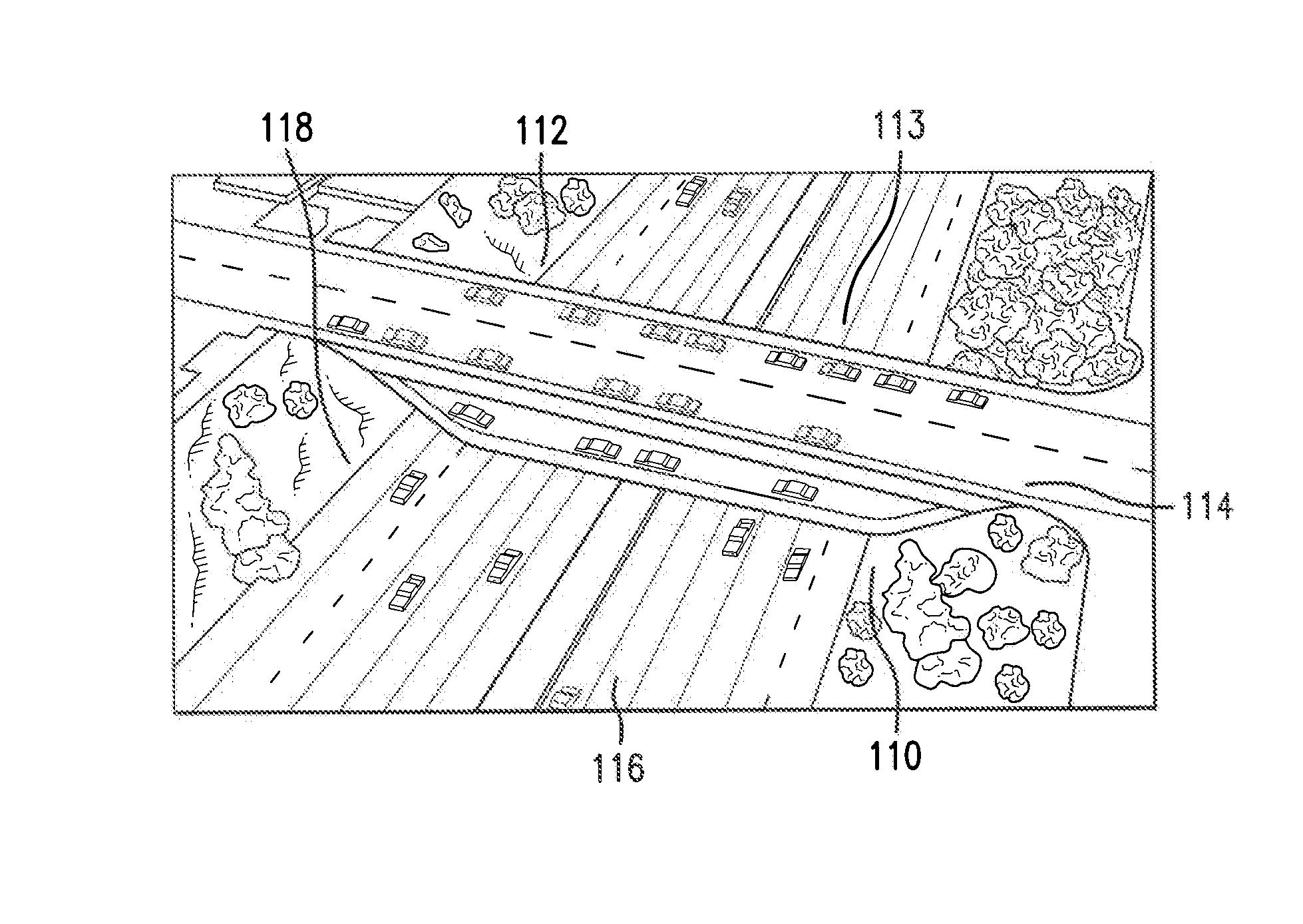
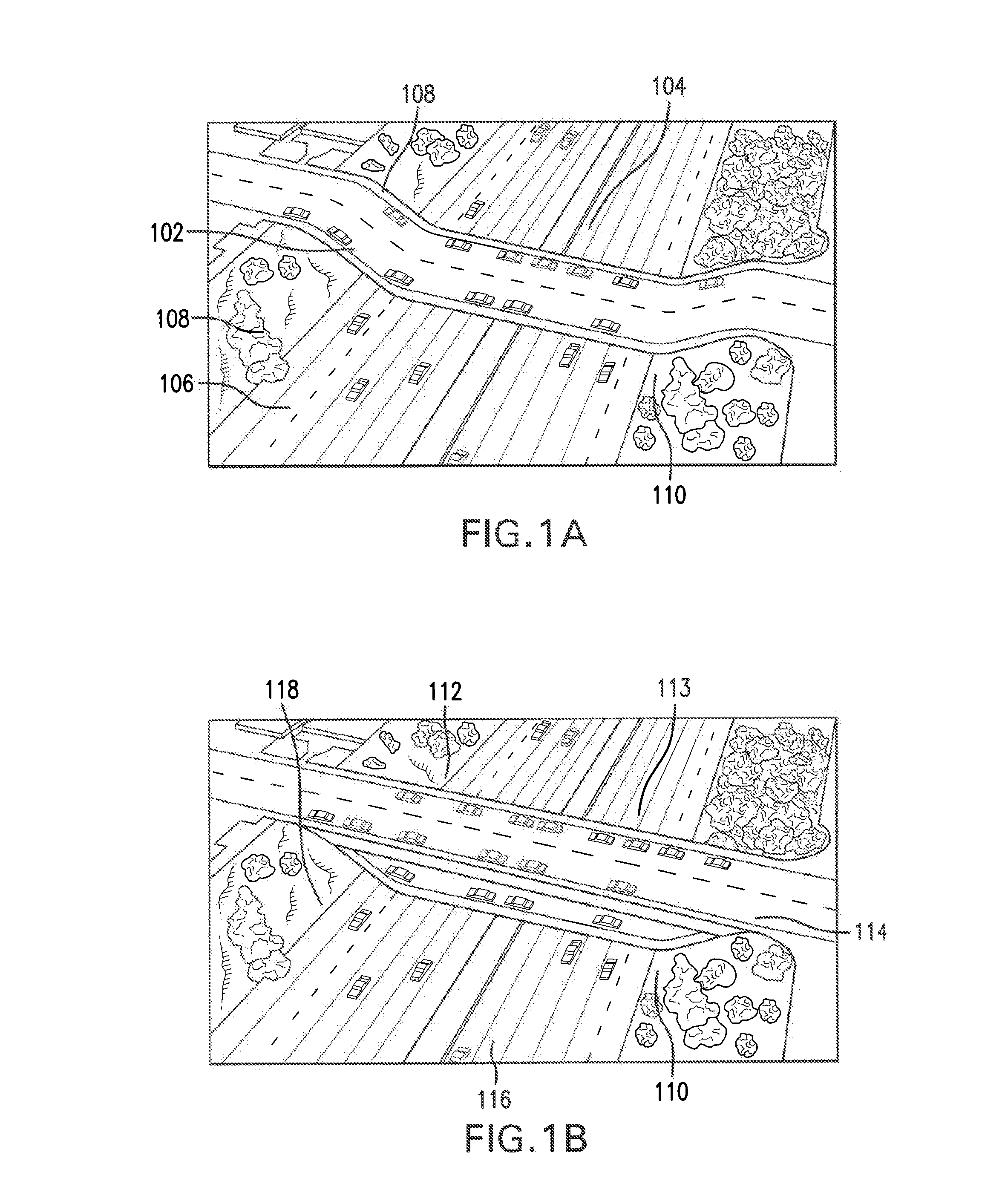
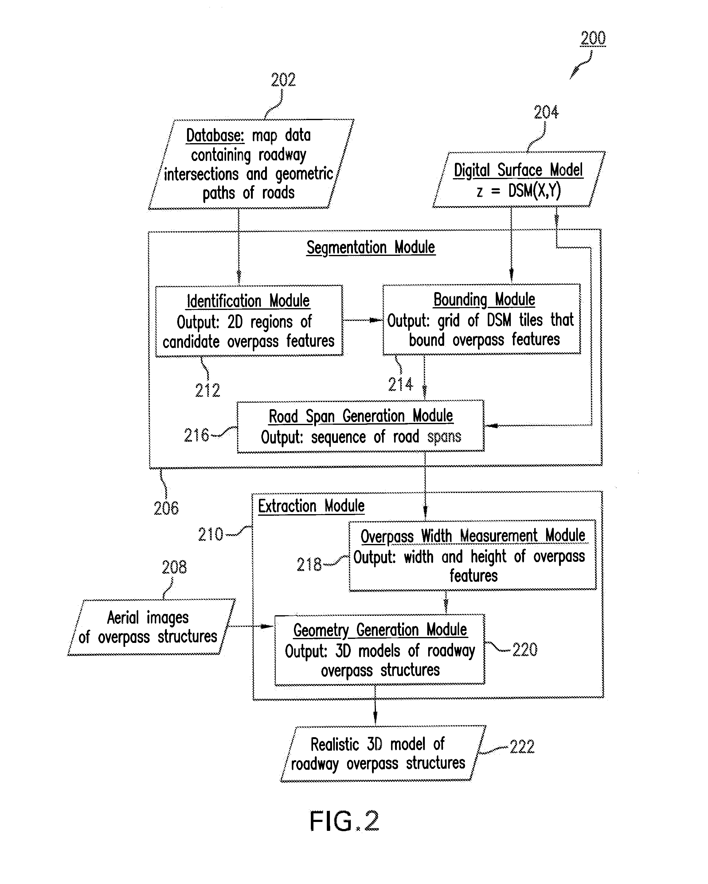
[0022]This disclosure is directed to systems and methods for generating realistic three-dimensional models of roadway overpass structures by combining aerial images with a DSM. It is noted that reference in the specification to “one embodiment,”“an embodiment,”“an example embodiment,” etc., indicate that the embodiment described may include a particular feature, structure or characteristic, but not every embodiment may necessarily include the particular feature, structure or characteristic. Moreover, such phrases are not necessarily referring to the same embodiment. Further, when a particular feature, structure or characteristic is described in connection with an embodiment, it is submitted that it is within the knowledge of one skilled in the art to effect such structure, feature or characteristic in connection with other embodiments, whether or not explicitly described. Embodiments will be described with reference to the accompanying figures.

[0023]This disclosure is concerned with...


PUM


Abstract

A computer implemented system and method is disclosed for generating realistic three-dimensional models of roadway overpass structures. An example system comprises a segmentation module configured to identify roadway overpass regions, based on existing map data containing locations of roadway intersections, aerial imagery, and a digital surface model (DSM). A roadway overpass region is assumed to have at least a first and second road segment. A DSM provides an elevation z for each two-dimensional point (x, y). The segmentation module identifies the upper and lower roadway sections of an overpass structure and an extraction module generates a three-dimensional model of the overpass based on the segmented regions identified by the segmentation module. The extraction module combines aerial images with 3D computer models of overpass structures to generate a realistic 3D rendering of surface topography of the earth including roadway overpass structures.

Description

BACKGROUND[0001]1. Field[0002]This disclosure relates to systems and methods for combining satellite and aerial imagery with map data and digital surface models for realistic 3D computer simulations and rendering of the topography of the earth's surface including local surface features.[0003]2. Background Art[0004]The field of aerial imagery is concerned with capturing photographs of land masses over large areas. In aerial imagery, one distinguishes between nadir images and oblique images. Nadir=images are photographed using a camera that faces straight down whereas oblique images are generated using cameras that are oriented at an angle to the ground. Aerial photographs are often combined. For example, a panoramic image can be made by stitching several photographs together. Large sets of aerial or satellite photographs can be combined and used in online map systems.[0005]Aerial photos and satellite images, however, do not generally show features in their correct locations due to di...

Claims


Application Information

Patent Timeline
Patent Type & Authority Applications(United States)
IPC IPC(8): G06T15/20
CPCG06T17/05
Inventor SCHPOK, JOSHUAREINHARDT, TILMAN
Owner GOOGLE LLC
Why Eureka
Try Eureka