Systems and methods for generating and employing an index associating geographic locations with geographic objects

Inactive Publication Date: 2014-12-18
GOOGLE LLC
View PDF3 Cites 10 Cited by
  • Summary
  • Abstract
  • Description
  • Claims
  • Application Information

AI Technical Summary

Benefits of technology

[0006]Various embodiments of methods and apparatus for identifying geographic objects near a given geographic location are provided herein. In some embodiments, provided is a computer-implemented method that includes for each geographic object of a geo-object set, identifying, using a computer, one or more geographic cells of a geographic mapping that each correspond to a geographic area proximate to at least a portion of a geometry of the geographic object and assigning a weighting value to each of the one or more geographic cells identified as corresponding to a geographic area proximate to at least a portion of a geometry of the geographic object such that the one or more geographic cells are associated with the geo-object. The method also including, for each geographic cell assigned one or more weighting values, aggregating the one or more weighting values assigned to the geographic cell to generate an aggregated weighting value for the geographic cell, identifying a set of dense geographic cells (each geographic cell of the set of dense geographic cells having an aggregated weighting value that satisfies a weighting threshold criteria) and generating an index associating each of the one or more geographic cells of the set of dense geographic cells with one or more geographic objects associated with the geographic cell.
[0007]In some embodiments, provided is a non-transitory computer readable storage medium having computer-executable program instructions stored thereon that are executable by a computer to cause steps including identifying, using a computer, one or more geographic cells of a geographic mapping that each correspond to a geographic area proximate to at least a portion of a geometry of the geographic object and assigning a weighting value to each of the one or more geographic cells identified as corresponding to a geographic area proximate to at least a portion of a geometry of the geographic object such that the one or more geographic cells are associated with the geo-object. The steps also including, for each geographic cell assigned one or more weighting values, aggregating the one or more weighting values assigned to the geographic cell to generate an aggregated weighting value for the geographic cell, identifying a set of dense geographic cells (each geographic cell of the set of dense geographic cells having an aggregated weighting value that satisfies a weighting threshold criteria) and generating an index associating each of the one or more geographic cells of the set of dense geographic cells with one or more geographic objects associated with the geographic cell.
[0008]In some embodiments, provided is a system including a processor, a memory and a location module stored on the memory. The location module is configured to be executed by the

Problems solved by technology

Unfortunately, these techniques may require a large amount of processing to generate the search results.
For example, where a database contains an extremely large number of points of interest, determining the distance between the query point and each of the points of the database may require a

Method used


Image

  • Systems and methods for generating and employing an index associating geographic locations with geographic objects
  • Systems and methods for generating and employing an index associating geographic locations with geographic objects
  • Systems and methods for generating and employing an index associating geographic locations with geographic objects

Examples


Embodiment Construction

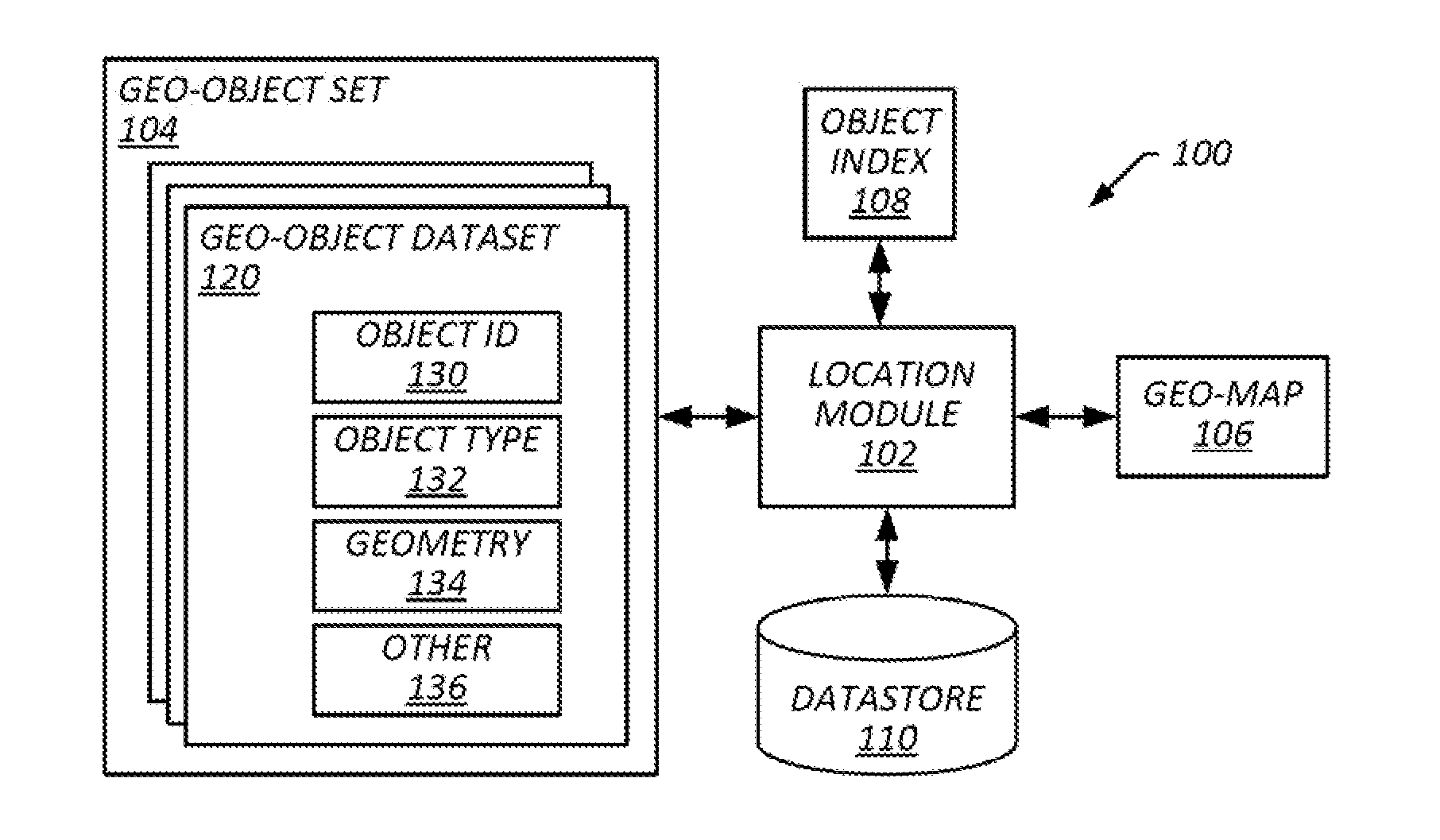
[0028]As discussed in more detail below, provided in some embodiments are systems and methods for processing and responding to nearest-neighbor queries. In some embodiments, an index is generated that associates cells of a geographic mapping (“geo-mapping”) to geo-graphic objects (“geo-objects”) that are located in and / or proximate the cell (e.g., within a given radius). In certain embodiments, upon receiving a nearest-neighbor query specifying a given geographic location (e.g., geolocation), a cell of the geo-mapping containing the geographic location is identified, and the index is accessed to identify geo-objects corresponding to the cell. In some embodiments, the geo-objects corresponding to the cell are processed to identify one or more of the geo-objects that are closest to the geolocation.

[0029]In some embodiments, an index is generated via processing of each geo-object of a geo-object set corresponding to the geo-mapping. In certain embodiments, each of the geo-objects are p...


PUM


Abstract

A computer-implemented method that includes for each geographic object of a geo-object set, identifying, using a computer, one or more geographic cells of a geographic mapping that each correspond to a geographic area proximate to at least a portion of a geometry of the geographic object and assigning a weighting value to each of the one or more geographic cells identified as corresponding to a geographic area proximate to at least a portion of a geometry of the geographic object such that the one or more geographic cells are associated with the geo-object. The method also including, for each geographic cell assigned one or more weighting values, aggregating the one or more weighting values assigned to the geographic cell to generate an aggregated weighting value for the geographic cell, identifying a set of dense geographic cells (each geographic cell of the set of dense geographic cells having an aggregated weighting value that satisfies a weighting threshold criteria) and generating an index associating each of the one or more geographic cells of the set of dense geographic cells with one or more geographic objects associated with the geographic cell.

Description

BACKGROUND OF THE INVENTION[0001]1. Field of the Invention[0002]This invention relates generally to identifying nearest-neighbors and more particularly to identifying geographic objects near a geographic location.[0003]2. Description of the Related Art[0004]Nearest-neighbor searches are often employed to find points that are close to one another in a given space. In the context of geographic mappings, a nearest-neighbor search may be employed to identify geographic objects that are closest to a given location. For example, where a user submits a request to locate a gas station nearest to their location, a database of any number of points of interest may be searched to identify the gas-station closest to the user's current location.[0005]Various techniques have been employed in the past to execute nearest-neighbor searches. For example, in a linear approach, a distance is computed from the query point (e.g., the user's location) to every other point in the database (e.g., the locatio...

Claims


Application Information

Patent Timeline
IPC IPC(8): H04W4/02
CPCH04W4/021G06F16/29
Inventor CAILLETTE, FABRICEANDREICA, MUGUREL IONUTSTROE, DIANAMALESINSKI, TOMASZ
Owner GOOGLE LLC
Why Eureka
Try Eureka