Systems and methods for initiating mapping exit routines and rating highway exits

a mapping and highway technology, applied in the field of system and method for initiating mapping exit routines and rating highway exits, can solve the problems that conventional mapping applications or services do not provide a way to identify such situations or assist users

Active Publication Date: 2015-04-16
VERIZON PATENT & LICENSING INC
View PDF2 Cites 37 Cited by
  • Summary
  • Abstract
  • Description
  • Claims
  • Application Information

AI Technical Summary

Problems solved by technology

For example, during a road trip, a user might intentionally take a highway off-ramp for a rest stop or other reason and be frustrated by a mapping service continually recommending that the user get right back on the highway.
However, conventional mapping applications or services do not provide a way to identify such situations or assist the user by, for example, providing the user with helpful information related to possible points of interest that may be located near the user's current location, i.e., at the exit.

Method used


Image

  • Systems and methods for initiating mapping exit routines and rating highway exits
  • Systems and methods for initiating mapping exit routines and rating highway exits
  • Systems and methods for initiating mapping exit routines and rating highway exits

Examples


Embodiment Construction

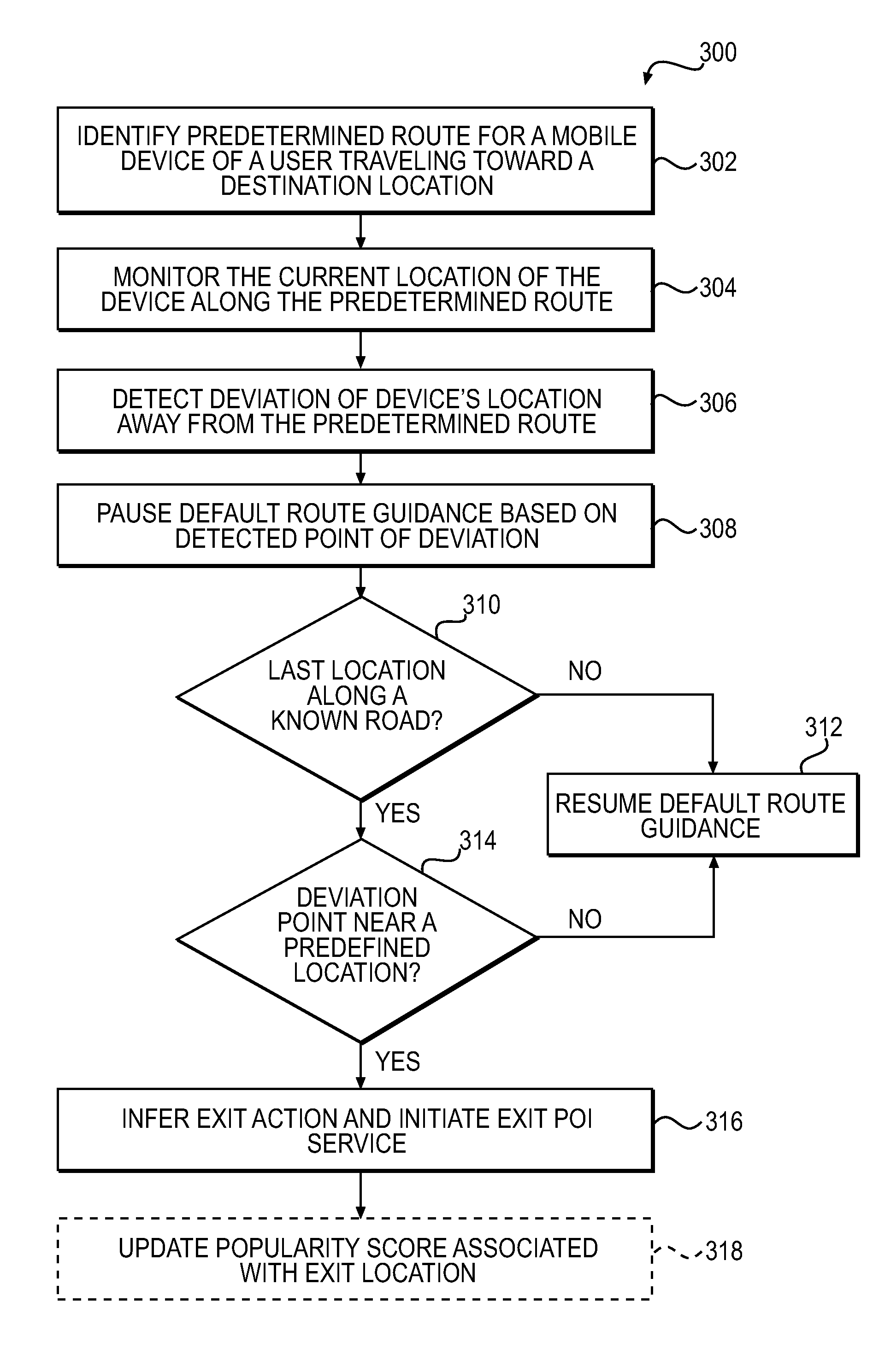
[0017]The present disclosure is directed to overcoming one or more of the above referenced issues. Specifically, the present disclosure is directed to systems and methods for inferring a mobile device user's intent to stop along a predetermined or prescribed route of travel in order to use amenities or points of interest (POIs) located along the predetermined route. Upon detecting that the user has deviated away from the predetermined route, an application executable at a user's mobile device may automatically infer or query the user's intent to stop at any of the nearby POIs.

[0018]In an example, the predetermined route may be based on, for example, directions generated by a navigation or route planning feature of a mapping application or service executable at the user's mobile device. A portion of the predetermined route of travel may be along, for example, a highway and the detected point of deviation may be, for example, an exit location or off-ramp along the highway. Further, th...


PUM


Abstract

Systems and methods are provided for inferring a user's intent to stop at a predefined location or breakpoint along a predetermined route, such as an exit along a highway, and to enable users to report back to systems maintaining exit or breakpoint POI data. An application executing on a user's mobile device may infer or query the user's intent upon detecting a deviation away from the route and to use this as a “check-in” at a predefined location corresponding to the point of deviation. Then further check-ins and ratings at amenities / locations associated with the exit can also be used to enhance the rating and popularity of the predefined location (e.g., highway exit) itself. The ratings and popularity of highway exits can then be exposed in applications to provide relevant content related to the highest rated or most popular breakpoints located along their route of travel.

Description

TECHNICAL FIELD[0001]The present disclosure relates generally to location based services for mobile devices, and more particularly, to providing mapping information and recommendations for points of interest to a user of a mobile device based on the geographic location of the user or the user's mobile device.BACKGROUND[0002]In recent years, the use of electronic maps and mapping applications has grown significantly. Such mapping applications may be executable at various types of user devices. Examples of such devices include, but are not limited to, an onboard navigation system in a vehicle, a dedicated portable Global Positioning System (GPS) device, or other type of mobile computing device, e.g., a smartphone. The displayed electronic maps often convey information related to roads, traffic, buildings, landmarks, terrain, and other geographic locations or regions of interest. Some electronic maps may be interactive, allowing users to view, for example, a digital map of a particular...

Claims


Application Information

Patent Timeline
Patent Type & Authority Applications(United States)
IPC IPC(8): G01C21/34G01C21/36
CPCG01C21/3476G01C21/3484G01C21/3679G01C21/3415G06N7/01G06N5/04
Inventor NESBITT, DAVID W.
Owner VERIZON PATENT & LICENSING INC
Why Eureka
Try Eureka