Method and system for an emergency location information service (e-lis) from automated vehicles

a technology of location information and automated vehicles, applied in the direction of wireless commuication services, machine-to-machine/machine-type communication services, instruments, etc., can solve the problems of inability to meet the requirements accuracy, prior art methods of accomplishing such locations, etc., to achieve the effect of rapid location determination, automation, and accuracy, and navigation using conventional maps and visual observation or dead reckoning is not readily automated

Active Publication Date: 2015-11-19
EVERBRIDGE
View PDF5 Cites 201 Cited by
  • Summary
  • Abstract
  • Description
  • Claims
  • Application Information

AI Technical Summary

Problems solved by technology

For example, in the event of a vehicular accident, public safety personnel may need to operate within an unfamiliar wooded area on short notice, in conditions of poor visibility due to smoke, flame or darkness.
A mobile device an individual may be carrying may not be able to communicate because of poor signal strength to the mobile device in the rural area.
Prior art methods of accomplishing such location do not simultaneously meet the requirements of rapid location determination, automation, and accuracy.
Navigation employing conventional maps and visual observation or dead reckoning are not readily automated and thus require time and attention by a human observer.
There are many problems associated with determining a location of a network device and a caller who needs to place an E911 call or a person who sends a text to E911 in an emergency situation.
One problem is the network device and caller may be located in a remote area, rural area in the event of a natural disaster or terrorist attack when a local infrastructure may be compromised or an adequate communication signal not available to send an emergency message.
Another problem is that many E911 calls a misrouted to the wrong PSAP.
This can delay the dispatch of emergencies services to the caller.
Another problem is that existing mobile technology makes its difficult to accurately locate mobile devices.
Another problem is that triangulation based on time of arrival at multiple mobile-communications base stations (TDOA) has inadequate coverage and is insufficiently accurate unless supplemented by signals provided by local radios placed outside the facility by public safety personnel.
Another problem is that conventional radio-frequency-based location methods do a poor job of providing topological location within a building: that is, location relative to floors, walls, doors, partitions, stairways, and other features whose spatial extent is small but whose significance to a person's ability to move is great.
Another problem is that many wearable mobile devices are not “location-aware.” Location-aware devices are aware of their current geographic location.
However, mobile telephones may only determine their current geographic location by communicating with a particular mobile phone interface or telephony switch that provides coverage to a geographic location such as a telephony “cell” but not an exact current geographic location within the cell.
Another problem is that it mobile devices are being allowed to send Short Message Services (SMS) text-to-911 messages to contact emergency services when an emergency occurs.
Another problem is that many people are using automated vehicles such as those provided by GOOGLE and others.
In many instances, the occupant of the automated vehicle has a disability (e.g., is blind, paralyzed, etc.) or a medical problem (e.g., vision problem, speech problem, etc.) and is not capable of communicating with emergency personal after an accident or during an emergency situation (e.g., terrorist event, etc.).

Method used


Image

  • Method and system for an emergency location information service (e-lis) from automated vehicles
  • Method and system for an emergency location information service (e-lis) from automated vehicles
  • Method and system for an emergency location information service (e-lis) from automated vehicles

Examples


examplery electronic emergency

Information Message Processing System

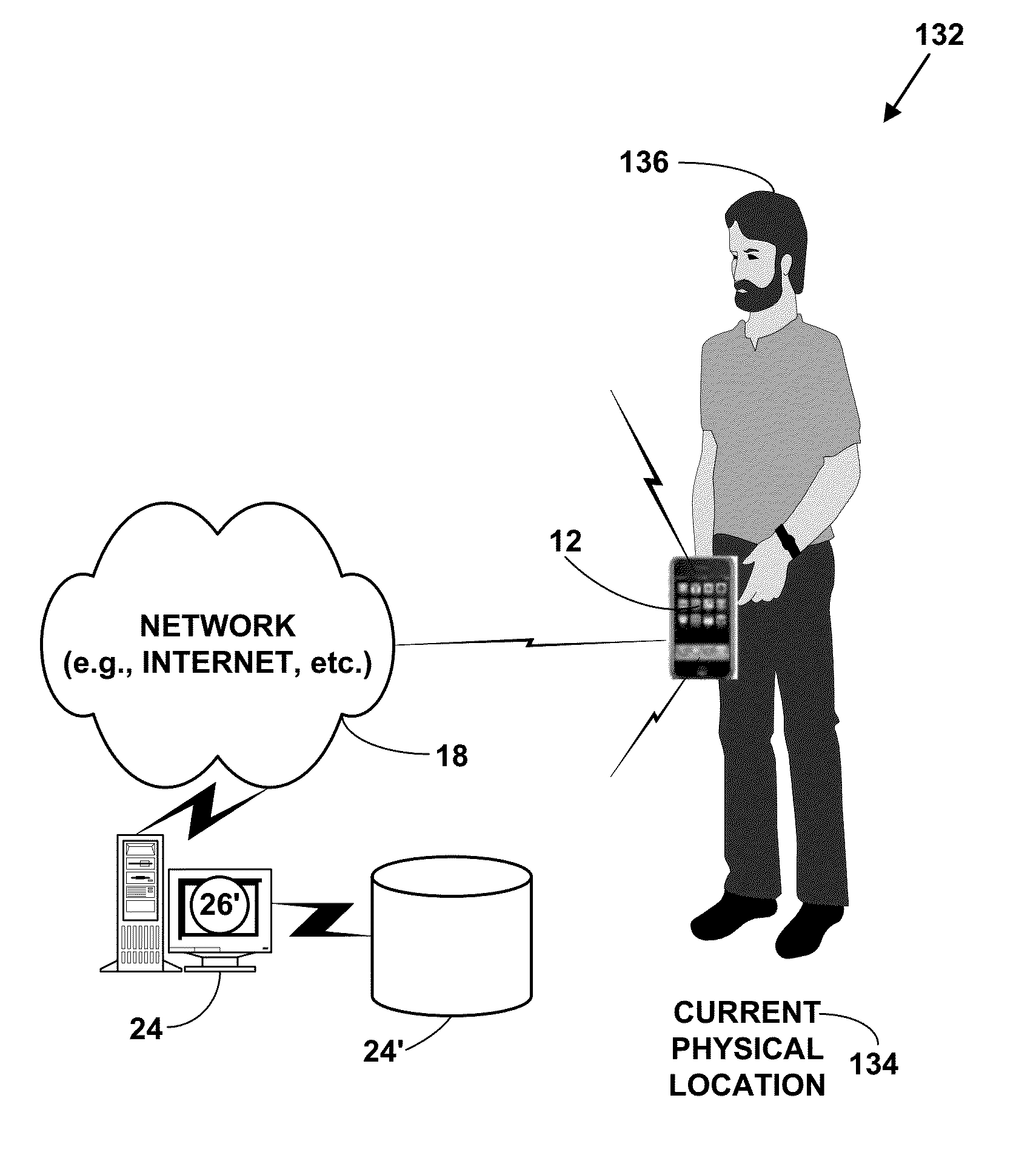
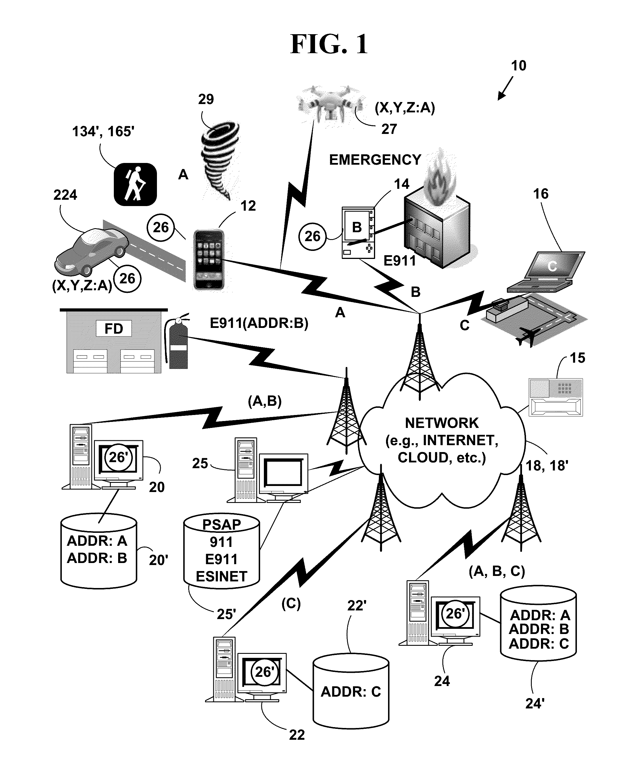
[0053]FIG. 1 is a block diagram illustrating an exemplary communications system 10. The exemplary communications system 10 includes, but is not limited to, one or more target network devices 12, 14, 16 (only three of which are illustrated) each with one or more processors. The target network devices 12, 14, 16 include, but are not limited to, wearable devices (e.g., glasses, watches, wrist bands, clothing, jewelry, etc.), mobile phones, non-mobile phones, smart phones, tablet computers, portable gaming platforms (GAMEBOY and DSI by Nintendo, PSP by Sony, etc.), non-portable gaming platforms (e.g., XBOX by Microsoft, Wii by Nintendo, PLAY STATION, by Sony, etc.) non-mobile computers, wireless devices, wired devices, game devices, laptop computers, personal information devices, personal digital / data assistants (PDA), hand-held devices, network appliances, Internet appliances, cable television set-top boxes, Internet television set-top boxes, satell...


PUM


Abstract

A method and system for determining and verifying a location of a network device of an automated vehicle (i.e., driverless, etc.) and/or an occupant of an automated vehicle in emergency situations from automated vehicles. The method and system provide a current physical geographic location for the automated vehicle or mobile devices of an occupant and/or of occupant of an automated vehicle in an emergency situation such as an accident, health, fire, terrorist attack, military incident, weather, flood event, etc. and forwarding the current physical geographic location to a legacy 911 network, a Emergency Services IP networks (ESInet) or text-to-911 Short Message Services (SMS) networks to alert emergency responders.

Description

CROSS REFERENCES TO RELATED APPLICATIONS[0001]This U.S. utility patent application is a Continuation-In-Part (CIP) of U.S. utility patent application Ser. No. 14 / 579,760, filed on Dec. 22, 2014, that issued as U.S. Pat. No. 9,094,816, on Jul. 28, 2015, which is a CIP of U.S. patent application Ser. No. 14 / 303,842, filed on Jun. 13, 2014, that issued as U.S. Pat. No. 8,918,075, on Dec. 23, 2014, which is a CIP of U.S. utility patent application Ser. No. 13 / 831,426, filed Mar. 14, 2013, which issued as U.S. Pat. No. 8,755,767, on Jun. 17, 2014, which is a CIP of U.S. utility patent application Ser. No. 13 / 098,981, filed May 2, 2011, which issued and U.S. Pat. No. 8,442,482 on May 14, 2013, which is a CIP of U.S. utility patent application Ser. No. 11 / 803,671, filed May 15, 2007, which issued as U.S. Pat. No. 7,937,067, on May 3, 2011, which is an application that claims priority to U.S. Provisional patent application Nos. 60 / 800,774, 60 / 800,775, 60 / 800,776, and 60 / 800,777, all filed M...

Claims


Application Information

Patent Timeline
Patent Type & Authority Applications(United States)
IPC IPC(8): H04W4/22H04M1/725H04W4/02H04M1/72421H04M1/72433H04W4/90
CPCH04W4/22H04M1/7255H04M1/72538H04W4/023H04W4/025H04W64/00G01S19/17G01S1/00G01S5/0027H04W4/70H04W4/90H04W76/50H04W4/80G01S2205/06H04M1/72421H04M1/72433H04W64/003
Inventor MAIER, NICHOLAS M.EISNER, GERALD R.
Owner EVERBRIDGE
Why Eureka
Try Eureka