Map marking method

a map and method technology, applied in the field of map marking methods, can solve the problems of huge difference, user often encounters the problem of not and user still has difficulties in knowing his exact position on the map

Inactive Publication Date: 2016-06-02
INVENTEC PUDONG TECH CORPOARTION +1
View PDF0 Cites 4 Cited by
  • Summary
  • Abstract
  • Description
  • Claims
  • Application Information

AI Technical Summary

Problems solved by technology

However, due to the size of the monitor and the scale of the navigation device, the user often encounters the problem of not knowing his exact position on the map.
Mountaineers need to determine the climbing path according to the conditions of the mountain and a tiny lapse can lead to a huge difference.
In addition, the built-in electronic map of the navigation device may not include the detailed information for mountain c

Method used


Image

  • Map marking method
  • Map marking method
  • Map marking method

Examples


Embodiment Construction

[0032]In the following detailed description, for purposes of explanation, numerous specific details are set forth in order to provide a thorough understanding of the disclosed embodiments. It will be apparent, however, that one or more embodiments may be practiced without these specific details. In other instances, well-known structures and devices are schematically shown in order to simplify the drawings.

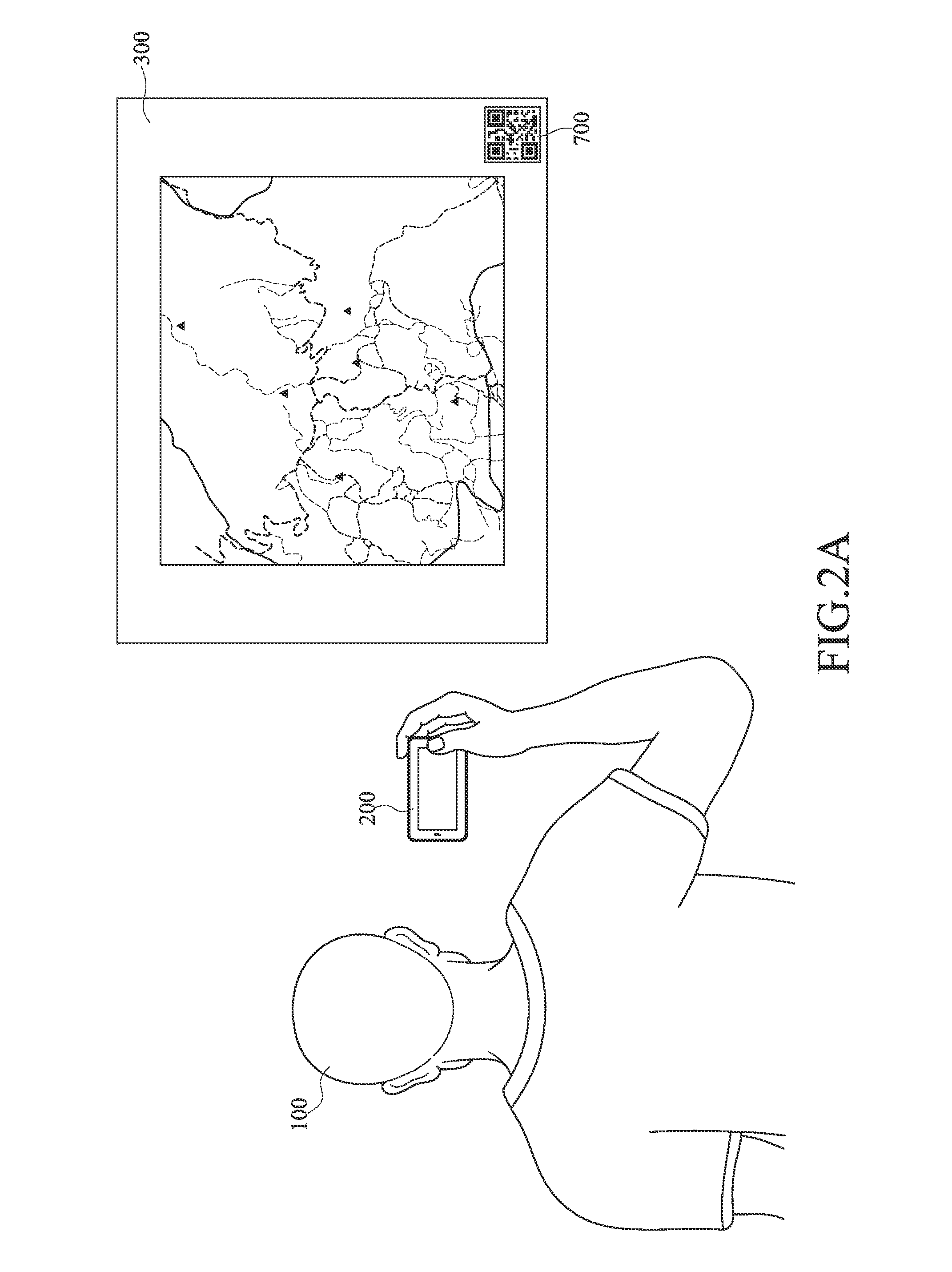
[0033]An embodiment of the present invention is adapted for a device with global positioning system (GPS). For example, the device is but not limited to a navigation device, a positioning device, or a portable device with the GPS function, which includes an image capturing device, a processor and a marking device, such as a smart phone, a tablet, a notebook, or any portable device with arithmetic functions. The embodiment is for illustrating but not for limiting the present disclosure.

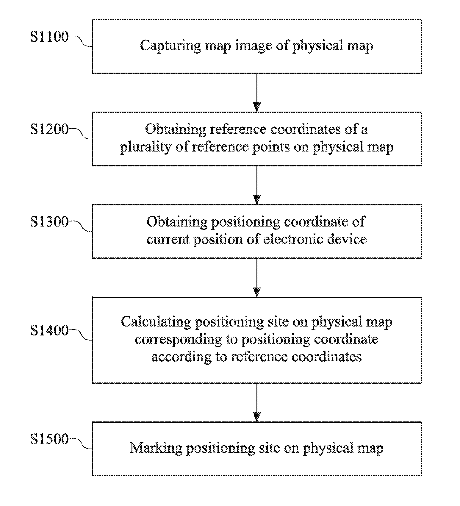
[0034]Please refer to FIG. 1. FIG. 1 is a flowchart of the method for marking on a map according t...


PUM


Abstract

A map marking method comprises capturing a map image from a physical map, capturing a plurality of reference coordinates corresponding to the physical map, obtaining a positioning coordinate from the global positioning system, calculating a positioning site on the physical map corresponding to the positioning coordinate according to the plurality of reference coordinates, the map image, and the positioning coordinate, and marking the positioning site on the physical map. As such, a user may arbitrarily mark his/her own position on a physical map with his/her positioning device utilizing the above mentioned method, and may explore the world more conveniently.

Description

CROSS-REFERENCE TO RELATED APPLICATIONS[0001]This non-provisional application claims priority under 35 U.S.C. §119(a) on Patent Application No. 201410697220.4 filed in China on Nov. 27, 2014, the entire contents of which are hereby incorporated by reference.BACKGROUND OF THE INVENTION[0002]1. Technical Field of the Invention[0003]The present invention relates to a method for marking a map, particularly to a method for marking a current position of a user on a physical map.[0004]2. Description of the Related Art[0005]A navigation device is an electronic device for the path navigation and / or the direct navigation by combining global positioning system (GPS) signals and an electronic map, wherein direct navigation only labels the direction and the distance of the destination. The navigation device also displays the current position of the user on the map. However, due to the size of the monitor and the scale of the navigation device, the user often encounters the problem of not knowing...

Claims


Application Information

Patent Timeline
IPC IPC(8): G01C21/00G06F17/30
CPCG06F17/30241G01C21/00G09B29/106G01C21/20
Inventor CHEN, LI-TE
Owner INVENTEC PUDONG TECH CORPOARTION
Why Eureka
Try Eureka