Systems and Methods for Satellite Image Processing to Estimate Crop Yield

a satellite image and crop yield technology, applied in the field of satellite image processing, can solve the problems of affecting different types of decisions in agriculture and other fields, unable to achieve, and the cost associated with getting images and processing images to obtain the desired information is prohibitiv

Active Publication Date: 2016-06-16
THE BOARD OF TRUSTEES OF THE LELAND STANFORD JUNIOR UNIV
View PDF7 Cites 42 Cited by
  • Summary
  • Abstract
  • Description
  • Claims
  • Application Information

AI Technical Summary

Benefits of technology

[0005]The above and other problems are solved and an advance in the art is made by systems and methods for generating a crop yield estimation using satellite image processing in accordance with some embodiments of this invention. In accordance with some embodiments of the invention, an image processing system generates a crop yield estimation for an area as small as a single field in the following manner. The image processing system receives images captured by a satellite. Each of the images includes pixels that correspond to an area and is captured on a particular date. Environmental information for the area on the date that each image was captured is obtained using the image processing system. The environmental information is of a same temporal scale as the environmental information used to generate a statistical model of a region including the area. Crop information for the area from the pixels in the images that correspond to the area is determined using the image processing system. The image processing system applies the statistical model of the region including the area to the environmental information obtained for the area on at least two different dates and the crop information for the area from the at least two different dates determined from the images to determine a crop yield estimate. The statistical model has a plurality of variables including at least one variable from the crop information and at least one variable from the environmental information. The crop yield estimate is provided to an application by the image processing system for use in showing a predicted crop yield for the area.

Problems solved by technology

Lack of reliable information on crop yields can hinder different types of decisions in agriculture and other fields.
Although some have tried to estimate crop for an area the size of an individual field, they have been unsuccessful in doing so.
Besides lack of accuracy, other problems with using satellite imagery to estimate crop yield for an area the size of an individual field include the cost associated with getting the images and processing the images to obtain the desired information has been prohibitive and the lack of data of the actual yields of specific areas are often hard to obtain as records.

Method used


Image

  • Systems and Methods for Satellite Image Processing to Estimate Crop Yield
  • Systems and Methods for Satellite Image Processing to Estimate Crop Yield
  • Systems and Methods for Satellite Image Processing to Estimate Crop Yield

Examples


Embodiment Construction

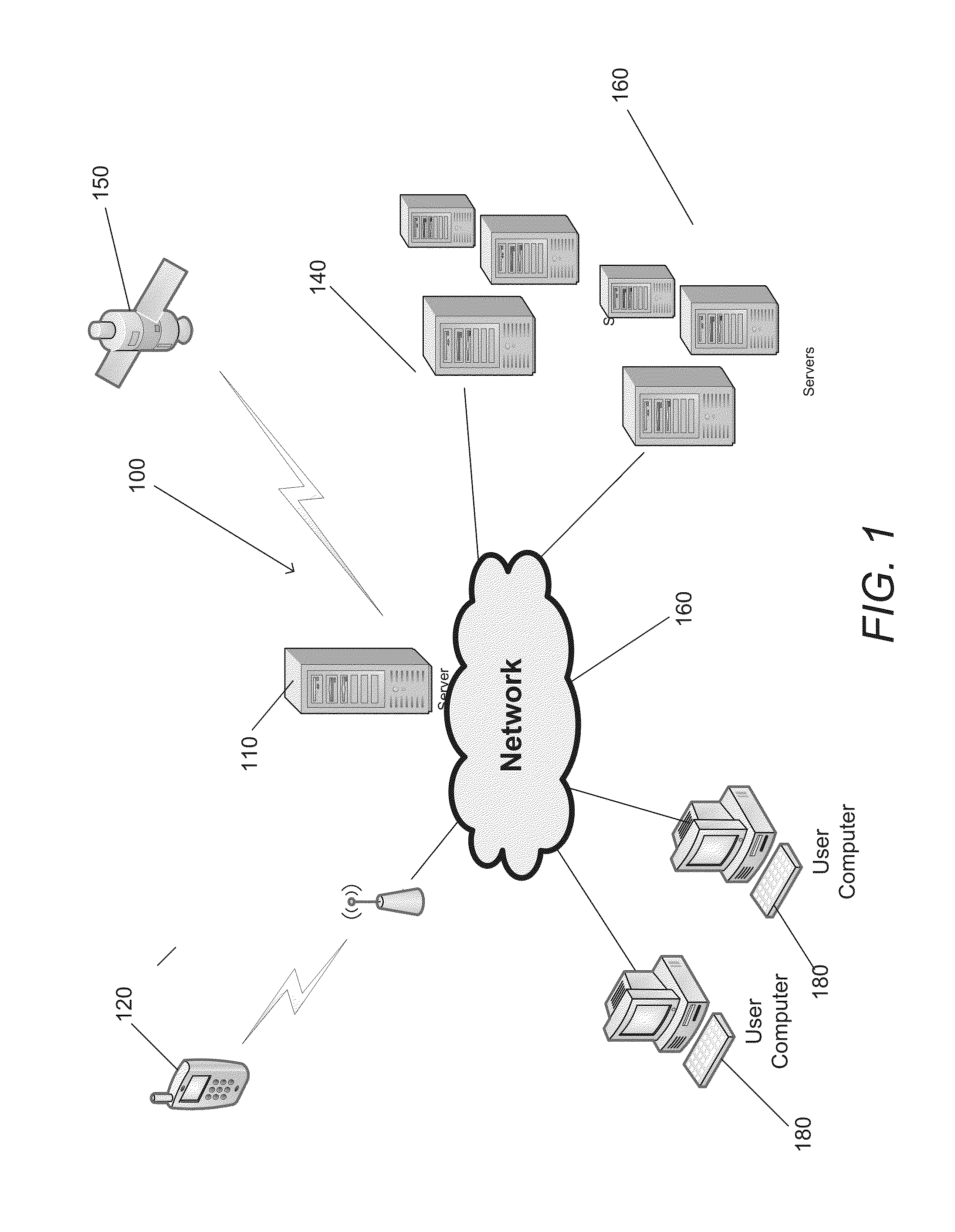
[0022]Turning now to the drawings, systems and methods for processing satellite images to determine crop yield estimations for an area as small as an individual field using images captured by a satellite in accordance with various embodiments of the invention are disclosed. In accordance with some embodiments of the invention, a statistical model that has two or more variables is used to determine a crop yield estimate of an area the size of an individual field. For purposes of this discussion, an individual field is an individual farm and / or individual field that is a smaller portion of an individual farm that is observable in an image captured by a satellite that may be represented by a portion of the pixels in an image. In accordance with many embodiments that area may be the area represented by a single pixel in the image. In a number of embodiments, crop yield estimates can be generated at a resolution of 30 square meters or less. In accordance with some embodiments, the statis...


PUM


Abstract

Systems and methods for generating a crop yield estimate for an area as small as an individual field from images captured by a satellite are disclosed. The system generates simulations of crop yields in a region that includes the area by applying combinations of different parameters to a crop yield models. Observable quantities for simulated yields are determined from the simulations. The simulations and the observable properties are used to train a statistic model for the region that has two or more variables. Images captured by a satellite that include at least a portion of the area are obtained. Crop information is then determined from the images and weather information associated with the dates that the images where captured is obtained. The statistical model is then applied to the crop information and the weather information to determine a crop yield estimate.

Description

CROSS-REFERENCE TO RELATED APPLICATIONS[0001]This application claims priority to U.S. Provisional Patent Application 62 / 092,755 filed Dec. 16, 2014 which is hereby incorporated by reference as if set forth in its entirety herewith.FIELD OF THE INVENTION[0002]The present invention relates generally to satellite image processing and more specifically to systems and methods for analyzing satellite images to estimate crop yields for areas the size of individual farms.BACKGROUND[0003]Lack of reliable information on crop yields can hinder different types of decisions in agriculture and other fields. Farmers typically want to know where to apply more or less inputs such as fertilizers or herbicides, and information on yield history can be very useful. Farmers also often want to know how much to pay for renting new properties and maps of yield histories can help to set expectations. Breeding companies may also want to know how their varieties are performing in different environments.[0004]I...

Claims


Application Information

Patent Timeline
Patent Type & Authority Applications(United States)
IPC IPC(8): G06T7/00G06K9/62G06K9/66G06V20/13
CPCG06T7/0004G06K9/66G06T2207/10016G06T2207/10032G06T2207/30128G06K9/6212G06T7/00G06T2207/10036G06T2207/20076G06T2207/20081G06T2207/30188G06V20/194G06V20/188G06V20/13
Inventor LOBELL, DAVID
Owner THE BOARD OF TRUSTEES OF THE LELAND STANFORD JUNIOR UNIV
Why Eureka
Try Eureka