Monitoring method and system for hidden dangers of geological subsidence of power grid tower equipment based on SAR satellite data

A satellite data and geological technology, applied in measurement devices, surveying and navigation, altitude/level measurement, etc., can solve the problems of tilting towers, endangering the safe and stable operation of power grid systems, complex geological conditions, etc., achieving objective results and shortening the acquisition cycle , The effect of reducing the workload of manual on-site measurement

Active Publication Date: 2022-04-15
云南电网有限责任公司输电分公司
View PDF5 Cites 0 Cited by
  • Summary
  • Abstract
  • Description
  • Claims
  • Application Information

AI Technical Summary

Problems solved by technology

[0002] Geological subsidence is a slow-changing, long-term accumulation process, and long-term effective geological subsidence monitoring must be carried out. However, although the current traditional geological subsidence methods have high precision, they only monitor the results of discrete points or lines, and cannot monitor large-scale geological subsidence. Effective monitoring of uneven geological subsidence
[0003] The power transmission and distribution equipment of my country's power grid covers a wide area, and the geological conditions along the way are complex. At the same time, affected by traffic, terrain and other conditions, it is difficult for operation and maintenance personnel to carry out full coverage, high-frequency and high-efficiency monitoring of equipment within their jurisdiction
If there is no effective monitoring of geological subsidence for a long time, it will be difficult to accurately grasp the geological disaster risk status of the power grid tower equipment. In severe cases, the tower will be tilted or even the tower will be broken, which will endanger the safe and stable operation of the power grid system.

Method used


Image

  • Monitoring method and system for hidden dangers of geological subsidence of power grid tower equipment based on SAR satellite data
  • Monitoring method and system for hidden dangers of geological subsidence of power grid tower equipment based on SAR satellite data
  • Monitoring method and system for hidden dangers of geological subsidence of power grid tower equipment based on SAR satellite data

Examples


Embodiment Construction

[0034] The following will clearly and completely describe the technical solutions in the embodiments of the present invention with reference to the accompanying drawings in the embodiments of the present invention. Obviously, the described embodiments are only some, not all, embodiments of the present invention. Based on the embodiments of the present invention, all other embodiments obtained by persons of ordinary skill in the art without making creative efforts belong to the protection scope of the present invention.

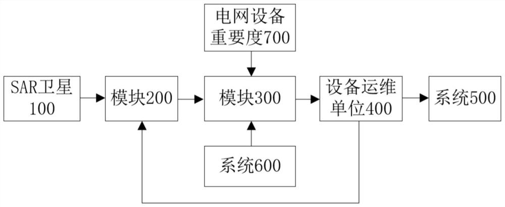
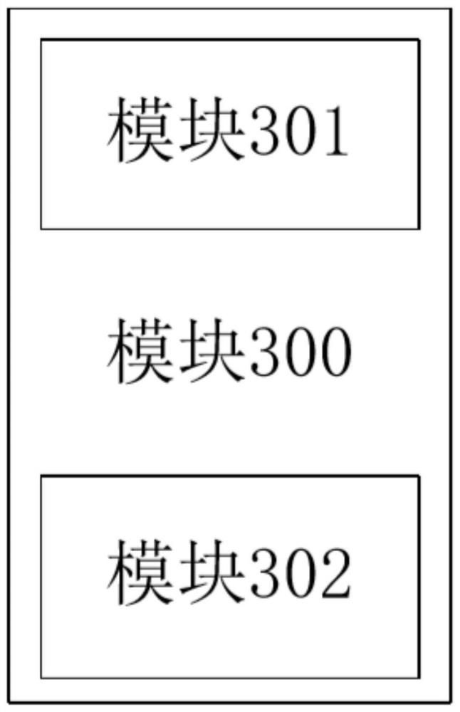
[0035] see Figure 1-5 , the present invention provides a technical solution:

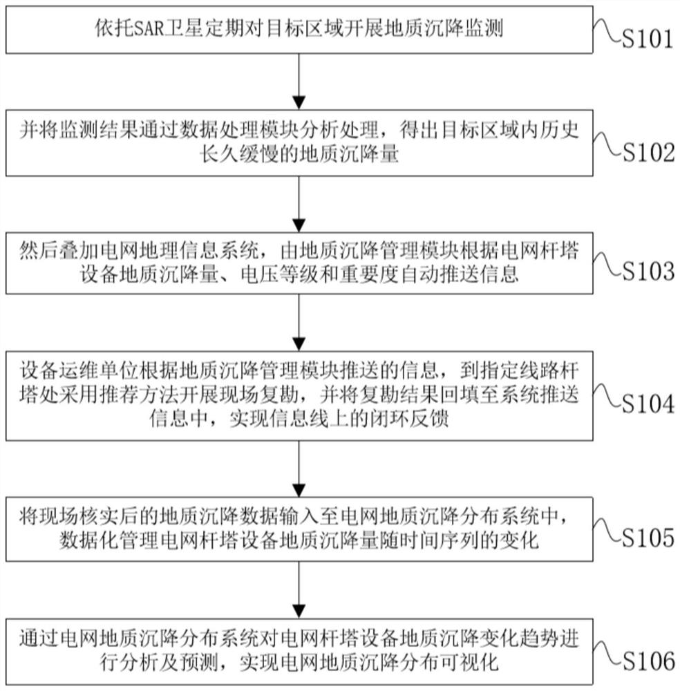
[0036] A method for monitoring hidden dangers of geological subsidence of power grid tower equipment based on SAR satellite data, comprising the following steps:

[0037] S101: Relying on SAR satellites to carry out regular monitoring of geological subsidence in the target area;

[0038] S102: Analyze and process the monitoring results through the data processing module to obtain...


PUM


Abstract

The invention discloses a monitoring method and system for hidden dangers of geological subsidence of power grid tower equipment based on SAR satellite data, which relies on SAR satellites to carry out wide-area geological subsidence monitoring on target areas, and analyzes and processes the monitoring results through a data processing module to obtain the target The long-term and slow geological subsidence in the region is superimposed on the GIS geographic information system of the power grid, and the information is automatically pushed according to the subsidence, voltage level and importance of the power grid tower equipment. The equipment operation and maintenance unit will feed back the site survey results to the system for continuous optimization The satellite image processing model and algorithm finally realize the visualization of the geological subsidence distribution of the power grid. The invention greatly reduces the workload of manual on-site measurement, shortens the acquisition period of geological subsidence results of the power grid, and realizes long-term, high-precision, large-scale and objective geological subsidence results of power transmission and distribution equipment in the power grid. The distribution and its occurrence trend provide support.

Description

technical field [0001] The invention relates to the technical field of geological subsidence monitoring of power grid pole and tower equipment, in particular to a method and system for monitoring hidden dangers of geological subsidence of power grid pole and tower equipment based on SAR satellite data. Background technique [0002] Geological subsidence is a slow-changing, long-term accumulation process, and long-term effective geological subsidence monitoring must be carried out. However, although the current traditional geological subsidence methods have high precision, they only monitor the results of discrete points or lines, and cannot monitor large-scale geological subsidence. Effective monitoring of uneven geological subsidence. [0003] my country's power grid transmission and distribution equipment covers a wide area, and the geological conditions along the way are complex. At the same time, affected by traffic, terrain and other conditions, it is difficult for oper...

Claims


Application Information

Patent Timeline
Patent Type & Authority Patents(China)
IPC IPC(8): G01C5/00
CPCG01C5/00
Inventor 张雯娟张继伟李俊鹏黄然孙斌者梅林罗哲轩
Owner 云南电网有限责任公司输电分公司
Why Eureka
Try Eureka