
An intelligent interpretation system for hyperspectral satellite on-board data and its realization method

An implementation method and spaceborne data technology, which is applied in the field of hyperspectral satellite spaceborne data intelligent interpretation system, can solve the problems of high time and labor costs, poor emergency response capabilities, and long cycles, so as to reduce time and labor costs , Solve the timeliness problem, the effect of objective and efficient extraction

Active Publication Date: 2022-07-19
潍坊绘圆地理信息有限公司 +1
View PDF12 Cites 0 Cited by
  • Summary
  • Abstract
  • Description
  • Claims
  • Application Information

AI Technical Summary

Problems solved by technology

On the one hand, due to the large number of bands in the hyperspectral image, the data volume of the image is extremely large, and it is difficult to transmit data to the ground station through relay satellite communication. In the case of limited distribution of ground stations, real-time and continuous observation become a problem
On the other hand, the downloaded images need to be analyzed by experts in the field, and the time and labor costs are huge
These two aspects have led to a long cycle from satellite acquisition to the generation of special products, and poor emergency response capabilities

Method used


Image

  • An intelligent interpretation system for hyperspectral satellite on-board data and its realization method
  • An intelligent interpretation system for hyperspectral satellite on-board data and its realization method
  • An intelligent interpretation system for hyperspectral satellite on-board data and its realization method

Examples


Embodiment 1

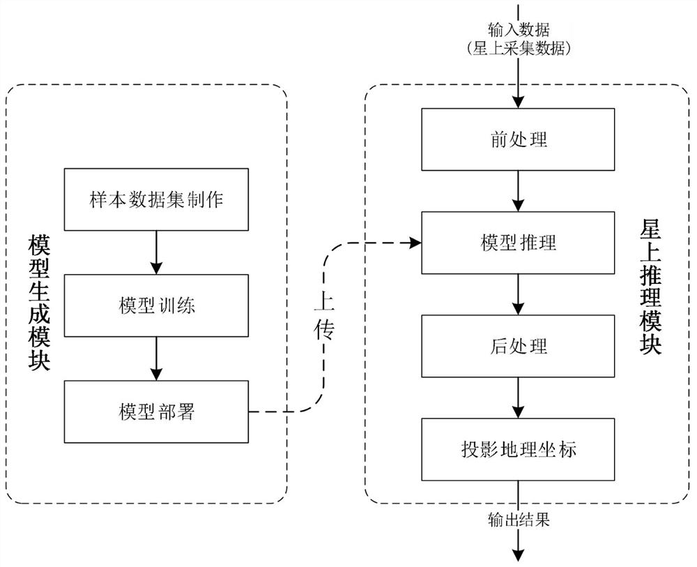
[0057] Example 1, as figure 1 As shown, an intelligent interpretation system for hyperspectral satellite onboard data includes a model generation module and an on-board inference module. The model generation module is used for training and deploying models, including sample data set production, model selection and training, and model quantification deployment. , the on-board inference module is used to intelligently interpret the newly collected data using the trained neural network, including input data preprocessing, sliding window slicing, model inference, inference result splicing and post-processing, projected geographic coordinates and transmission processing result.

[0058] The model generation module in the space-borne hyperspectral image data interpretation system uses historical data on the ground to train deep learning models for different tasks, and uploads them to the satellite. The on-board inference module uses the on-board AI to accelerate the computing power ...


PUM


Abstract

The present application discloses a hyperspectral satellite onboard data intelligent interpretation system and its implementation method, including a model generation module and an on-board inference module. The model generation module is used for training and deploying models, including sample data set production, model selection and Training and model quantization deployment, the onboard inference module is used to intelligently interpret the newly collected data using the trained neural network, including input data preprocessing, sliding window slicing, model inference, inference result splicing and post-processing, projection Geographic coordinates and send processing results. It has the following advantages: it can extract target information more objectively and efficiently, form thematic products, and reduce time and labor costs; by deploying the neural network on the satellite, users do not need to download the original image to the ground, which can solve the problem of timeliness, The cycle of information acquisition is greatly shortened.

Description

technical field [0001] The invention relates to a hyperspectral satellite onboard data intelligent interpretation system and an implementation method thereof, belonging to the technical field of image data recognition. Background technique [0002] In recent years, remote sensing technology has been widely used in ecological monitoring, economic development, military reconnaissance, resource exploration, disaster early warning, etc. Remote sensing satellites can be divided into high-resolution satellites, radar satellites, multi-spectral hyper / spectral satellites, etc., according to different sensors. Compared with high-resolution and radar satellites, hyperspectral satellites can capture a wider frequency range and higher resolution. Therefore, it is more advantageous in the analysis of ground objects. [0003] The traditional interpretation of hyperspectral image data requires the transmission of hyperspectral images from satellites to ground receiving stations. After a s...

Claims


Application Information

Patent Timeline
Patent Type & Authority Patents(China)
IPC IPC(8): G06F30/27G06T7/00G06N3/04G06N3/08G06N5/04
CPCG06F30/27G06T7/0002G06N5/04G06N3/04G06N3/08G06T2207/10032G06T2207/20081G06T2207/20084G06T2207/20104
Inventor 颜军蒋晓旭邓剑文梁谐明龚永红
Owner 潍坊绘圆地理信息有限公司
Learn More