A Multi-sensor Remote Sensing Image Matching Method

A remote sensing image and matching method technology, applied in the field of satellite image processing, can solve the problems of insufficient robustness, weak applicability of scale and rotation differences between images, and failure to use phase-consistent direction information, etc., to improve production efficiency and improve efficiency effect

Active Publication Date: 2018-01-12
SOUTHWEST JIAOTONG UNIV
View PDF3 Cites 0 Cited by
  • Summary
  • Abstract
  • Description
  • Claims
  • Application Information

AI Technical Summary

Problems solved by technology

Phase consistency is a feature extraction algorithm with illumination and contrast invariance. It has been widely used in the field of remote sensing image matching. However, the current method based on phase consistency is not suitable for scale and rotation differences between images. Moreover, only the eigenvalues ​​of phase consistency are used, but the direction information of phase consistency is not used, and the potential of phase consistency in feature extraction and description cannot be fully tapped, and the performance is not robust enough. Therefore, the present invention will The consistency calculation model is extended, using its odd symmetric filter to construct the phase consistency feature direction, and then using its eigenvalue and feature direction, with the help of the idea of ​​SIFT descriptor, to construct a local feature descriptor—local phase consistency direction Histogram (local histogram of oriented phase congruency, LHOPC), which can better resist the scale, rotation and radiation differences between images, so as to achieve accurate matching of multi-sensor remote sensing images

Method used


Image

  • A Multi-sensor Remote Sensing Image Matching Method
  • A Multi-sensor Remote Sensing Image Matching Method
  • A Multi-sensor Remote Sensing Image Matching Method

Examples


Embodiment Construction

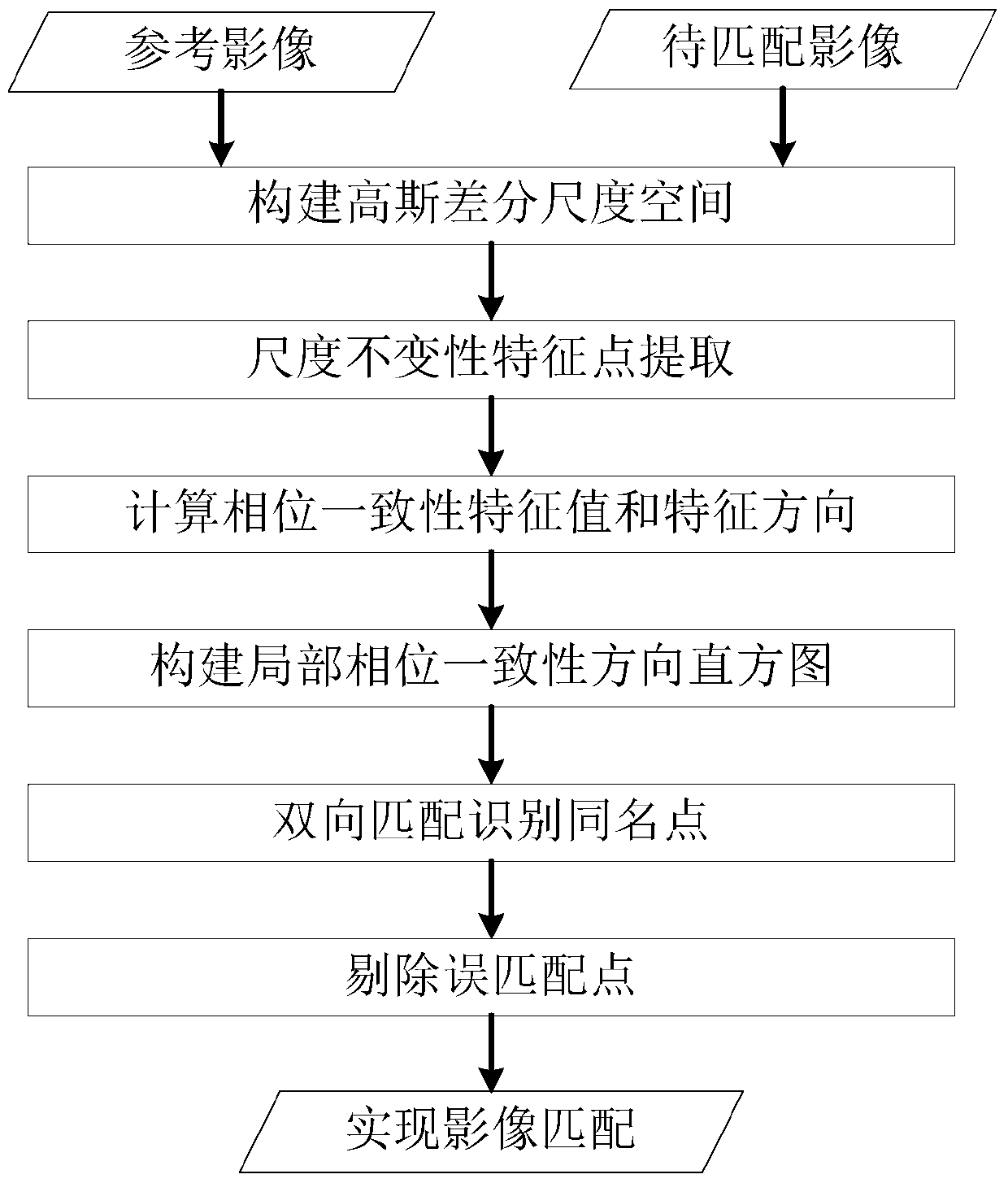
[0024] The present invention will be further described below in conjunction with accompanying drawing:

[0025] A multi-sensor remote sensing image matching method, the specific steps of its realization are:

[0026] Step 1. Use Gaussian kernel functions of different scales σ to process the reference image I 1 and the image to be matched I 2 Filtering is performed to form a Gaussian scale space, and the DoG scale space is generated by the difference between two adjacent layers of images in the Gaussian scale space.

[0027] In the DoG space, compare each pixel of the middle layer (except the bottom and top layers) with 8 adjacent pixels of the same layer and 18 adjacent pixels of the upper and lower layers, a total of 26 pixels, if If the DoG value of the point is the largest or the smallest, it is considered as a candidate feature point, and then the point with low contrast and located on the edge is removed to obtain the final feature point PointIi (i=1,2,3,...,N ).

[0...


PUM


Abstract

The invention discloses a multi-sensor remote sensing image matching method, which belongs to the technical field of satellite image processing and can effectively solve the problems of geometric deformation and radiation difference among multi-sensor images. Firstly, the Gaussian difference scale space of the image is established, and feature point detection is performed in this space. Then introduce a phase consistency model with illumination and contrast invariance, and expand it to construct phase consistency direction information. At the same time, with the help of the idea of ​​SIFT descriptor, use phase consistency eigenvalues ​​and feature directions to construct a local feature description Symbol—local phase coherence direction histogram. Finally, the Euclidean distance between descriptors is used as the similarity measure to identify the points with the same name, and eliminate the wrong matching points, so as to realize the precise matching of remote sensing images. Compared with the traditional matching method, the invention can more effectively overcome the geometric deformation and radiation difference between remote sensing images, and improve the accuracy of image matching. Mainly used for satellite image processing.

Description

technical field [0001] The invention belongs to the technical field of satellite image processing, in particular to the matching technology of remote sensing images. Background technique [0002] Image matching is essentially the process of identifying points with the same name between two or more images, and is widely used in remote sensing image registration, image stitching, and change detection. Due to the difference in imaging mechanism and spectral characteristics, there are often significant geometric and radiometric differences between multi-sensing remote sensing images, which makes it difficult to automatically identify points with the same name between images. [0003] Recently in the field of computer vision, local feature descriptors have been developed rapidly and widely used in image matching. The most famous local feature description is the Scale Invariant Feature Transform (SIFT) operator. Due to its rotation and scale invariance, SIFT has been widely used ...

Claims


Application Information

Patent Timeline
Patent Type & Authority Patents(China)
IPC IPC(8): G06T7/33
CPCG06T2207/10032G06T2207/20212
Inventor 叶沅鑫慎利曹云刚
Owner SOUTHWEST JIAOTONG UNIV
Why Eureka
Try Eureka