Determining stockpile volume based on digital aerial images and three-dimensional representations of a site

a three-dimensional representation and site technology, applied in image analysis, image enhancement, instruments, etc., can solve the problems of time-consuming and laborious processes, conventional systems are not able to quickly and easily identify stockpiles and estimate stockpile volumes, etc., to achieve accurate determination of stockpile volumes

Active Publication Date: 2019-01-24
SKYCATCH
View PDF0 Cites 20 Cited by
  • Summary
  • Abstract
  • Description
  • Claims
  • Application Information

AI Technical Summary

Benefits of technology

[0004]Embodiments of the present disclosure provide benefits and/or solve one or more of the foregoing or other problems in the art with systems and methods for automatically identifying stockpiles and determining stockpile volumes utilizing digital aerial images of a site captured by a UAV. In particular, in one or more embodiments, the disclosed systems and methods utilize digital aerial images captured by a UAV to generate a two-dimensional representation and three-dimensional representation of a site. The disclosed systems and methods can identify pote...

Problems solved by technology

Although conventional UAV systems can capture digital aerial images of a site, such systems are unable to quickly and easily identify stockpiles and estimate stockpile volume.
Rather, conventional systems require time consuming and laborious...

Method used


Image

  • Determining stockpile volume based on digital aerial images and three-dimensional representations of a site
  • Determining stockpile volume based on digital aerial images and three-dimensional representations of a site
  • Determining stockpile volume based on digital aerial images and three-dimensional representations of a site

Examples


Embodiment Construction

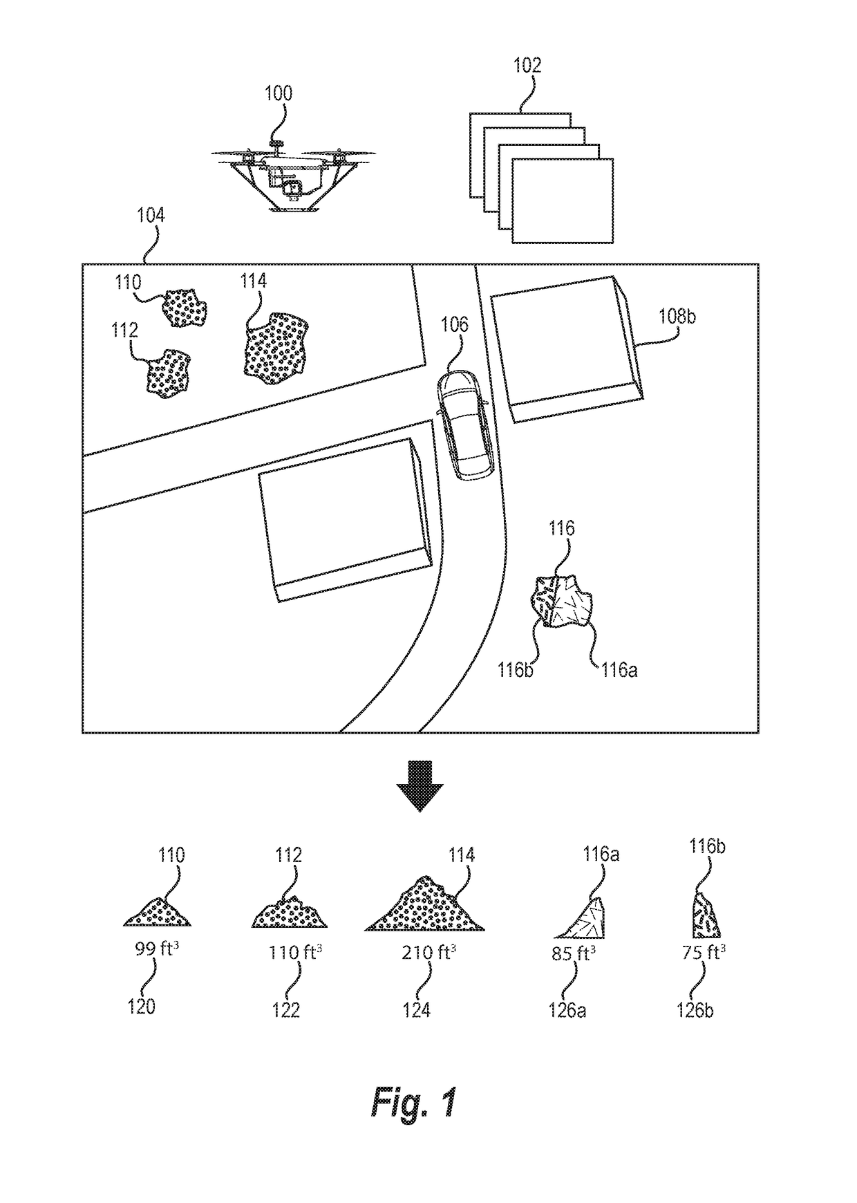
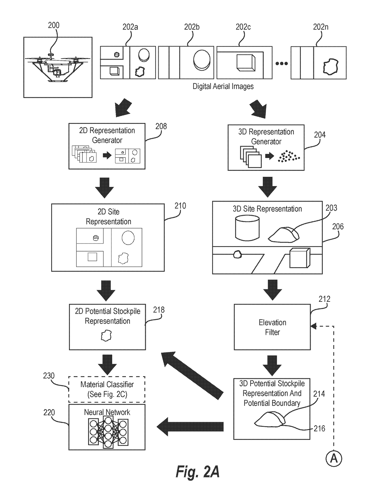
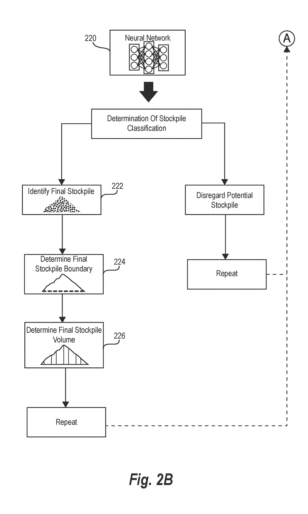
[0020]The present disclosure includes various embodiments and features of an aerial stockpile analysis system and corresponding processes that assist in identifying stockpiles and determining stockpile volume on a site based on digital aerial images. In particular, in one or more embodiments the aerial stockpile analysis system generates a three-dimensional model of a site utilizing digital aerial images captured by a UAV in flight and then utilizes the three-dimensional model of the site to identify potential stockpiles. Moreover, the aerial stockpile analysis system can analyze two-dimensional features and the three-dimensional features of the potential stockpiles utilizing a neural network to confirm that the potential stockpiles reflect actual stockpiles. Further, the aerial stockpile analysis system can determine volumes of the stockpiles based on the three-dimensional representation of the site.

[0021]To illustrate, in one or more embodiments, the aerial stockpile analysis syst...


PUM


Abstract

Systems and methods are disclosed for utilizing digital aerial images to determine stockpile volumes. In particular, in one or more embodiments, the disclosed systems and methods utilize a UAV to capture a plurality of digital aerial images portraying stockpiles on a site. The disclosed systems and methods can generate a two-dimensional representation of the site and a three-dimensional representation of the site based on the plurality of digital aerial images. Moreover, the disclosed systems and methods can apply an elevation filter to the three-dimensional representation of the site to identify potential stockpiles. Further, the disclosed systems and methods can utilize a neural network to analyze two-dimensional features and three-dimensional features of the potential stockpiles to identify final stockpiles. The disclosed systems and methods can then utilize three-dimensional stockpile representations to determine stockpile volumes.

Description

BACKGROUND[0001]In recent years, individuals and businesses have increasingly utilized UAVs to perform a variety of tasks. Indeed, because of the reduced cost of UAVs relative to chartering manned aerial vehicles, businesses and individuals utilize UAVs to perform a variety of flight tasks that have traditionally been cost-prohibitive. For example, it is becoming increasingly common to utilize UAVs to perform flight missions for capturing digital aerial images of a site in construction, land management, mining, or other applications.[0002]Although some conventional systems are able to utilize UAVs to capture digital aerial images of a site, such conventional systems have a number of shortcomings. For example, many customers in construction, land management, or mining applications manage large material stockpiles and need updated estimates of stockpile volumes. Although conventional UAV systems can capture digital aerial images of a site, such systems are unable to quickly and easily...

Claims


Application Information

Patent Timeline
IPC IPC(8): G06K9/00G06T7/62G06K9/62G06K9/46G06T17/05G06V10/764G06V20/13G06V20/17
CPCG06K9/0063G06T7/62G06K9/6256G06K9/4609G06K9/627G06T2207/10024G06K9/6218G06T2207/10032G06T2207/10028G06T2207/30181G06T2207/20081G06T17/05G06T7/12G06T2207/20084G06V20/13G06V10/443G06V20/17G06V10/82G06V10/763G06V10/764G06F18/23213G06F18/23G06F18/24G06F18/214G06F18/2413
Inventor ALVAREZ GONZALEZ, RODOLFO RUBENBARAJAS HERNANDEZ, MANLIO FRANCISCOROMO MORALES, LEONARDO FELIPECHEN, DAVID
Owner SKYCATCH
Why Eureka
Try Eureka