Computer Vision Systems and Methods for Geospatial Property Feature Detection and Extraction from Digital Images

a computer vision and feature detection technology, applied in the field of computer vision, can solve the problems of system time-consuming and difficult use, system can only detect certain types of objects, and require a great deal of manual input by users

Active Publication Date: 2019-06-20
GEOMNI INC
View PDF11 Cites 20 Cited by
  • Summary
  • Abstract
  • Description
  • Claims
  • Application Information

AI Technical Summary

Problems solved by technology

However, such systems are often time-consuming and difficult to use, and require a great deal of manual input by a user.
Still further, such systems can only detect certain types of objects and can only detect roof features, not other objects in a scene such as trees, pools, bodies of water, landscaping, sport courts, etc.

Method used


Image

  • Computer Vision Systems and Methods for Geospatial Property Feature Detection and Extraction from Digital Images
  • Computer Vision Systems and Methods for Geospatial Property Feature Detection and Extraction from Digital Images
  • Computer Vision Systems and Methods for Geospatial Property Feature Detection and Extraction from Digital Images

Examples


Embodiment Construction

[0028]The present disclosure relates to a computer vision systems and methods for geospatial property feature detection and extraction from digital images, as discussed in detail below in connection with FIGS. 1-19. As will be discussed in greater detail below, the system can detect and extract both geometric and non-geometric features from digital images.

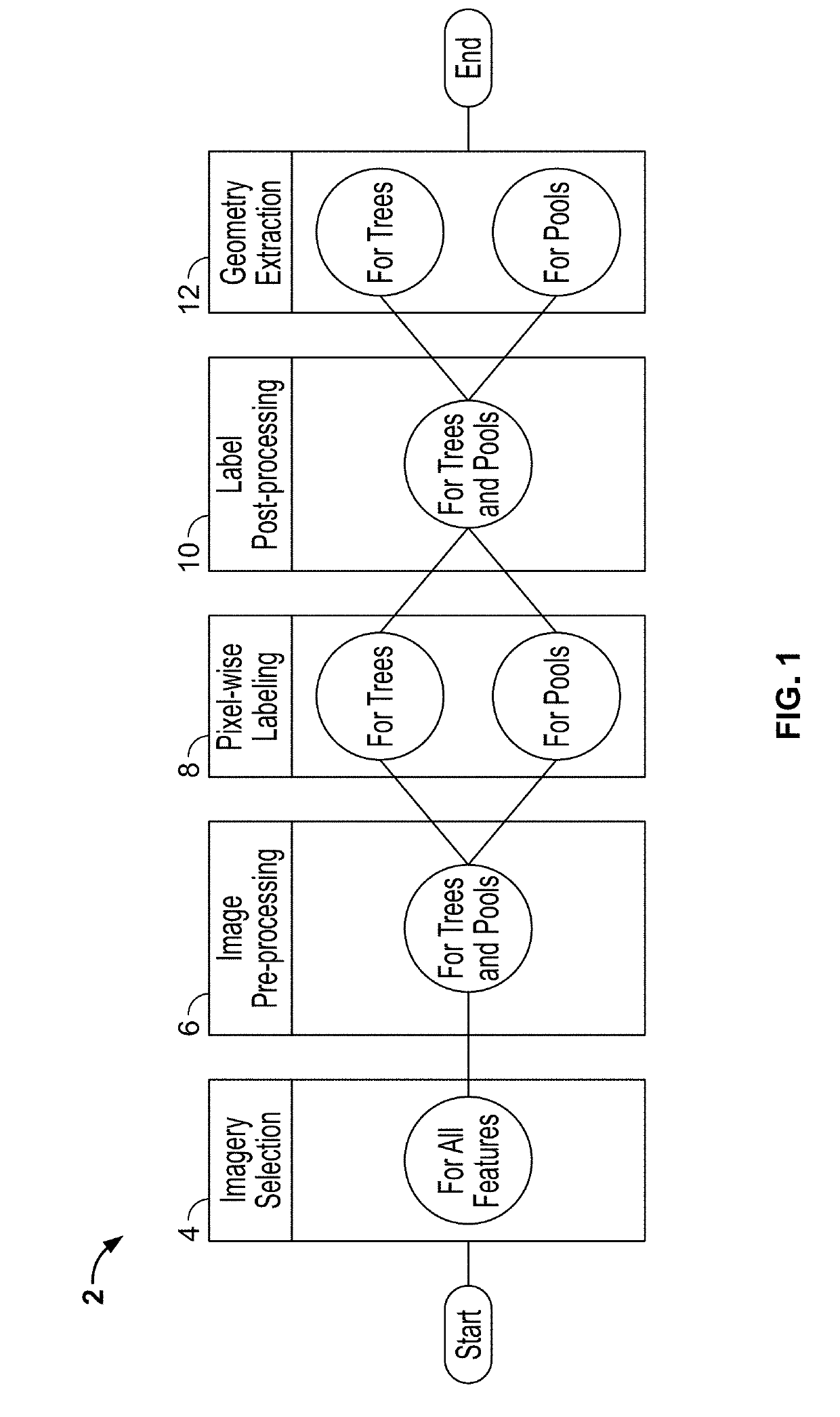
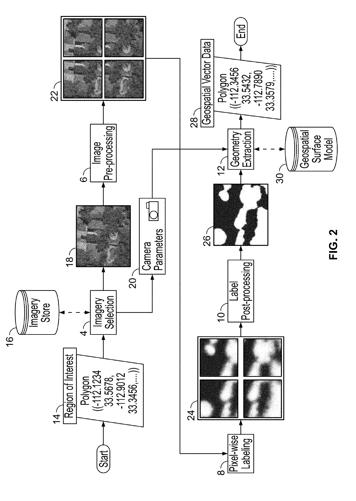
[0029]FIG. 1 is a flowchart showing processing steps 2 carried out by the geospatial property feature detection and extraction system of the present disclosure. In particular, the process flow can be thought of as a computation graph organized into a pipeline of five steps or phases. FIG. 1 shows the order of the phases: (1) imagery selection step 4, (2) image pre-processing step 6, (3) pixel-wise labeling step 8, (4) label post-processing step 10; and finally, (5) geometry extraction step 12. Each property feature which the system detects can use unique parameters or algorithms in each phase, but for efficiency, the parameters and...


PUM


Abstract

Systems and methods for property feature detection and extraction using digital images. The image sources could include aerial imagery, satellite imagery, ground-based imagery, imagery taken from unmanned aerial vehicles (UAVs), mobile device imagery, etc. The detected geometric property features could include tree canopy, pools and other bodies of water, concrete flatwork, landscaping classifications (gravel, grass, concrete, asphalt, etc.), trampolines, property structural features (structures, buildings, pergolas, gazebos, terraces, retaining walls, and fences), and sports courts. The system can automatically extract these features from images and can then project them into world coordinates relative to a known surface in world coordinates (e.g., from a digital terrain model).

Description

CROSS-REFERENCE TO RELATED APPLICATIONS[0001]This application claims the benefit of U.S. Provisional Patent Application No. 62 / 619,321 filed on Jan. 19, 2018 and U.S. Provisional Patent Application No. 62 / 596,172 filed on Dec. 8, 2017, the entire disclosures of which are expressly incorporated herein by reference.BACKGROUNDTechnical Field[0002]The present disclosure relates generally to the field of computer vision. More particularly, the present disclosure relates to computer vision systems and methods for geospatial property feature detection and extraction from digital images (e.g., from aerial images, satellite images, etc.).Related Art[0003]Accurate and rapid identification and estimation of objects in digital images such as aerial images, satellite images, ground-based images, etc., is increasingly important for a variety of applications. For example, information related to roofs of buildings is often used by construction professionals to specify materials and associated costs...

Claims


Application Information

Patent Timeline
Patent Type & Authority Applications(United States)
IPC IPC(8): G06K9/46G06K9/00G06K9/32G06T7/80G06T7/60G06T17/05G06T3/40G06V10/48G06V10/56G06V10/764
CPCG06K9/4604G06K9/00637G06K9/3233G06T7/80G06T7/60G06T17/05G06T3/4038G06T11/00G06V20/64G06V20/176G06V10/48G06V10/56G06V10/82G06V10/764
Inventor PORTER, BRYCE ZACHARYJUSTUS, RYAN MARKCALL, JOHN CALEB
Owner GEOMNI INC
Why Eureka
Try Eureka