Practical method for landslide detection in large space

a landslide detection and large space technology, applied in scene recognition, instruments, computing, etc., can solve the problems of inability to accurately identify the object to which the pixel belongs, lack of spatial characteristics of objects, time-consuming and laborious, etc., to avoid radiometric correction, efficient landslide extraction, reliable and practical

Active Publication Date: 2022-01-13
AEROSPACE INFORMATION RES INST CAS
View PDF2 Cites 5 Cited by
  • Summary
  • Abstract
  • Description
  • Claims
  • Application Information

AI Technical Summary

Benefits of technology

[0028]The beneficial effects of this invention are as follows: this invention avoids radiometric correction and outlier by detecting landslide from synthetic images. That guarantees practical applicability of the proposal. Firstly, detecting potential landslides can avoid the imbalanced sample distribution issue between background objects and landslides when training the landslide detection model. The landslide

Problems solved by technology

However, this method only takes into account the features of a single pixel, and lacks the spatial characteristics of the object that the pixel belongs to.
At present, three strategies have been developed to set threshold: in the first strategy, the threshold is set manually, which is time-consuming and labor-consuming, and the rules constructed are often not robust.
Therefore, it is difficult to detect multiple land

Method used


Image

  • Practical method for landslide detection in large space
  • Practical method for landslide detection in large space
  • Practical method for landslide detection in large space

Examples


Embodiment Construction

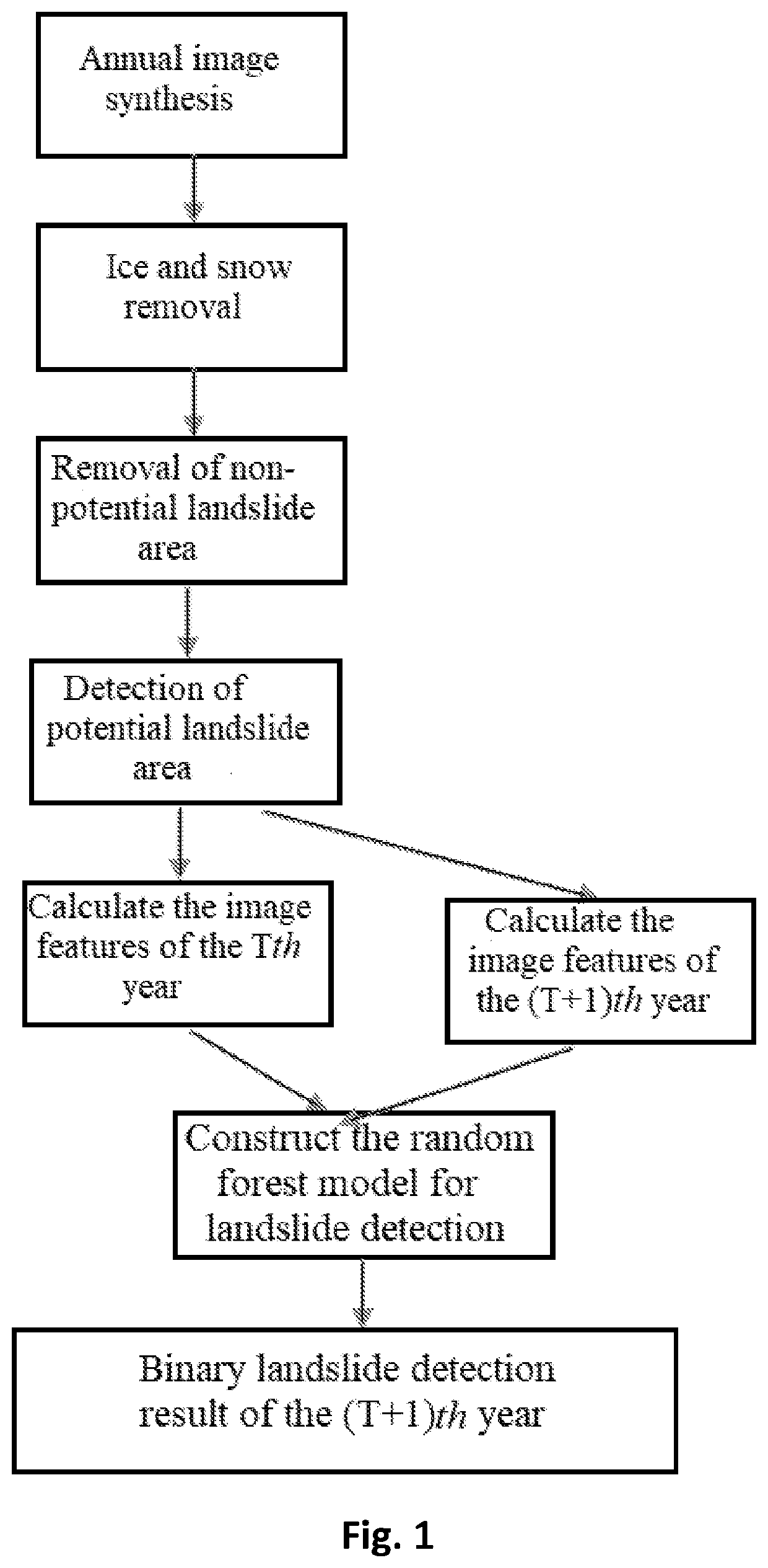
[0033]In order to deepen the understanding of this invention, this invention will be further elaborated based on an embodiment. This embodiment is only used to explain this invention and does not forma limitation on the protection scope of this invention.

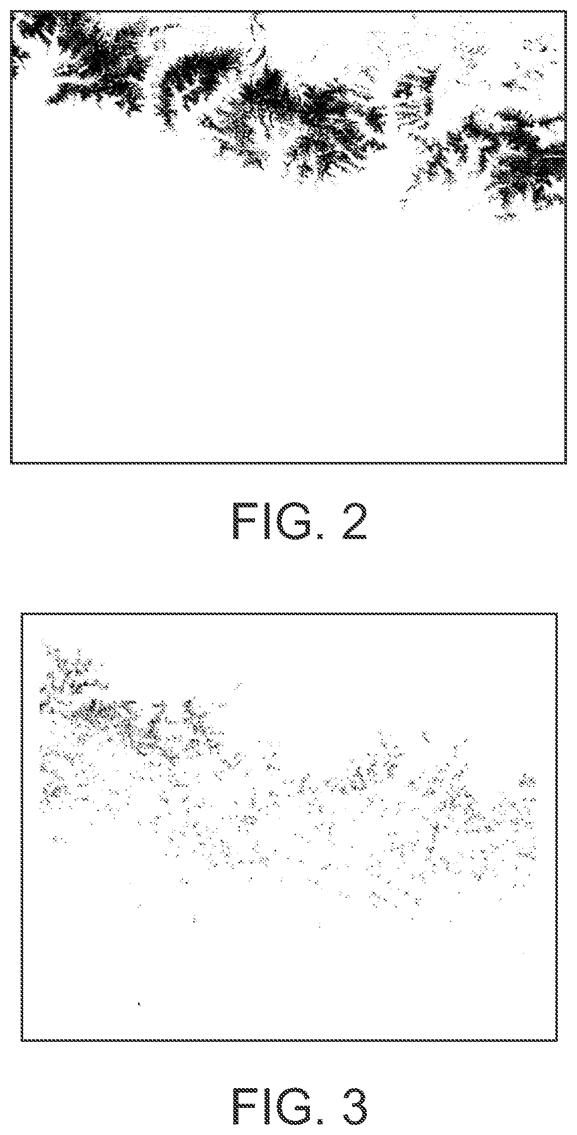
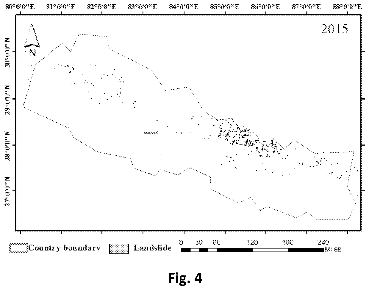
[0034]As shown in FIGS. 1, 2, 3 and 4, this embodiment provides a practical method for landslide detection in large space, which comprises the following steps:

[0035]Step 1: Image synthesis

[0036]Generate annual synthesis on the Landsat 8 images of the whole territory of region A (Nepal) from 2015 to 2018 respectively based on the Google Earth engine by using the 50% maximum NDVI strategy to generate the annual synthetic images. The specific strategy of image synthesis is as follows:

[0037](1) Collect all the Landsat 8 images covering the whole territory of region A (Nepal) of the year y (y=2015, 2016, 2017, 2018) respectively;

[0038](2) Calculate the NDVI values of each pixel in all the Landsat 8 images of year y (y=2015, 2016, 2017, 2...


PUM


Abstract

This invention discloses a practical method for landslide detection in large space, which comprises the following steps: image synthesis, ice and snow detection, removal of non-potential landslide area, detection of potential landslide area, feature calculation, landslide detection model construction and precision validation; this invention avoids radiometric correction and outlier by detecting landslide from synthetic image. That guarantees practical applicability of the proposal. Firstly, detecting potential landslides can avoid the imbalanced sample distribution issue between background objects and landslides when training the landslide detection model. The landslide is further detected by building a random forest model based on the spectral features and textural features of potential landslide pixels in different neighboring time domains. It fully considers the changes of objects in different time domains, and lays a foundation for efficient landslide extraction. This model is relatively reliable and practical for automatically detecting landslide from large-scale images.

Description

FIELD OF THE INVENTION[0001]This invention relates to the technical fields of remote sensing image processing and machine learning, in particular to a practical method for landslide detection in large space.BACKGROUND OF THE INVENTION[0002]At present, the methods of remote sensing landslide detection are different according to different data types. The landslide detection methods based on optical image synthesize spectral, textural, shape and morphological features, and are generally grouped to two categories: (1) Pixel based detection; (2) Object oriented detection. Pixel based detection takes each pixel as the object of interest, calculates statistics on the spectral and textural features of each pixel in the image, and detects landslide by setting threshold. However, this method only takes into account the features of a single pixel, and lacks the spatial characteristics of the object that the pixel belongs to. Therefore, the characteristics of pixels among an object lack necessa...

Claims


Application Information

Patent Timeline
IPC IPC(8): G06K9/00G06K9/44G06K9/46G06K9/62
CPCG06K9/0063G06K9/44G06K9/6262G06K9/4652G06K9/4661G06N20/10G06V20/194G06V20/13G06V10/60G06V10/58G06V10/77G06V10/56G06V10/34G06F18/217
Inventor YU, BOCHEN, FANG
Owner AEROSPACE INFORMATION RES INST CAS
Why Eureka
Try Eureka