System for matching nodes of spatial data sources

a technology of spatial data and matching nodes, applied in the field of conflicting, can solve problems such as scaling, skewing, offset, rotation, and source data that is faulty in some respects, and can not be spatially corr

Inactive Publication Date: 2002-06-18
DIGITALGLOBE INC
View PDF12 Cites 14 Cited by
  • Summary
  • Abstract
  • Description
  • Claims
  • Application Information

AI Technical Summary

Problems solved by technology

One of the problems, however, is that typically the source data is faulty in some respects.
For example, because of the way the data was obtained, it may not be spatially correct.
There may be problems with scaling, skewing, offset, rotation, and other similar problems.
Typically, these distortions are not systematic distortions that can be corrected in a systematic fashion.
This results sometimes

Method used


Image

  • System for matching nodes of spatial data sources
  • System for matching nodes of spatial data sources
  • System for matching nodes of spatial data sources

Examples


Embodiment Construction

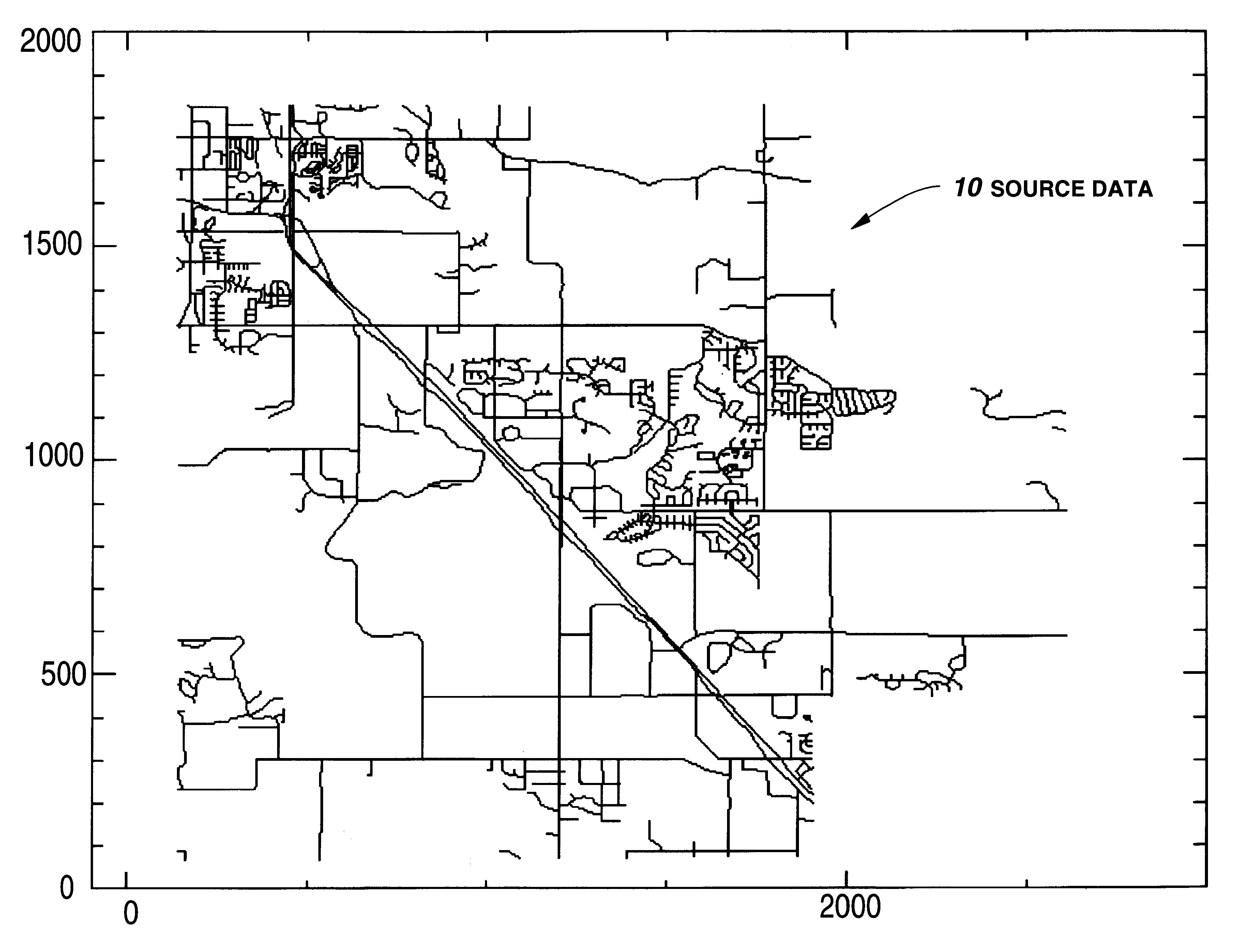
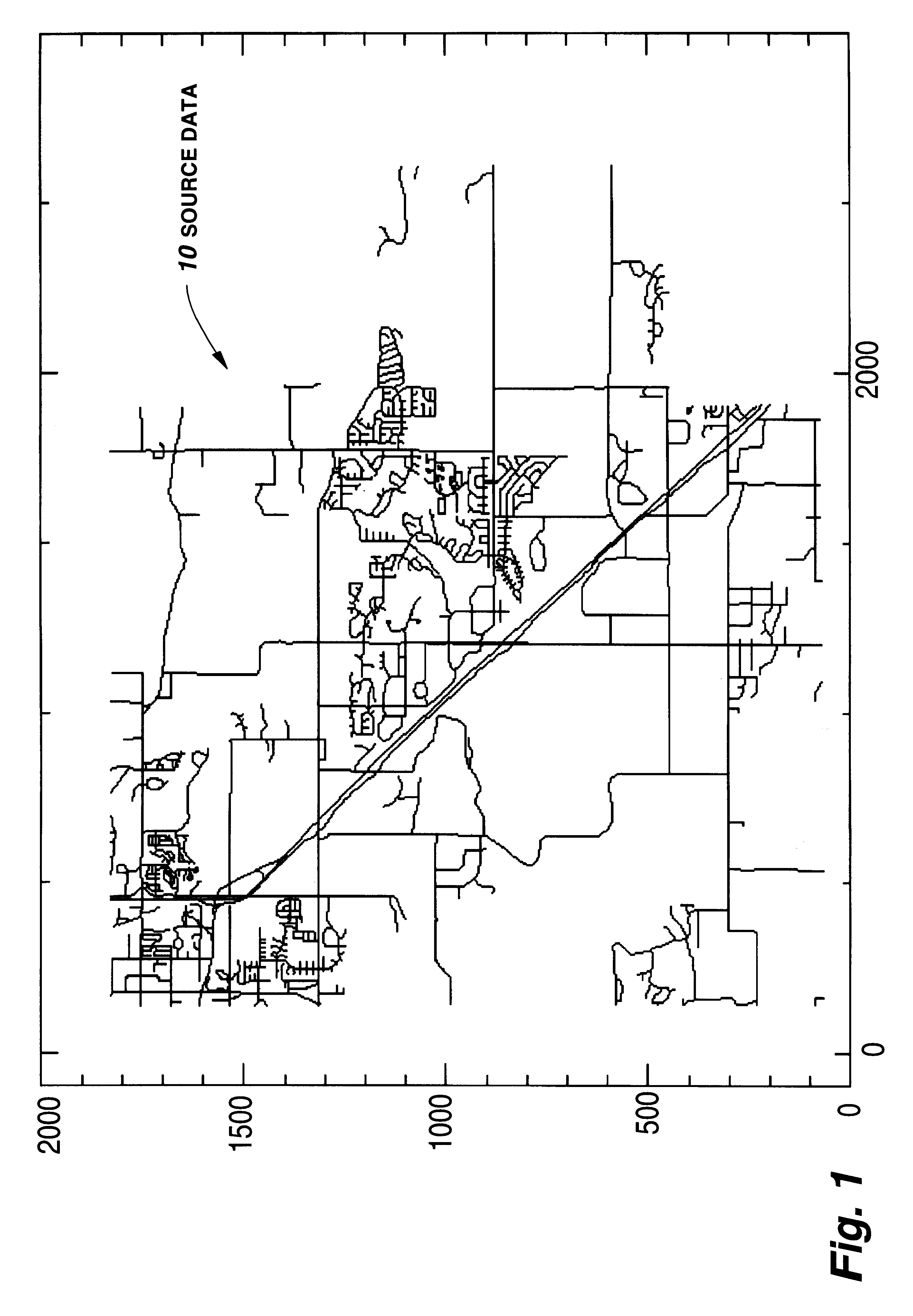
FIG. 1 illustrates an example of a set of source data 10. As illustrated in FIG. 1, the source data 10 is representative of spatial data such as roads that are typically be illustrated in a map. In fact, the source data illustrated in FIG. 1 is a portion of the diagonal Highway 36 that is located between Boulder, Colo. and Longmont, Colo. The data is provided in vector format. The vector data indicates the beginning of the vector and its direction and length, to form each of the lines that indicate the roads shown in FIG. 1. Vectors can be formed from either straight lines or predetermined curves. The vector data can be provided in an ASCII format so that it can be decoded and read using standard ArcView software available from Esri Inc., Redlands, Calif. Of course, the data of FIG. 1 is represented in the form of a two-dimensional map having spatial coordinates. The data can similarly be representative of three-dimensional spatial coordinates or other additional coordinate systems ...


PUM


Abstract

A system for matching nodes of different spatial data sources. The system matches or ties a node from one data source to another data source. The present invention uses a highly accurate exclusion technique for excluding potential corresponding nodes of a second data source. Potential corresponding nodes are selected using node degree comparison, adjacency, fourier descriptor analysis of shapes formed by connecting paths between a node under investigation and a secondary node associated with that node under investigation, an analysis of total length to secondary nodes, an angle analysis to eliminate reflections, a secondary node degree analysis, and a surrounding node correlation coefficient comparison. Using one or more of these techniques in various combinations can result in the selection of a potential corresponding node with a high degree of accuracy.

Description

A. Field of the InventionThe present invention pertains generally to conflation, and more particularly to the matching of nodes of spatial data from different data sources.B. Description of the BackgroundData can be represented spatially to provide a format for pictorially displaying that data. The displayed data may take the form of a map, a graph, charts, holograms, and other various types of two- and three-dimensional representations. For example, the U.S. government provides vector data (source data) that is known as "TIGER", data that is representative of maps that cover the entire United States. This data indicates roads and other geographical landmarks, as well as what is referred to as "attribute data". Attribute data is located at the nodes between the vectors of the source data, and provides information such as street names and addresses, zoning, school districts, average home prices, average income, and various other demographic data that is associated with the particular...

Claims


Application Information

Patent Timeline
IPC IPC(8): G06T17/50G06K9/64G06T17/05
CPCG06K9/6211G06T17/05Y10S707/99948Y10S707/99945G06V10/757
Inventor YUEN, PATRICK W.
Owner DIGITALGLOBE INC
Why Eureka
Try Eureka