Combined global positioning system receiver and radio with enhanced display features

a global positioning system and receiver technology, applied in the field of combined gps receivers and radio units, can solve the problems of limiting the utility of combined gps/radio units, unable to determine the distance of users from other radio users in their group or family, and unable to accurately assess the distance between users and other users, so as to quickly determine the distance between units.

Inactive Publication Date: 2005-02-01
GARMIN
View PDF17 Cites 110 Cited by
  • Summary
  • Abstract
  • Description
  • Claims
  • Application Information

AI Technical Summary

Benefits of technology

The present invention solves the above-described problems and provides a distinct advance in the art of radios in general, and combined GPS / radio units in particular. One embodiment of the present invention provides a combined GPS / radio unit that is operable to display not only an indication of the location of other such units, but also the distance between two or more units. This permits a user to closely monitor the location of other users and to accurately assess the distance between himself or herself and the other users. In preferred forms, this is accomplished by displaying a plurality of radii rings around the displayed location of the user's unit, wherein the radii rings each correspond to a particular distance. This enables a user to quickly determine the distance between his or her unit and any other unit for which location data has been received and displayed. The distance between units may also be represented by a line segment extending between the displayed location of two units and text representative of the distance.
Another embodiment of the present invention provides a combined GPS / radio unit that is operable to display additional location-type information for other units such as track logs and track back information. A similar embodiment of the invention allows users to gather location data for way points such as campsites, trail heads, and bodies of water and to transmit the location data along with textual identifiers to other units. The other units may then display indications of the locations of the way points and the textual identifiers so that all units in communication with one another may display such information without requiring each user to personally visit each way point.
Another embodiment of the present invention provides a combined GPS / radio unit that permits a user to selectively change the perspective or vantage point from which location data and other information may be viewed. This permits a user to select a perspective from which to view the position of other units and way points and to then change the perspective, if desired, as the units move.

Problems solved by technology

Unfortunately, currently-proposed combined GPS / radio units suffer from several limitations that limit their utility.
For example, proposed designs provide no means for users to determine their distance from other radio users in their group or family.
Another limitation of currently-proposed combined GPS / radio units is that transmitted location data quickly becomes stale or outdated as the units move from place to place.
This is a problem because a user may incorrectly rely upon previously-transmitted location data to determine the location of another user.
Another limitation of currently-proposed combined GPS / radio units is that, although they can display the location of other such units, they are not operable to display other useful location-type information for other units such as track logs and track back information.
Another limitation of currently-proposed combined GPS / radio units is that they provide no means for users to gather and transmit to other units location data for way points such as campsites, trail heads, and bodies of water.
Another limitation of currently-proposed combined GPS / radio units is that they permit the display of location data from one perspective only.
This is a problem because it is often desirable to change the perspective or vantage point from which such information is viewed to compensate for movement of the units.
Another limitation of currently-proposed combined GPS / radio units is that users often unknowingly move beyond the communication range of the units and therefore lose communications.
Unfortunately, however, such indicators typically only provide such alerts after communications have already been lost or seriously degraded.

Method used


Image

  • Combined global positioning system receiver and radio with enhanced display features
  • Combined global positioning system receiver and radio with enhanced display features
  • Combined global positioning system receiver and radio with enhanced display features

Examples


Embodiment Construction

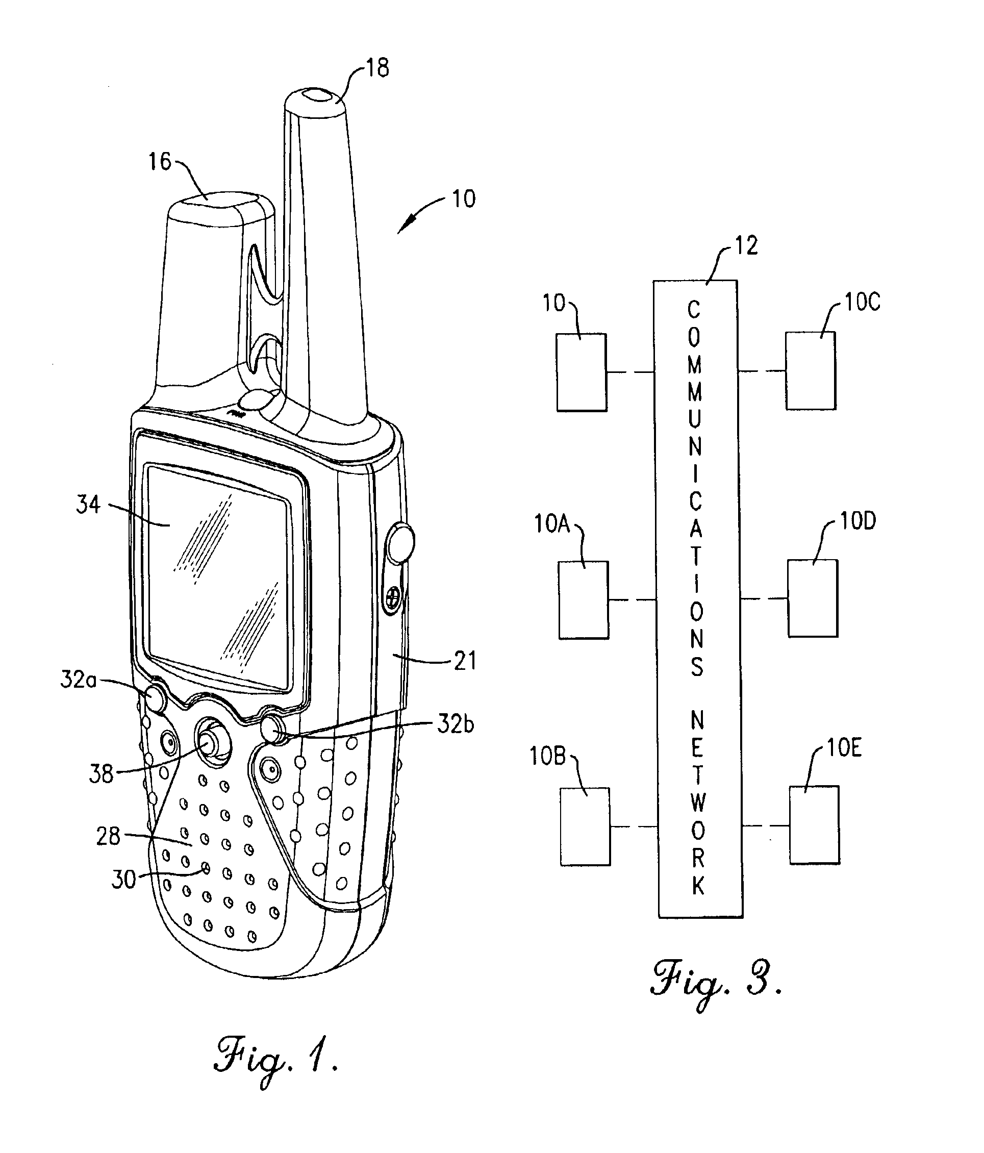
Turning now to the drawing figures, and particularly FIGS. 1-3, a portable radio unit 10 constructed in accordance with a preferred embodiment of the invention is illustrated. The radio 10 is preferably a combined GPS / radio unit that may transmit and receive voice communications, determine its location using the GPS, and transmit location data and other information to other such units 10A, 10B, 10C, 10D and 10E over a wireless network 12. In the preferred embodiment of the present invention, units 10 and 10A-10E communicate with one another over a public radio network such as the Family Radio Service (FRS); however, the network 12 may also be a cellular radio network, a personal communications service (PCS) network, or any other conventional wireless communications network. While six units 10 and 10A-10E are shown on the exemplary embodiment of FIG. 3, only two such units are necessary for the purposes of the present invention.

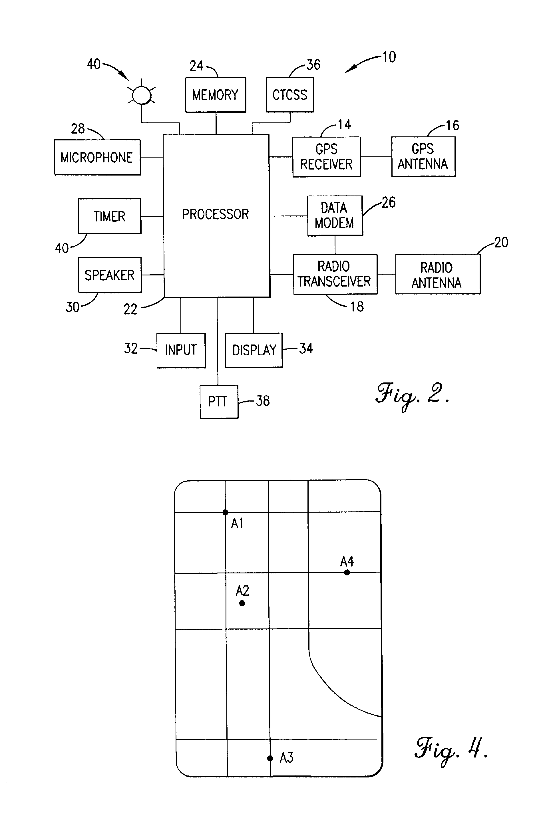
Referring to FIGS. 1 and 2, the preferred unit 10 compri...


PUM


Abstract

A portable GPS / radio unit (10) communicates over a wireless radio network (12) with at least one other such unit (10A-10E). The unit (10) may transmit radio signals over the network (12) indicative of the unit's location and receive similar radio signals from other such units. The unit (10) is operable to display an indication of the distance between two or more units, an indication of the amount of time that has elapsed since location data was last received from another unit, a track log or track back information for another unit, and an indication if the unit (10) is about to lose communications with another unit. The unit (10) also may be operated to gather and transmit to other units location data corresponding to way points. The perspective or vantage point from which location data and other information is viewed may be selected or changed by the user of the unit (10).

Description

BACKGROUND OF THE INVENTION1. Field of the InventionThe present invention relates to radios and global positioning system (GPS) receivers. More particularly, the invention relates to a combined GPS receiver and radio unit operable for sending and receiving GPS-derived location data and other information.2. Description of the Prior ArtThe global positioning system (GPS) is an electronic satellite navigation system which permits users to determine their position with respect to the Earth. Global positioning may be determined with a handheld GPS receiver which detects and decodes signals from a number of satellites orbiting the Earth. The signals from each of these satellites indicate the position of the satellite and the time at which the signals were sent. To decode the satellite signals, known as spread spectrum signals, and thereby calculate desired position and navigational data, a GPS receiver must first “find” or acquire the signals emitted from a minimum number of satellites. O...

Claims


Application Information

Patent Timeline
Patent Type & Authority Patents(United States)
IPC IPC(8): H04B1/38G01S19/14
CPCH04B1/3805
Inventor LEE, WAI C.MOORE, SCOTT T.LOVITT, JOHN H.HAMMES, GREGORY J.
Owner GARMIN
Why Eureka
Try Eureka