Panoramic aerial imaging device

a technology of panoramic aerial and imaging device, which is applied in the direction of instruments, television systems, weapons, etc., can solve the problems of not always readily available, not having access to the area, and high cost of manned aircra

Inactive Publication Date: 2005-08-23
TACSHOT
View PDF29 Cites 15 Cited by
  • Summary
  • Abstract
  • Description
  • Claims
  • Application Information

AI Technical Summary

Benefits of technology

[0012]In some aspects, the invention provides a device that is spun up to the scanning speed along the first axis using fins that impart a torque about the roll axis as it moves through the air. The imaging device may be fixed with respect to the body of the device, with the optical axis perpendicular to the roll axis. To prevent blurred images, the shutter speed, or data collection time of the imager, is short enough to be considered insignificant compared to the angular rotation rate. The second scanning axis is provided by the device pitching over at the peak of a steep ballistic trajectory.
[0013]Another object of the invention is to provide a sensor that can be used to measure the orientation of the imaging device to assist in orienting the information from the imager. Alternately the imaging device may gather this information without scanning, using a wide angle or fisheye lens.
[0014]Another object of the invention is to provide a system where the data from the imaging device is stored or transmitted down to the operator and the operator can map all of the imaging data onto a spherical surface using a computer. The computer may then display the data on a display, such as the screen of a laptop computer, and allow the user to pan, zoom or perform other operations using the data, including, but not limited to object recognition, motion detection, range finding and geo-location.

Problems solved by technology

However, manned aircraft are expensive, not always readily available, may not have access to the area to be looked at and a direct link to the person at the site is not always available.
Satellites are only available a few times each day at predictable times, the resolution of commercial imaging satellites is not very good, and again, the ability to get the information to the person at the site is limited.
Unmanned aircraft flown by the person at the site are large, expensive or difficult to operate, and require an open area for launch and recovery.
Recovery is necessary because of the expense involved.
Larger unmanned aircraft flown from fixed bases have many of the same problems as manned aircraft.
Balloons are time consuming to inflate and fly, and depend too much on calm wind conditions.
These methods are expensive, and not in the direct control of the person requiring the photographs, so there is an inherent time delay in getting the images to him.
This is also time consuming, and involves some level of skill and practice to be able to control the imaging device accurately.
A device that loiters above the operator may also give away his position if it is detected.

Method used


Image

  • Panoramic aerial imaging device
  • Panoramic aerial imaging device
  • Panoramic aerial imaging device

Examples


Embodiment Construction

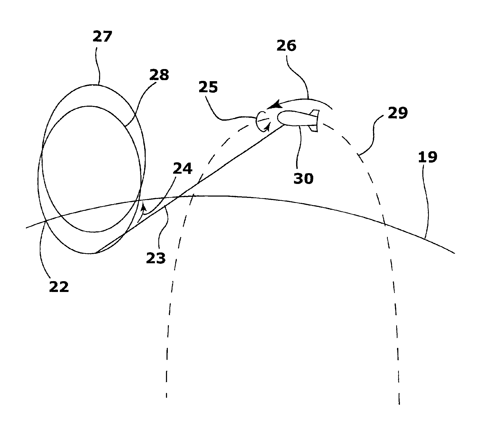
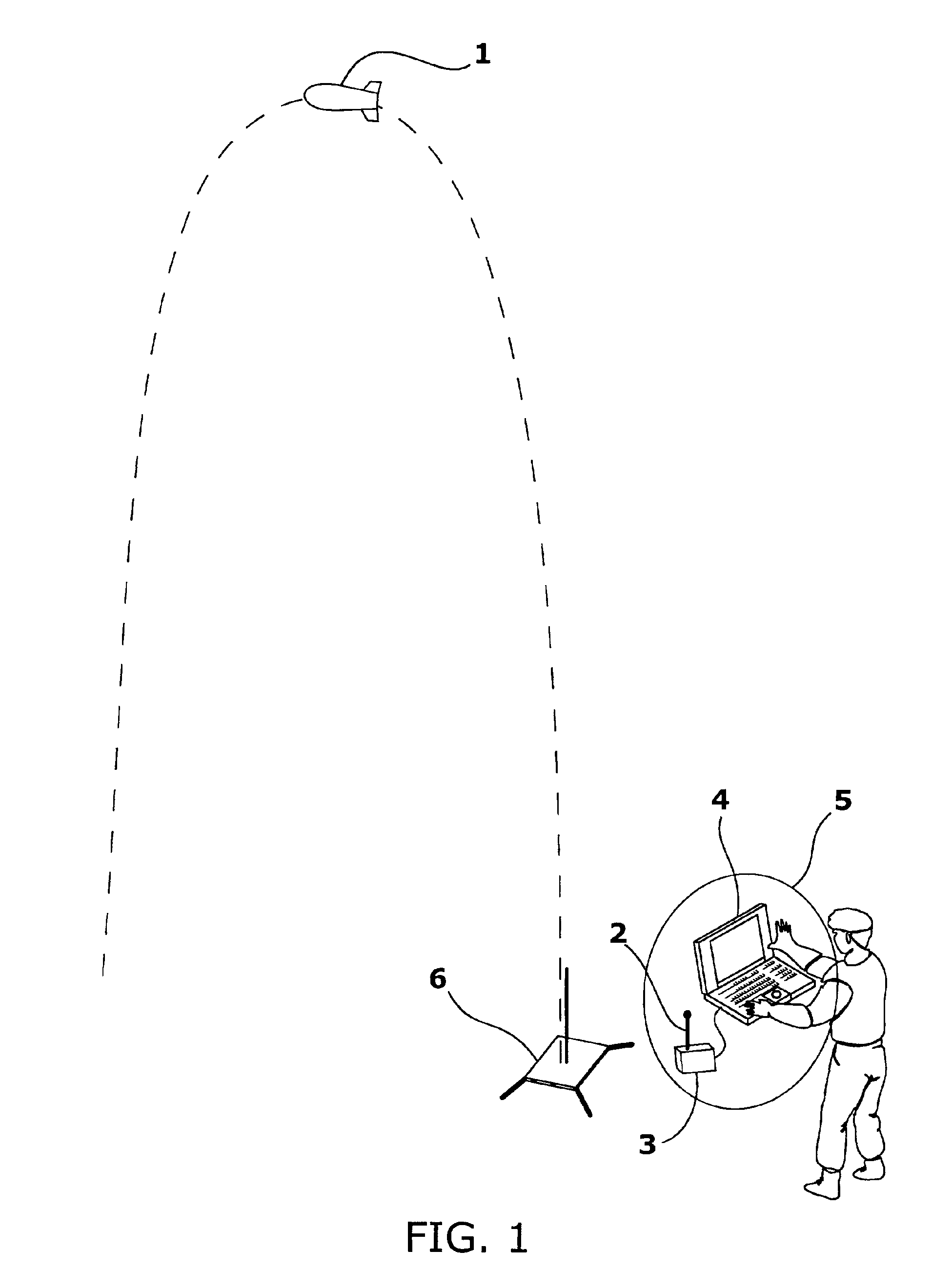
[0024]FIG. 1 shows a device 1 according to the invention launched in a ballistic trajectory, from a small, portable launch pad 6. The images from the device 1 are transmitted to the operator with a portable ground station 5 where they are received by the receiver 3 using the antenna 2, and transferred to the portable computer 4. The computer arranges the images in a complete panorama, covering the entire area as seen by the flight vehicle 1 at the top of its trajectory.

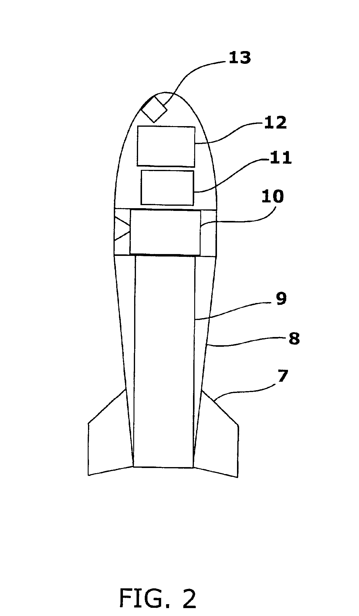
[0025]FIG. 2 shows a cut away detail of one flight vehicle according to the invention. It is launched into the air using a small solid fueled rocket motor 9. Those of ordinary skill in the art will appreciate that the ideal height of launch will depend on the area to be viewed and the quality of the imager, and may range from as low as ten feet to as high as 30,000 feet, or even up to 100,000 feet or more for some vehicles. The best propulsion device will depend upon the desired height, and possibly on other factors s...


PUM


Abstract

An imaging device that gives a ground based user immediate access to a detailed aerial photograph of the entire area for a given radius about his present position. The device can be launched into the air, and rotates in a predictable pattern to scan an imager over every point of the ground, from a vantage point high in the air. These pictures can be stored or transmitted to the ground and assembled on a computer to form a spherical picture of everything surrounding the imaging device in the air.

Description

[0001]This application claims benefit of U.S. Provisional Application No. 60 / 275,378, filed Mar. 13, 2001, which is incorporated by reference herein.FIELD OF THE INVENTION[0002]The present invention relates generally to a device to take a spherical or hemispherical panoramic image from a specific point in the air, and more particularly, to a simple device with no moving parts that rotates about two axes to scan the imaging device over the ground in two axes, such that the images can be put together to create a panoramic image.BACKGROUND OF THE INVENTION[0003]A person on the ground, such as a soldier, may need to know what is in the immediately surrounding area. Reconnaissance of an area can often be efficiently done from the air. (For example, it has been reported that tanks operating in urban environments require helicopter support before turning a street corner, to detect anti-tank weapons). However, manned aircraft are expensive, not always readily available, may not have access ...

Claims


Application Information

Patent Timeline
Patent Type & Authority Patents(United States)
IPC IPC(8): G01C11/02G01C11/00F42B12/36F42B12/02F41G3/00F41G3/02
CPCF41G3/02F42B12/365G01C11/02
Inventor HEAFITZ, ANDREW
Owner TACSHOT
Why Eureka
Try Eureka