Culled satellite ephemeris information for quick, accurate assisted locating satellite location determination for cell site antennas

a cell site antenna and satellite ephemeris technology, applied in the field of satellite ephemeris information for quick, accurate assisted locating satellite location determination of cell site antennas, can solve problems such as satellite location changes

Inactive Publication Date: 2006-09-26
TELECOMM SYST INC
View PDF4 Cites 22 Cited by
  • Summary
  • Abstract
  • Description
  • Claims
  • Application Information

AI Technical Summary

Problems solved by technology

Unfortunately, as the phone moves about the country, locations with respect to satellites change.

Method used


Image

  • Culled satellite ephemeris information for quick, accurate assisted locating satellite location determination for cell site antennas
  • Culled satellite ephemeris information for quick, accurate assisted locating satellite location determination for cell site antennas
  • Culled satellite ephemeris information for quick, accurate assisted locating satellite location determination for cell site antennas

Examples


Embodiment Construction

[0025]In a conventional GPS system, ephemeris data is provided to each GPS receiver to keep track of where each of the satellites in the GPS satellite network should be located in space. As part of the location determination process, each GPS receiver determines which of approximately 24 or more GPS satellites are to be used to determine GPS location. This determination requires a significant amount of real-time processing at the time of the location request, and a significant amount of time.

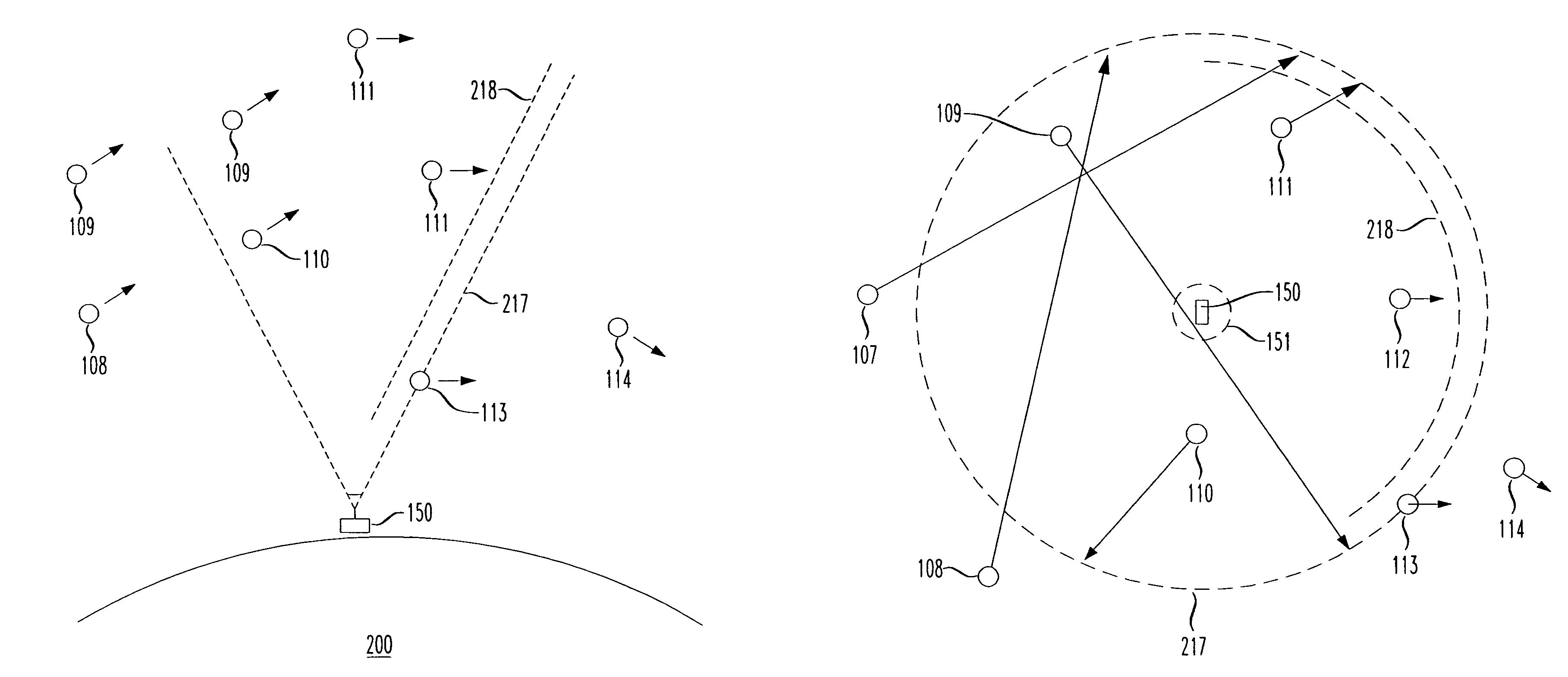
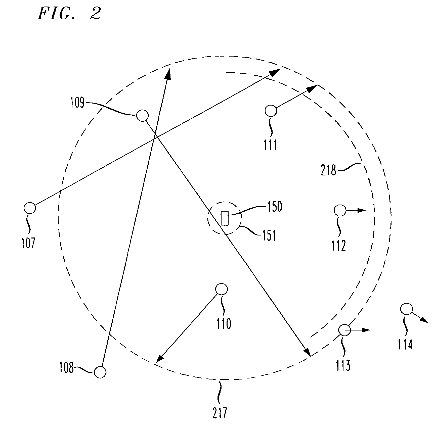
[0026]FIG. 1 shows a base station 150 of a wireless network (e.g., a cellular telephone network) determining which GPS satellites 101–124 are in a preferred group, e.g., being within a cone of space 217 with the longest dwell time within that space, in accordance with the principles of the present invention.

[0027]In particular, as shown in FIG. 1, of the twenty four or so GPS satellites 101–124 in the GPS system, only a sub-set 107–114 are visible to the base station 150 at any one time. Thus, b...


PUM


Abstract

Locating satellites (e.g., GPS) are culled into a preferred group having a longest dwell time based on a time passing through an ellipsoid arc path through a cone of space, and communicated to mobile devices within a particular region (e.g., serviced by a particular base station). The culled locating satellites may select those visible, or more preferably those locating satellites currently within a cone of space above the relevant base station are selected for communication by a mobile device within the service area of the base station. The inverted cone of space may be defined for each antenna structure for any given base station, and each has 360 degrees of coverage, or less than 360 degrees of coverage, with relevant locating satellites. Thus, cell sites may be specifically used as reference points for culling the ephemeris information used to expedite Assisted GPS location determinations.

Description

[0001]This application claims priority from U.S. application Ser. No. 11 / 080,518, filed Mar. 16, 2005; which in turn claims Priority from U.S. Provisional Application 60 / 618,606, filed Oct. 15, 2004, the entirety of both of which are expressly incorporated herein by reference.BACKGROUND OF THE INVENTION[0002]1. Field of the Invention[0003]This invention relates generally to wireless and long distance carriers, Internet service providers (ISPs), and information content delivery services / providers and long distance carriers. More particularly, it relates to location services for the wireless industry.[0004]2. Background of Related Art[0005]It is desired to accurately locate cell phones within a cellular network. While there are several techniques for determining location in a mobile device, a future generation of mobile phones may include a global positioning satellite (GPS) receiver chipset, thus having the ability to locate itself via GPS.[0006]FIG. 10 depicts the conventional Globa...

Claims


Application Information

Patent Timeline
Patent Type & Authority Patents(United States)
IPC IPC(8): H04B7/185G01S19/05
CPCG01S19/05
Inventor PITT, LANCE DOUGLASLAMPRECHT, LESLIE JOHANNMARTIN, JEFFREY THOMAS
Owner TELECOMM SYST INC
Why Eureka
Try Eureka