
Systems and methods for automatic detection of QFE operations

a technology of automatic detection and qfe, applied in the direction of vehicle position/course/altitude control, process and machine control, instruments, etc., can solve the problems of aircraft being vulnerable to controlled flight into terrain, other aircraft systems producing false alerts

Inactive Publication Date: 2008-06-17
HONEYWELL INT INC
View PDF4 Cites 18 Cited by
  • Summary
  • Abstract
  • Description
  • Claims
  • Application Information

AI Technical Summary

Benefits of technology

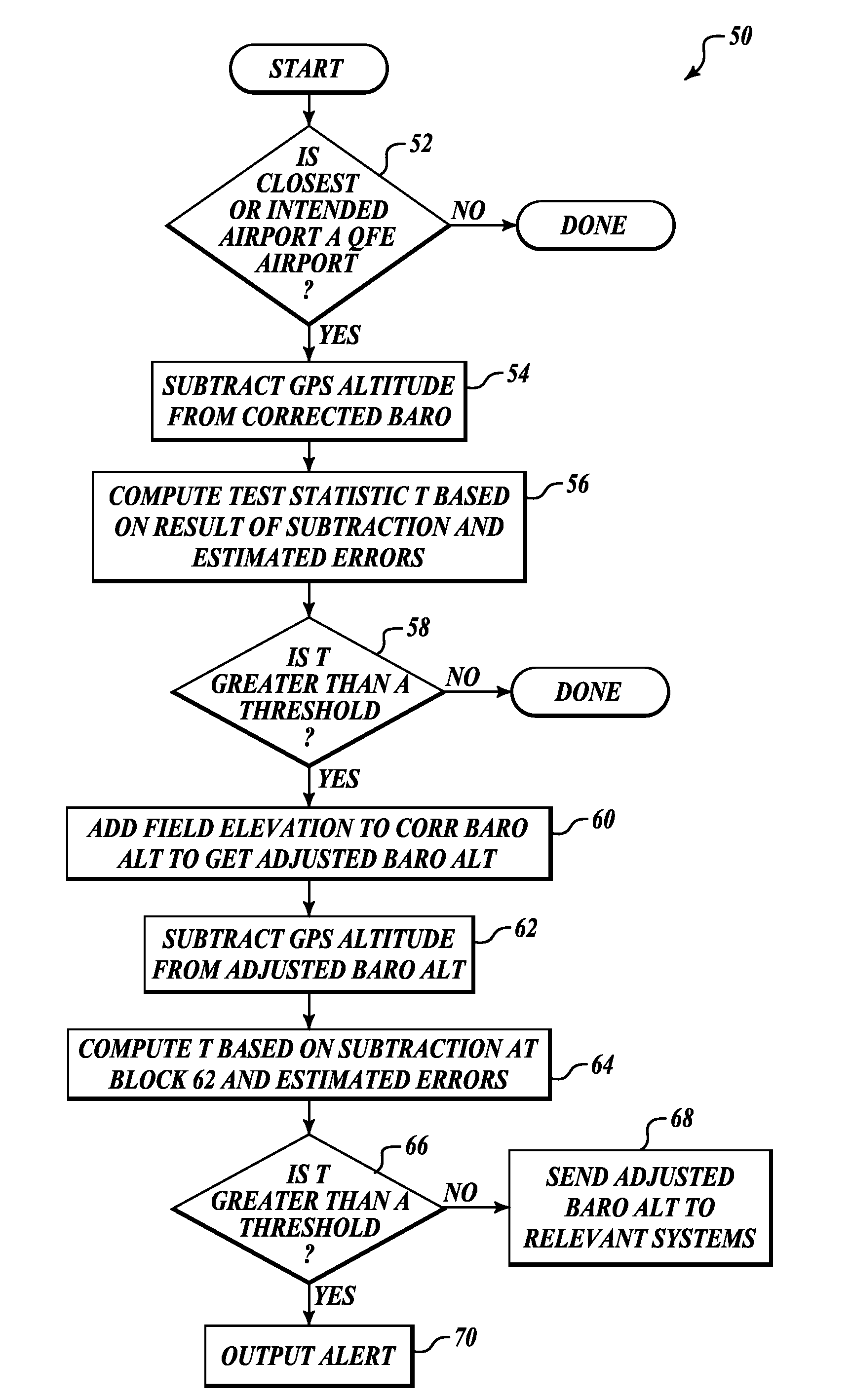
[0003]The present invention provides systems and methods for determining if an aircraft is approaching a QFE airport and for alerting if any errors that might affect the production of an accurate altitude value. In an example method a global positioning system (GPS) altitude value is compared to a corrected barometric altitude, if an airport that the aircraft is proximate to (approaching) is

Problems solved by technology

However, if the aircrew fails to make sure the other aircraft systems understand that the barometric altimeter is based on QFE operation, then the other aircraft systems will produce false alerts.
Because of the number of tasks performed on an approach to landing, the flight crew may be overloaded and not want to bother with figuring out the cause of the alert and thus just deactivate the TAWS.
Deactivation of the TAWS leaves the aircraft vulnerable to controlled flight into terrain (CFIT).

Method used


Image

  • Systems and methods for automatic detection of QFE operations
  • Systems and methods for automatic detection of QFE operations
  • Systems and methods for automatic detection of QFE operations

Examples


Embodiment Construction

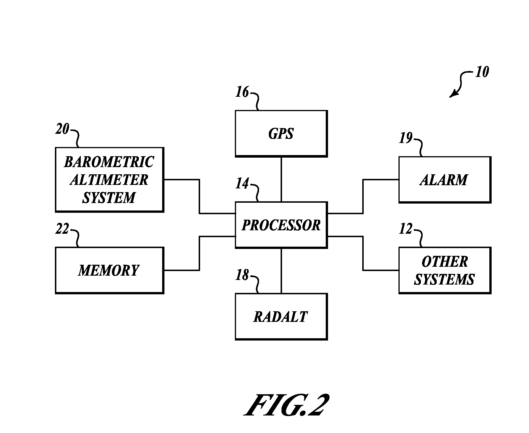
[0010]FIG. 2 is a block diagram of an example system 10 for monitoring if an aircraft is approaching a QFE airport, applying appropriate corrections and alerting the flight crew if necessary. The system 10 includes a processor 14 that is in data and signal communication with other aircraft systems 12, a global positioning system (GPS) 16 or similar position determining system, a radio / radar altimeter (RADALT) 18, an alarm device 19, a barometric altimetry system 20, and memory 22.

[0011]The processor 14 includes a software application program that based on aircraft location information received from the GPS 16 or some other source and stored airport information in the memory 22 or a QFE signal from a transmitting airport ATIS signal, determines if the corrected barometric pressure indicates that the aircraft is performing a QFE operation. If the processor 14 determines that the aircraft is performing a QFE operation, then the barometric altimeter reading is adjusted accordingly (manu...


PUM


Abstract

Systems and methods for determining if an aircraft is approaching a atmospheric pressure at field elevation (QFE) airport and for alerting if any errors that might affect the production of an accurate altitude value. In an example method a global positioning system (GPS) altitude value is compared to a corrected barometric altitude, if an airport that the aircraft is proximate to (approaching) is a QFE airport. The field elevation of the proximate airport is added to the corrected barometric altitude to generate an adjusted barometric altitude, if the comparison between the GPS altitude and the corrected barometric altitude is greater than a predefined threshold. The adjusted barometric altitude is sent to relevant aircraft systems, such as an Enhanced Ground Proximity Warning System.

Description

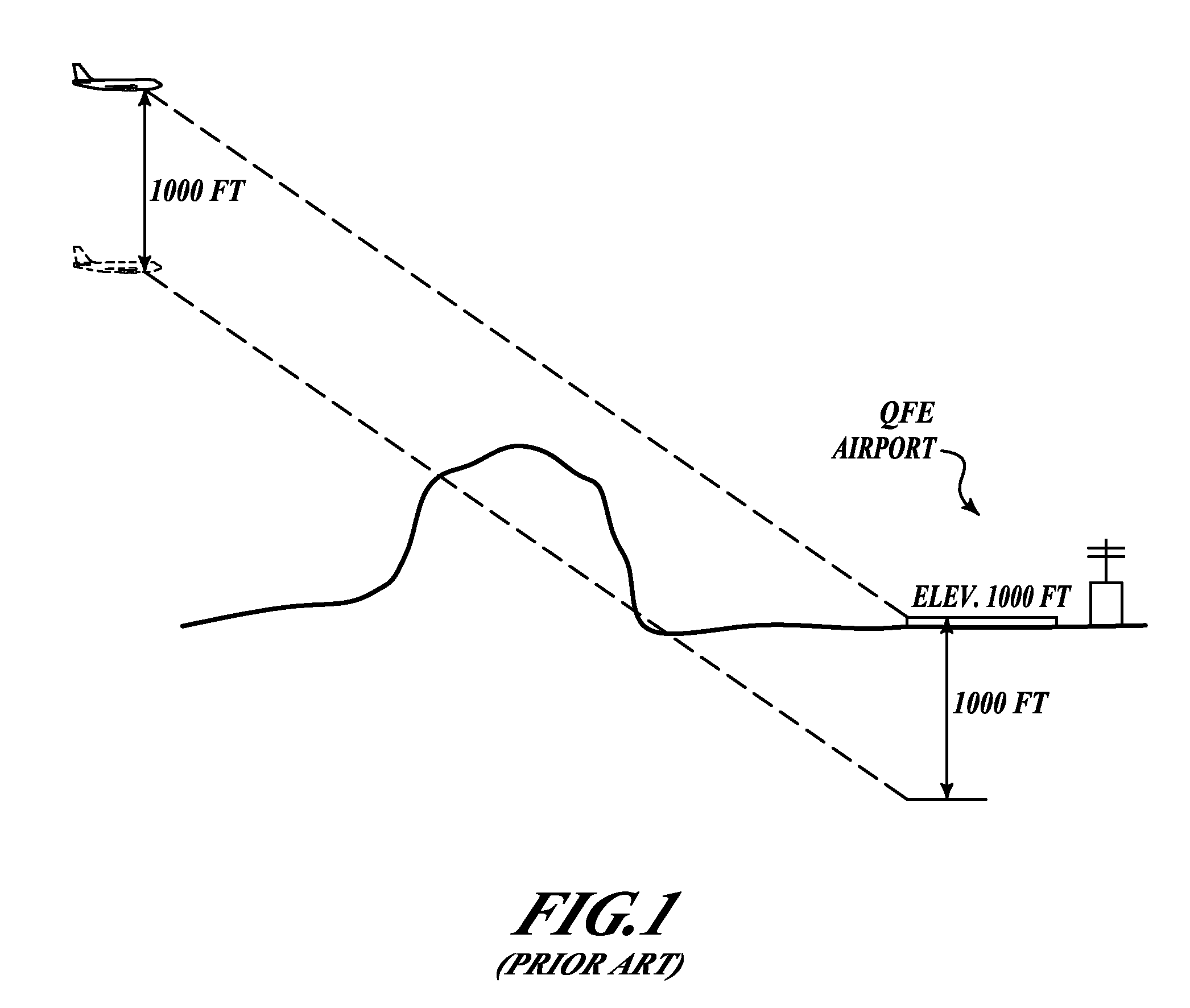
BACKGROUND OF THE INVENTION[0001]Some airports around the world still operate under the practice of atmospheric pressure at field elevation (QFE). At QFE airports, Automatic Terminal Information Service (ATIS) or a similar outputted system outputs a barometric pressure setting value. This value is one that when an aircraft is positioned on the ground at the airport the barometric altimeter reading in the aircraft will read zero regardless of the altitude of the airport. Therefore, as shown in FIG. 1, if an aircraft is flying to a QFE airport that is at the elevation of 1000 feet, the barometric altimeter indicates that the aircraft is 1000 feet lower than it actually is. This does not become a problem if the aircrew informs all systems within the aircraft that use barometric pressure that it is based on a QFE setting. However, if the aircrew fails to make sure the other aircraft systems understand that the barometric altimeter is based on QFE operation, then the other aircraft syste...

Claims


Application Information

Patent Timeline
IPC IPC(8): G01C5/00
CPCG01C5/005
Inventor CONNER, KEVIN JJOHNSON, STEVE C.ISHIHARA, YASUO
Owner HONEYWELL INT INC
Learn More